|
|
| Montgomery Field |
 |
| IATA: MYF – ICAO: KMYF – FAA LID: MYF |
| Summary |
| Airport type |
Public |
| Operator |
City of San Diego |
| Location |
San Diego, California |
| Elevation AMSL |
427 ft / 130.1 m |
| Coordinates |
32°48′57″N 117°08′22″W / 32.81583°N 117.13944°W / 32.81583; -117.13944Coordinates: 32°48′57″N 117°08′22″W / 32.81583°N 117.13944°W / 32.81583; -117.13944 |
| Runways |
| Direction |
Length |
Surface |
| ft |
m |
| 5/23 |
3,400 |
1,036 |
Asphalt |
| 10L/28R |
4,577 |
1,395 |
Asphalt |
| 10R/28L |
3,401 |
1,037 |
Asphalt |
| Helipads |
| Number |
Length |
Surface |
| ft |
m |
| H1 |
100 |
30 |
Asphalt |
| H2 |
48 |
15 |
Asphalt |
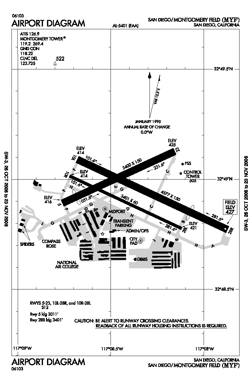
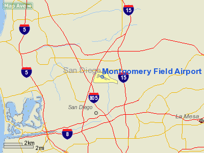
Montgomery Field (IATA: MYF, ICAO: KMYF, FAA LID: MYF) is a public airport located in San Diego, California, United States, six miles (10 km) north of the central business district (CBD) of San Diego. The airport covers 456 acres (185 ha) and has three runways and two helipads. The runway configuration is 28 Right/10 Left-28 Left/10 Right parallels with Runway 5/23 crossing at midfield.
The Federal Aviation Administration has maintained an Air Traffic Control Tower at the airport since 1965. It is located on the north side of the airport, just east of Taxiway C and Runway 23/5.
It is named for John J. Montgomery, an aviation pioneer who in 1883 made the first manned, controlled, heavier-than-air flights in the Otay Mesa area of San Diego. Montgomery Field is one of the nation's busiest airports for small aircraft and has a number of flying clubs, flight schools, plus business turboprops and jets based there. San Diego FD bases aircraft there. King Schools is based nearby and their aircraft are based at the airport. Since Summer 2009, King Schools (in conjunction with Cessna) has been flight testing the prototype Cessna 162 Skycatcher Light-Sport Aircraft at or around the airport.
Accidents and incidents
- On September 25, 1978, a Cessna 172 registered as N7711G took off from Montgomery Field and proceeded to Lindbergh Field to do a practice instrument landing (ILS) approach. During their eastbound departure from Lindbergh, PSA Flight 182 (N533PS) was on an easterly downwind descent for landing. The PSA Boeing 727 overtook and collided with the Cessna from behind, causing N7711G to disintegrate and flight 182 to crash. This incident led to the establishment of Terminal Control Areas/TCAs. This was the first positive control airspace surrounding airports.
- On February 19, 2010, a Cirrus SR-22 Turbo Gen-3 registered as N443CP, was stolen from Montgomery Field and proceeded to LAX
The above content comes from Wikipedia and is published under free licenses – click here to read more.
Location
& QuickFacts
|
FAA
Information Effective: |
2006-09-28 |
|
Airport
Identifier: |
MYF |
|
Longitude/Latitude: |
117-08-22.5000W/32-48-56.6000N
-117.139583/32.815722 (Estimated) |
|
Elevation: |
427 ft / 130.15 m (Surveyed) |
|
Land: |
456 acres |
|
From
nearest city: |
6 nautical miles N of San Diego, CA |
|
Location: |
San Diego County, CA |
|
Magnetic Variation: |
13E (1985) |
Owner
& Manager
|
Ownership: |
Publicly owned |
|
Owner: |
City Of San Diego |
|
Address: |
3750 John J Montgomery Dr
San Diego, CA 92123 |
|
Phone
number: |
858-573-1440 |
|
Manager: |
Michael C. Tussey |
|
Address: |
3750 John J Montgomery Dr
San Diego, CA 92123 |
|
Phone number: |
858-573-1440 |
Airport
Operations and Facilities
|
Airport
Use: |
Open to public |
|
Wind
indicator: |
Yes |
|
Segmented
Circle: |
Yes |
|
Control
Tower: |
Yes |
|
Attendance
Schedule: |
ALL/M-F/0600-1800 |
|
Lighting
Schedule: |
DUSK-DAWN
WHEN ATCT CLSD ACTVT MIRL RY 10L/28R MALSR RY 28R; VASI
RYS 10L & 28R - FREQ 119.2. |
|
Beacon
Color: |
Clear-Green (lighted land airport) |
|
Landing
fee charge: |
No |
|
Sectional
chart: |
Los Angeles |
|
Region: |
AWP - Western-Pacific |
|
Boundary
ARTCC: |
ZLA - Los Angeles |
|
Tie-in
FSS: |
SAN - San Diego |
|
FSS
on Airport: |
Yes |
|
FSS
Phone: |
858-277-7043 |
|
FSS
Toll Free: |
1-800-WX-BRIEF |
|
NOTAMs
Facility: |
MYF (NOTAM-d service avaliable) |
|
Federal Agreements: |
NGY |
Airport
Communications
|
CTAF: |
119.200 |
|
Unicom: |
122.950 |
Airport
Services
|
Fuel
available: |
100LLA |
|
Airframe
Repair: |
MAJOR |
|
Power
Plant Repair: |
MAJOR |
|
Bottled
Oxygen: |
LOW |
|
Bulk
Oxygen: |
HIGH |
|
Runway Information
Runway 05/23
|
Dimension: |
3400 x 150 ft / 1036.3 x 45.7 m |
|
Surface: |
ASPH, Good Condition |
|
Weight
Limit: |
Single wheel: 12000 lbs. |
|
|
Runway 05 |
Runway 23 |
|
Longitude: |
117-08-45.6181W |
117-08-09.5208W |
|
Latitude: |
32-48-53.4698N |
32-49-07.6906N |
|
Elevation: |
416.00 ft |
425.00 ft |
|
Alignment: |
65 |
127 |
|
Traffic
Pattern: |
Left |
Left |
|
Markings: |
Basic, Good Condition |
Basic, Good Condition |
|
Displaced
threshold: |
389.00 ft |
0.00
ft |
|
Runway
End Identifier: |
No |
No |
|
Centerline
Lights: |
No |
No |
|
Touchdown
Lights: |
No |
No |
|
Obstruction: |
118 ft pline, 3200.0 ft from runway, 150 ft
left of centerline, 25:1 slope to clear
30:1 APCH SLOPE TO DSPLCD THR. |
40 ft tree, 1400.0 ft from runway, 60 ft left
of centerline, 30:1 slope to clear |
|
Runway 10L/28R
|
Dimension: |
4577 x 150 ft / 1395.1 x 45.7 m |
|
Surface: |
ASPH, Good Condition |
|
Surface
Treatment: |
Rubberized Friction Seal Coat |
|
Weight
Limit: |
Single wheel: 12000 lbs. |
|
Edge
Lights: |
Medium |
|
|
Runway 10L |
Runway 28R |
|
Longitude: |
117-08-40.8604W |
117-07-52.2549W |
|
Latitude: |
32-49-05.3884N |
32-48-46.2624N |
|
Elevation: |
414.00 ft |
427.00 ft |
|
Alignment: |
115 |
127 |
|
ILS
Type: |
|
ILS/DME |
|
Traffic
Pattern: |
Left |
Right |
|
Markings: |
Non-precision instrument, Good Condition |
Precision instrument, Good Condition |
|
Crossing
Height: |
40.00 ft |
29.00 ft |
|
Displaced
threshold: |
0.00
ft |
1176.00 ft |
|
VASI: |
4-box on left side |
4-box on left side |
|
Visual
Glide Angle: |
3.00� |
3.00� |
|
Approach
lights: |
|
MALSR |
|
Runway
End Identifier: |
No |
No |
|
Centerline
Lights: |
No |
No |
|
Touchdown
Lights: |
No |
No |
|
Obstruction: |
75 ft tree, 1000.0 ft from runway, 10:1 slope
to clear |
, 50:1 slope to clear
50:1 APCH SLOPE TO DSPLCD THLD. |
|
Runway 10R/28L
|
Dimension: |
3401 x 60 ft / 1036.6 x 18.3 m |
|
Surface: |
ASPH, Good Condition |
|
Surface
Treatment: |
Rubberized Friction Seal Coat |
|
Weight
Limit: |
Single wheel: 12000 lbs. |
|
|
Runway 10R |
Runway 28L |
|
Longitude: |
117-08-43.3216W |
117-08-07.2071W |
|
Latitude: |
32-49-00.9012N |
32-48-46.6902N |
|
Elevation: |
414.00 ft |
421.00 ft |
|
Alignment: |
115 |
127 |
|
Traffic
Pattern: |
Right |
Left |
|
Markings: |
Basic, Good Condition |
Basic, Good Condition |
|
Runway
End Identifier: |
No |
Yes |
|
Centerline
Lights: |
No |
No |
|
Touchdown
Lights: |
No |
No |
|
Obstruction: |
45 ft tree, 1000.0 ft from runway, 17:1 slope
to clear |
70 ft tree, 1750.0 ft from runway, 280 ft left
of centerline, 22:1 slope to clear |
|
Helipad H1
|
Dimension: |
100 x 100 ft / 30.5 x 30.5 m |
|
Surface: |
ASPH, Good Condition |
|
|
Runway H1 |
Runway |
|
Traffic
Pattern: |
Left |
Left |
|
Helipad H2
|
Dimension: |
48 x 48 ft / 14.6 x 14.6 m |
|
Surface: |
ASPH, Good Condition |
|
|
Runway H2 |
Runway |
|
Traffic
Pattern: |
Left |
Left |
|
Radio Navigation
Aids
|
ID |
Type |
Name |
Ch |
Freq |
Var |
Dist |
|
SAN |
FAN MARKER |
Encat |
|
|
15E |
6.8 nm |
|
UN |
NDB |
Tijuana |
|
381.00 |
14E |
17.8 nm |
|
NKX |
TACAN |
Miramar |
033X |
|
15E |
3.3 nm |
|
NZY |
TACAN |
North Island |
117X |
|
14E |
7.8 nm |
|
NRS |
TACAN |
Imperial Beach |
029X |
|
14E |
15.2 nm |
|
NFG |
TACAN |
Camp Pendleton |
055X |
|
13E |
30.3 nm |
|
NKX |
UHF/NDB |
Miramar |
|
352.00 |
15E |
3.5 nm |
|
TIJ |
VOR/DME |
Tijuana |
112X |
116.50 |
14E |
19.0 nm |
|
MZB |
VORTAC |
Mission Bay |
125X |
117.80 |
15E |
4.8 nm |
|
PGY |
VORTAC |
Poggi |
035X |
109.80 |
14E |
14.8 nm |
|
OCN |
VORTAC |
Oceanside |
100X |
115.30 |
15E |
29.1 nm |
|
JLI |
VORTAC |
Julian |
087X |
114.00 |
15E |
34.1 nm |
|
SAN |
VOT |
Mount Soledad |
|
109.00 |
|
5.9 nm |
|
SEE |
VOT |
Gillespie Field |
|
110.00 |
|
8.4 nm |
Remarks
- BE
ALERT HVY ACFT ACTIVITY IN THE VICINITY OF LAKE MURRAY & MT SOLEDAD.
PILOTS ARE URGED TO BE VIGILANT FOR OTHER ACFT IN THESE AREAS &
TO CTC THE TWR EARLY ENOUGH FOR TIMELY TFC ADVISORIES IF PROCEDING EAST
BOUND ADVISE TWR OF DESTINATION ARPT.
- ARPT
USE RESTRICTED BY AMGR TO ACFT HAVING A MAXIMUM CERTIFICATED GROSS TKOF
WGT OF 20,000 LBS OR LESS.
- TOUCH
AND GO OPNS ARE PROHIBITED 2100-0630. INTERSECTION TKOFS AND STOP AND
GO'S ARE PROHIBITED AT ALL TIMES. PRACTICE LOW APPROACHES ARE PROHIBITED
2330-0630. SIMULATED ENGINE FAILURES ARE PROHIBITED OVER RESIDENTIAL
AREAS.
- NO
JET TOUCH AND GO OPNS AND NO TOUCH AND GO OPNS OR LOW APCH TRAINING
2100-0630 .
- FOR
NOISE ABATEMENT REGULATIONS CONTACT THE NOISE ABATEMENT OFFICE AT 858-573-1436.
- ACFT
WITH HIGH NOISE LEVELS ARE REQUESTED TO USE RY 10L/28R
- NO
SIMULATED ENGINE FAILURES OVER RESIDENTIAL AREAS.
- (CONTACT
TITLE) MGR - EGESELL@SANDIEGO.GOV ARP OPNS - BILL DALBY - WDALBY@SANDIEGO.GOV
- BE
ALERT TO MILITARY JET ACFT INVOF OF ARPT & 4.7 NM NW OF ARPT BEARING
312 INVOF MISSION BAY VORTAC.
- EXTRM
NOISE SENSITIVE AREAS W & S OF ARPT. NOISE MONITORING IN EFFECT.
MAX NOISE LMT 2330-0630 70 DB OVER RESIDENTIAL AREAS.
MAX NOISE LMT 0630-2330
88 DB.
- NO
PRACTICE LOW APCHS 2330-0630.
- BE
ALERT BIRDS ON AND INVOF ARPT; COYOTE ACTIVITY ON RYS & TWYS.
Based Aircraft
|
Aircraft
based on field: |
555 |
|
Single
Engine Airplanes: |
445 |
|
Multi
Engine Airplanes: |
59 |
|
Jet Engine
Airplanes: |
13 |
|
Helicopters: |
37 |
|
Gliders: |
1 |
Operational Statistics
|
Aircraft
Operations: |
672/Day |
|
Air Taxi: |
1.5% |
|
General
Aviation Local: |
46.7% |
|
General
Aviation Itinerant: |
51.7% |
|
Military: |
0.1% |
Montgomery Field Airport
Address:
San Diego County, CA
Tel:
858-573-1440
Images
and information placed above are from
http://www.airport-data.com/airport/MYF/
We
thank them for the data!
| General
Info |
| Country |
United
States |
| State |
CALIFORNIA
|
| FAA ID |
MYF
|
| Latitude |
32-48-56.639N
|
| Longitude |
117-08-22.439W
|
| Elevation |
427 feet
|
| Near City |
SAN DIEGO
|
We don't guarantee the information is fresh and accurate. The data may
be wrong or outdated.
For more up-to-date information please refer to other sources.
|
|