|
 |
|
||||
|
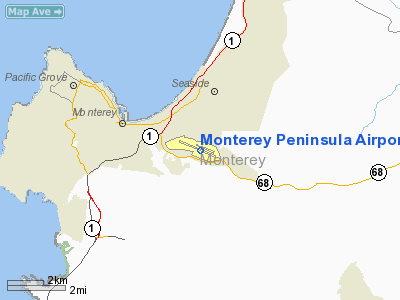
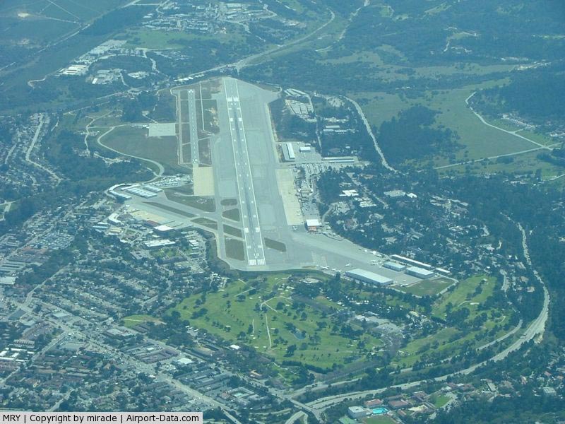
Monterey Peninsula Airport (IATA: MRY, ICAO: KMRY, FAA LID: MRY) is a regional airport located three miles (5 km) southeast of the central business district (CBD) of Monterey, a city in Monterey County, California, USA. It was created in 1936. The airport is owned by the several municipalities that make up the Monterey Peninsula Airport District. It is a public entity, and its five member Board of Directors is publicly elected. Monterey-Salinas Transit is the public ground transit organization serving the airport. FacilitiesMonterey Peninsula Airport covers 597 acres (242 ha) and has two runways:
MRY has built a new baggage claim and a centralized screening area. Airlines and destinations
Fixed Base OperatorsThere are five fixed base operators located at the Monterey Peninsula Airport:
Accidents and incidentsOn June 14, 1964 at about 7:35pm, a Piper PA-28 (tail number N5384W) collided with trees in Monterey, California killing the 34 year old student pilot. The investigation into the fatal accident revealed that the pilot misjudged his altitude, flying too low and under the influence of alcohol. The crash also caused the Piper to catch fire. On August 17, 1968 at about 12:36pm, a Cessna 210 (tail number N9676T) stalled while landing at the Monterey Peninsula Airport. During the landing, the 48 year old pilot suffered a heart attack which caused his Cessna to stall. The Cessna was destroyed upon impact. The pilot had about 5,743 flight hours of experience. On July 26, 1979 at about 9:43pm, a Cessna 320A (tail number N3005R) crashed into the ground during its final approach to the Monterey Peninsula Airport. The 62 year old pilot used improper Instrument Flight Rules operations, which caused his collision. The pilot had about 3,621 flight hours of experience. On August 23, 1984 at about 8:51pm, a Cessna 320C (tail number N7AE) departed from the Monterey Peninsula Airport under Special Visual Flight Rules with one 58 year old pilot and four passengers. At about 8:55pm, Air Traffic Control advised N7AE to turn left to avoid rising terrain. The Cessna was unable to avoid the terrain, crashed, and caught fire. The pilot and all passengers were killed. The investigation reveled that the pilot made poor decisions and did not follow instructions from Air Traffic Control. The pilot had about 2,041 hours of flight experience. On July 27, 1985 at about 12:52, a Piper PA-28-235 (tail number N15548) took off from the Monterey Peninsula Airport to practice holding patterns over Monterey Bay. About twelve minutes into the flight, the 60 year old pilot radioed Air Traffic Control, "Mayday, rough engine." The Piper disappeared from the Air Traffic Control's radar at about 1300 feet. Later the United States Coast Guard discovered pieces of the Piper in the ocean. The investigation revealed that the pilot used improper procedures. The pilot had about 1,923 hours of flight experience. On July 24, 1987 at about 10:11am, a Piper PA-32R-301T (tail number N82793) was cleared for an Instrument Landing System approach when the 39 year old pilot decided to conduct a go around procedure. About thirty seconds after initiating the procedure, the pilot radioed Air Traffic Control, "Seven niner three, in trouble." Sixteen seconds later another transmission is broadcasted, "I have, I have an emergency back here." The Piper was seen making a 400 foot decent below assigned altitude and disappeared into Monterey Bay. A boater who witnessed the collision reported seeing the Piper "dive out" of a cloud and colliding with the water. The investigation revealed that the pilot experienced spatial disorientation and lacked instrument flying time. The pilot had about 528 hours of flight experience. On September 8, 1987 at about 5:50pm, a Beechcraft 95 (tail number N845B), being flowing by a 31 year old student pilot, was conducting multi engine training at the Monterey Peninsula Airport. During the training, the pilot started practicing Instrument Landing System approaches. During an approach for a landing, the Beechcraft crashed into the ground. The investigation revealed that there was inadequate supervision during the training exercise. Both the pilot and student pilot were killed. On June 24, 1992 at about 10:30am, a Cessna 421B (tail number N628RJ), the 40 year old pilot and two passengers took off from the Monterey Peninsula Airport. About three minutes after takeoff the Cessna collided with a hill about three miles east of the airport. The investigation revealed that ground fog and overconfidence in the pilot caused the accident. All three were killed in the collision. The pilot had about 75 hours of flight experience. On August 7, 1997 at about 8:00pm, a Grumman American AA-5 (tail number N6086L) took off from the Monterey Peninsula Airport. The Grumman was later found 18 miles south of the airport. It has crashed into the mountains which caused the Grumman to catch fire. The 31 year old pilot had about 4,000 hours of flight experience. On October 12, 1997 at about 5:28pm, a Rutan Long-EZ (tail number N555JD) being flown by John Denver crashed into Monterey Bay near Pacific Grove, California. After taking off from the Monterey Peninsula Airport, the Long-EZ started its climb then descended into bay. The investigation revealed that the collision was caused by the fuel valve selector being in an improper position. Inadequate flight planning also contributed to the collision. John Denver had about 2,750 hours of flight experience. The above content comes from Wikipedia and is published under free licenses – click here to read more.
Runway InformationRunway 10L/28R
Runway 10R/28L
Radio Navigation Aids
Remarks
Based Aircraft
Major Carriers Serving This Airport
Most Popular Destinations
Most Popular Aircraft
Operational Statistics
Monterey Peninsula Airport Address: Monterey County, CA Tel: 831-648-700 Images
and information placed above are from We thank them for the data!
We don't guarantee the information is fresh and accurate. The data may
be wrong or outdated. |
||||||||||||||||||||||||||||||||||||||||||||||||||||||||||||||||||||||||||||||||||||||||||||||||||||||||||||||||||||||||||||||||||||||||||||||||||||||||||||||||||||||||||||||||||||||||||||||||||||||||||||||||||||||||||||||||||||||||||||||||||||||||||||||||||||||||||||||||||||||||||||||||||||||||||||||||||||||||||||||||||||||||||||||||||||||||||||||||||||||||||||||||||||||||||||||||||||

 |
|
Copyright 2004-2024 © by Airports-Worldwide.com, Vyshenskoho st. 36, Lviv 79010, Ukraine Legal Disclaimer |