Monterey Bay Academy Airport in California California airports - Monterey Bay Academy Airport
Monterey Bay Academy Airport in California - United States
California Airports
USA Airports
World Airports
Airport photos - free!
Aircraft photos - free!
Spacecraft pics - free!
Aviation Articles

Monterey Bay Academy Airport


Monterey Bay Academy Airport
IATA: none – ICAO: none – FAA LID: CA66
Summary
Airport type Private
Operator Seventh-day Adventist Church
Location Monterey Bay Academy
Elevation AMSL 70 ft / 21 m
Coordinates 36°54′22″N 121°50′35″W / 36.90611°N 121.84306°W / 36.90611; -121.84306Coordinates: 36°54′22″N 121°50′35″W / 36.90611°N 121.84306°W / 36.90611; -121.84306
Runways
Direction Length Surface
ft m
10/28 2,200 671 Soil

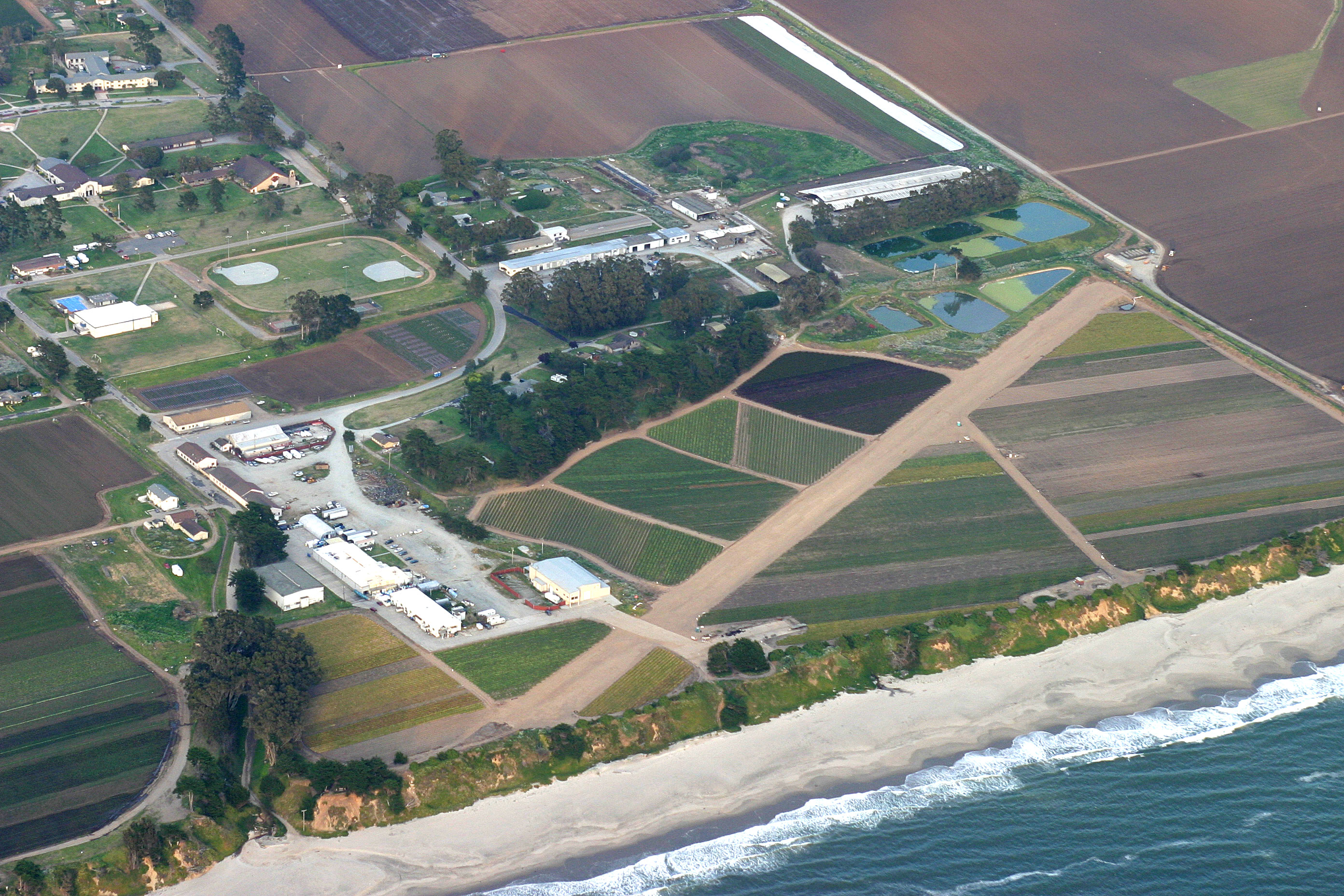
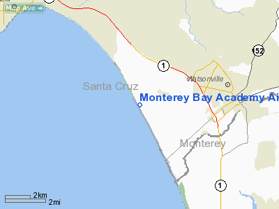
Monterey Bay Academy Airport (FAA LID: CA66) is located near the city of Watsonville in Santa Cruz County, California, USA. This private use airport is owned by the Seventh-day Adventist Church and located on the campus of the Monterey Bay Academy, site of the former Camp McQuaide.

History

In 1926, the 63rd coastal artillery regiment moved from Santa Cruz, California, to an area just east of the town of Capitola. Its camp was named for Major Joseph P. McQuaide, who was born in 1867 at graduated from Santa Clara University. He served as Chaplain of the California National Guard in the Spanish American War and World War I, and died March 29, 1924. By 1938, noise from target practice annoyed Capitola residents, so a more remote place was found. 379 acres (1.53 km) were purchased farther south, on coastal farmland near the town of Watsonville. The Works Progress Administration built San Andreas road to the new site.

A small aircraft landing strip was built so airplanes could drop targets into the ocean. It became the training center of what was then the 250th artillery regiment. In September of 1940, the regiment was called up to duty in Alaska. During World War II it returned for training in 1944, and then was deployed in Italy. The camp was used as a stockade for army deserters. After the end of the war, in 1948, it was converted to the private boarding school Monterey Bay Academy.

Between 1980 and 1984 the airport was home to Pterodactyl Limited, a company that manufactured ultralight aircraft.


The above content comes from Wikipedia and is published under free licenses – click here to read more.

Monterey Bay Academy Airport picture

Location & QuickFacts

FAA Information Effective:

2006-09-28

Airport Identifier:

CA66

Longitude/Latitude:

121-50-34.8320W/36-54-21.8300N
-121.843009/36.906064 (Estimated)

Elevation:

70 ft / 21.34 m (Estimated)

Land:

0 acres

From nearest city:

4 nautical miles W of Watsonville, CA

Location:

Santa Cruz County, CA

Magnetic Variation:

16E (1985)


Owner & Manager

Ownership:

Privately owned

Address:


Manager:

Ted Winn

Address:

783 San Andreas Road
La Selva Beach, CA 95076

Phone number:

408-728-1481
EXT 39.

Airport Operations and Facilities

Airport Use:

Private

Wind indicator:

Yes

Segmented Circle:

Yes

Control Tower:

No

Attendance Schedule:

UNATNDD

Landing fee charge:

No

Sectional chart:

San Francisco

Region:

AWP - Western-Pacific

Boundary ARTCC:

ZOA - Oakland

Tie-in FSS:

OAK - Oakland

FSS on Airport:

No

FSS Phone:

510-273-6111

FSS Toll Free:

1-800-WX-BRIEF


Airport Services

Airframe Repair:

NONE

Power Plant Repair:

NONE


Runway Information

Runway 10/28

Dimension:

2200 x 50 ft / 670.6 x 15.2 m

Surface:

DIRT,


Runway 10

Runway 28

Traffic Pattern:

Right

Left


Radio Navigation Aids

ID

Type

Name

Ch

Freq

Var

Dist

PDG

NDB

Pajar


327.00

17E

1.7 nm

UAD

NDB

Chualar


263.00

16E

30.6 nm

LV

NDB

Reiga


374.00

16E

47.9 nm

NUQ

TACAN

Moffett

123X


17E

33.3 nm

SJC

VOR/DME

San Jose

088X

114.10

16E

28.6 nm

SFO

VOR/DME

San Francisco

105X

115.80

17E

49.8 nm

SNS

VORTAC

Salinas

120X

117.30

17E

18.6 nm

OSI

VORTAC

Woodside

086X

113.90

17E

36.0 nm

BSR

VORTAC

Big Sur

087X

114.00

16E

44.6 nm

SFO

VOT

San Francisco Intl


111.00


49.9 nm


Monterey Bay Academy Airport  

Address: Santa Cruz County, CA

Tel: 408-728-1481


Images and information placed above are from
http://www.airport-data.com/airport/CA66/

We thank them for the data!


General Info
Country United States
State CALIFORNIA
FAA ID CA66
Latitude 36-54-21.830N
Longitude 121-50-34.832W
Elevation 70 feet
Near City WATSONVILLE


We don't guarantee the information is fresh and accurate. The data may be wrong or outdated.
For more up-to-date information please refer to other sources.


christianity portal
directory of hotels worldwide


Copyright 2004-2024 © by Airports-Worldwide.com, Vyshenskoho st. 36, Lviv 79010, Ukraine
Legal Disclaimer