|
 |
|
||||
|
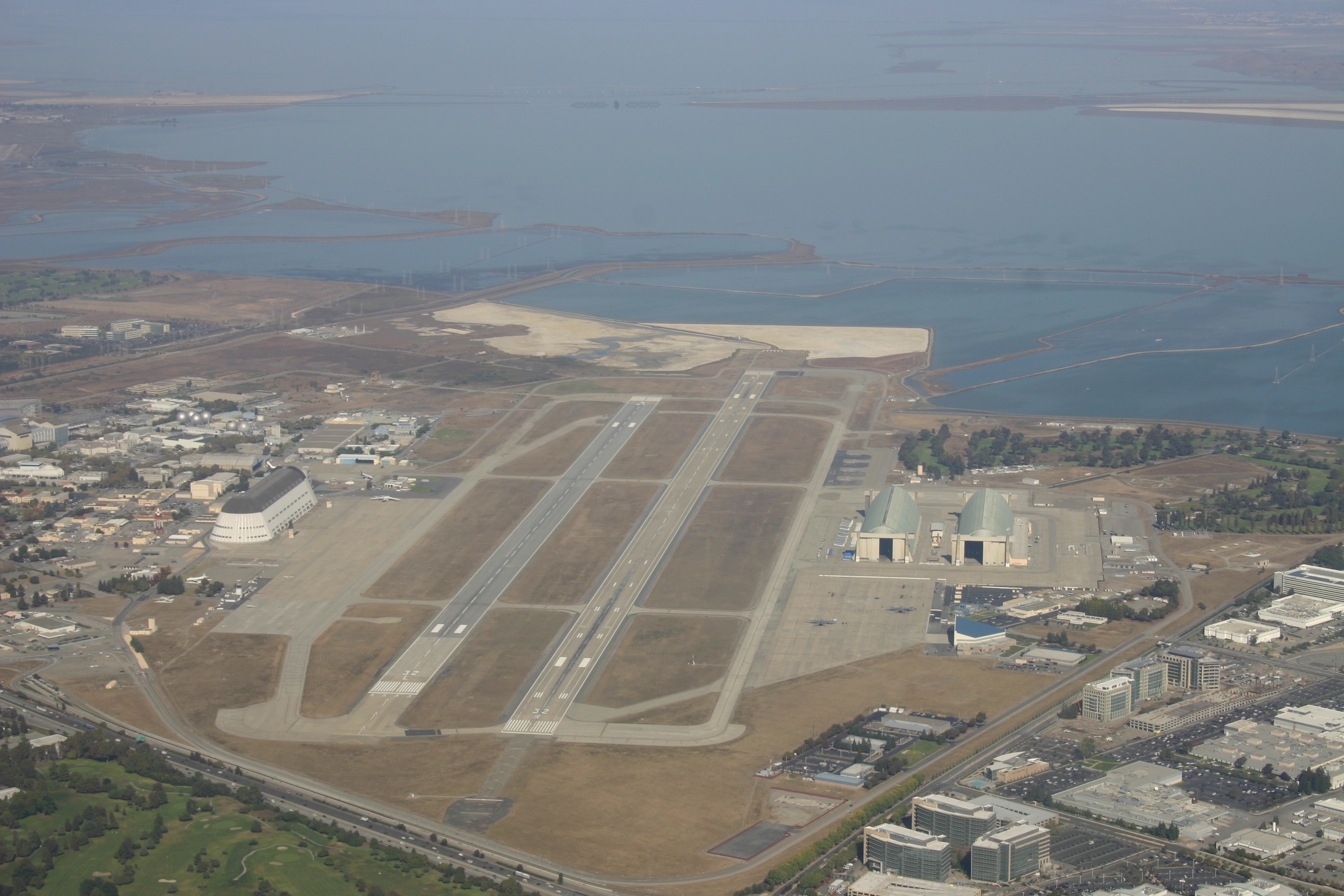
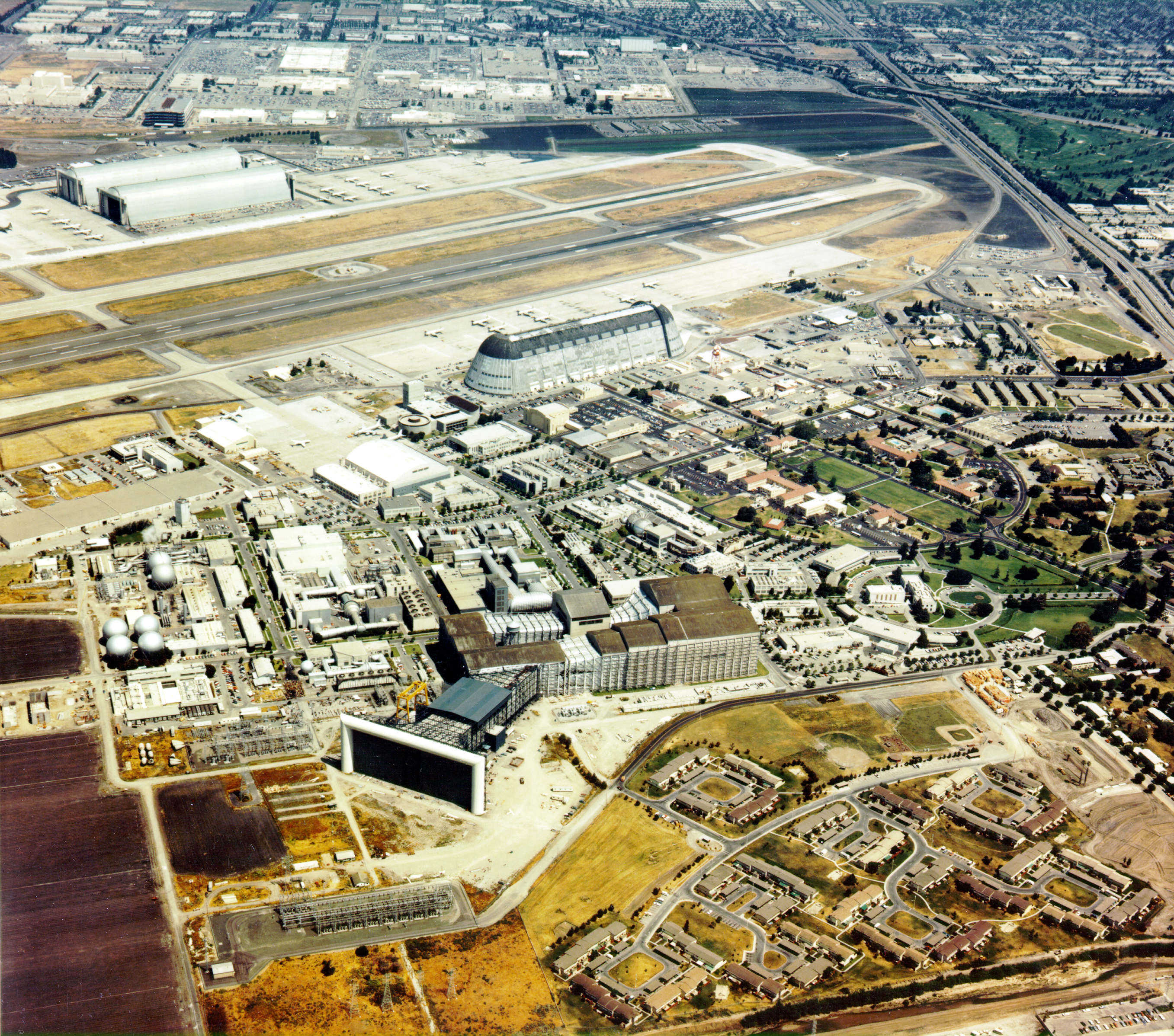
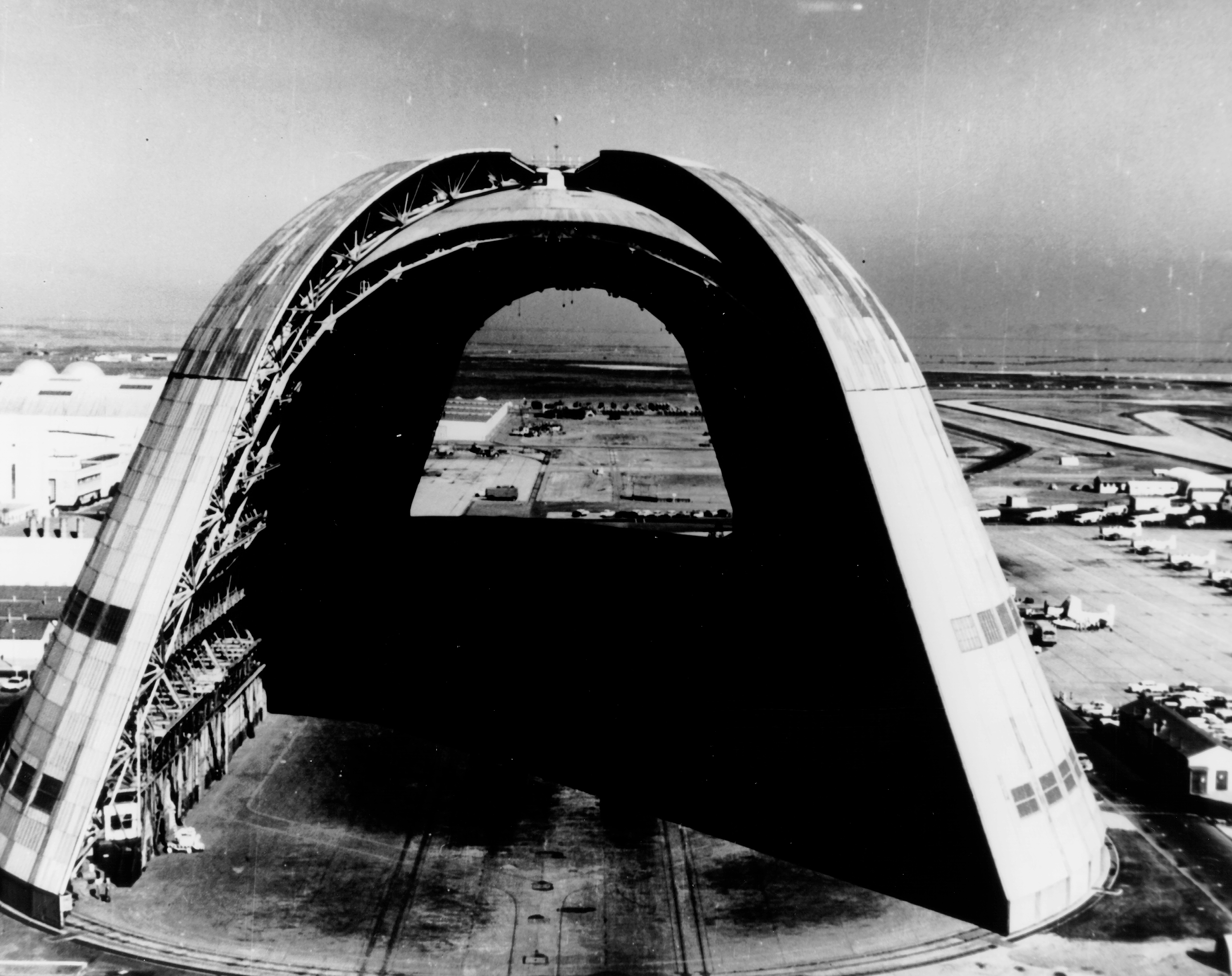
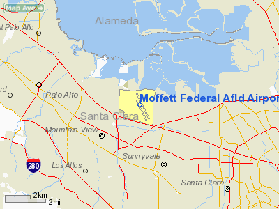
Moffett Federal Airfield (IATA: NUQ, ICAO: KNUQ), also known as Moffett Field, is a joint civil-military airport located 3 miles (5 km) north of downtown Mountain View, near Sunnyvale, California, USA. The airport is near the south end of San Francisco Bay, north of San Jose. Formerly a United States Navy facility, the former naval air station is now owned and operated by the NASA Ames Research Center. Tenant military activities include the 129th Rescue Wing of the California Air National Guard, operating the HC-130 Hercules, MC-130 Combat Shadow and HH-60 Pave Hawk aircraft, as well as the adjacent Onizuka Air Force Station and Headquarters for the 7th Psychological Operations Group of the U.S. Army Reserve. NASA also operates several aircraft from Moffett. By far the most famous and visible sites are hangars #1, #2, and #3, which dwarf the surrounding buildings. Hangar One is one of the world's largest freestanding structures, covering 8 acres (32,000 m). Hangars #2 and #3 are significant more for their size than their unique styling or design. Hangar One is a Naval Historical Monument and the entire airfield is a United States Registered Historic District. In May 2008, The National Trust for Historic Preservation listed Hangar One on their list of America's Most Endangered Places. The NASA Ames site is home to several wind tunnels, including the Unitary Plan Wind Tunnel (a National Historic Landmark), and the National Full-Scale Aerodynamic Complex (NFAC). HistoryIn 1931, the city of Sunnyvale acquired a 1,000 acre (4 km²) parcel of farmland bordering San Francisco Bay, then "sold" the parcel for $1 to the US government as a home base for the Navy airship USS Macon. The location proved to be ideal for an airport, since the area is often clear while other parts of the San Francisco Bay are covered in fog. This is due to the Coast Range to the west which blocks the cold oceanic air which is the cause of San Francisco fog. The base, originally named Airbase Sunnyvale CAL (it was thought that calling it Mountain View would cause officials to fear airships colliding with mountainsides), was accepted by the U.S. Navy on February 12, 1931 and dedicated NAS Sunnyvale on April 12, 1933. After the death of Rear Admiral William A. Moffett, who is credited with the creation of the airfield, in the loss of the USS Akron on April 4, 1933, the Naval Air Station was renamed NAS Moffett Field on September 1, 1933. After the ditching of the Macon on February 12, 1935, and until 1941, the Navy transferred claimancy of Moffett Field to the War Department and the installation was under the control of the U.S. Army Air Corps.
In 1941, control of the facility was returned to the Navy as NAS Moffett Field. From the end of World War II until its closure, NAS Moffett Field saw the development and use of several generations of land-based anti-submarine warfare and maritime patrol aircraft, including the Lockheed P2V Neptune and Lockheed P-3 Orion. Until the demise of the USSR and for some time thereafter, daily anti-submarine sorties flew out from Moffett Field to patrol along the Pacific coastline while Moffett's other squadrons and aircraft periodically deployed to other Pacific, Indian Ocean and Persian Gulf bases for periods of up to six months. In 1960, the nearby Air Force Satellite Test Center (STC), was created adjacent to (on the SW corner of) NAS Moffett Field. Often referred to as "the Blue Cube," it is operational today as Onizuka Air Force Station now part of the Air Force Satellite Control Network (AFSCN). In August 1986 during the Moffett Field NAS Airshow, the Italian demonstration team, Frecce Tricolori, performed as well as the German jet team, the Vikings, in front of the crowd. At its peak in the 1990s, NAS Moffett Field was the U.S. Navy's principal Pacific Fleet base for the P-3C operations. In addition to headquarters staffs for Commander, U.S. Patrol Wings Pacific Fleet (COMATWINGSPAC); Commader, Patrol Wing TEN (COMPATWING 10); and Commander, Reserve Patrol Wing Pacific / Patrol Wing FOUR (COMRESPATWINGPAC/COMPATWING 4), the air station also hosted Patrol Squadron THIRTY-ONE (VP-31)...the west coast P-3C Fleet Replacement Squadron, six additional active duty P-3C squadrons and a Naval Air Reserve P-3C squadron in addition to NASA and California Air National Guard aviation activities. Post-Cold War defense cutbacks and related Base Realignment and Closure (BRAC) actions in the 1990s identified NAS Moffett Field for closure. The west coast Fleet Replacement Squadron, Patrol Squadron THIRTY-ONE (VP-31), was deactivated and its functions combined with its east coast counterpart, Patrol Squadron THIRTY (VP-30) at NAS Jacksonville, Florida. Several active duty P-3C squadrons, the Naval Air Reserve P-3C squadron and COMRESPATWINGPAC/COMPATWING 4 were also deactivated, while COMPATWINGSPAC and COMPATWING 10 (redesignated COMPATRECONWING 10) transferred to NAS Whidbey Island, Washington while the remaining patrol squadrons transferred to NAS Whidbey Island, Washington or NAS Barbers Point, Hawaii (until its closure in 1999), at which time the Barbers Point squadrons moved to Marine Corps Air Facility Kaneohe Bay, Hawaii. On July 1, 1994, NAS Moffett Field was closed as a naval air station and turned over to the NASA Ames Research Center. NASA Ames now operates the facility as Moffett Federal Airfield. Since being decommissioned as a primary military installation, part of Moffett has been made accessible to the public, including a cordoned portion of the interior of the massive Hangar One. There were once balloon rides given on show days, and incidents of weather inside. Moffett Federal Airfield has moderate air traffic, with an average of 5-10 flights landing per day. Moffett is regularly used by the California Air National Guard, NASA, Lockheed Martin Space Systems (commercial satellite manufacturer), the Google founders for their private planes, Air Force One during presidential visits to the Bay Area as well as several other organizations. Hangar One
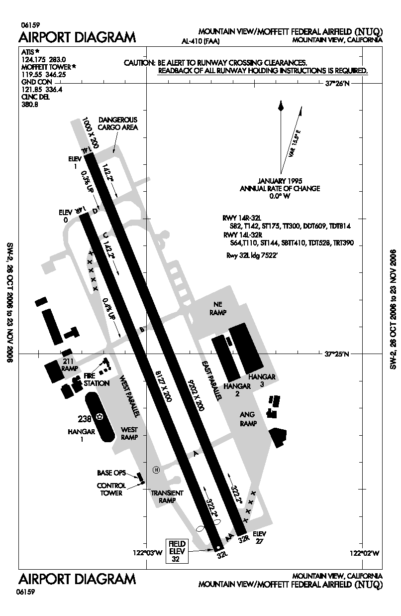
Moffett Field's "Hangar One" (built during the Depression era for the USS Macon) and the row of World War II blimp hangars are still some of the largest unsupported structures in the country. The airship hangar is constructed on a network of steel girders sheathed with galvanized steel. It rests firmly upon a reinforced pad anchored to concrete pilings. The floor covers eight acres (32,000 m²) and can accommodate 10 football fields. The airship hangar measures 1,133 feet (343 m) long and 308 feet (93 m) wide. The building has aerodynamic architecture. Its walls curve upward and inward, to form an elongated dome 198 feet (60 m) high. The clam-shell doors were designed to reduce turbulence when the Macon moved in and out on windy days. The "orange peel" doors, weighing 200 tons (204.75 tonnes) each, are moved by their own 150 horsepower motors operated via an electrical control panel. The airship hangar's interior is so large that fog sometimes forms near the ceiling. A person unaccustomed to its vastness is susceptible to optical disorientation. Looking across its deck, planes and tractors look like toys. Along its length maintenance shops, inspection laboratories and offices help keep the hangar busy. Looking up, a network of catwalks for access to all parts of the structure can be seen. Two elevators meet near the top, allowing maintenance personnel to get to the top quickly and easily. Narrow gauge tracks run through the length of the hangar. During the lighter-than-air period of dirigibles and non-rigid aircraft, the rails extended across the apron and into the fields at each end of the hangar. This tramway facilitated the transportation of an airship on the mooring mast to the airship hangar interior or to the flight position. During the brief period that the Macon was based at Moffett, Hangar One accommodated not only the giant airship but several smaller non-rigid lighter-than-air craft simultaneously. Hangar One today is the center of a spirited debate over its own future. Plans to convert it to a space and science center have been put on hold with the discovery in 2003 that the structure is leaking toxic chemicals into the sediment in wetlands bordering San Francisco bay. The chemicals originate in the lead paint and toxic materials, including polychlorinated biphenyls (PCBs), used to coat the hangar. The issue under debate is whether to tear down the hangar and reuse the land, or to clean the toxic waste from the site and refurbish the hangar for future preservation. The US Navy is evaluating options for remediating the PCBs, lead and asbestos. NASA is evaluating options for reuse of the hangar. Some historic and nonprofit groups would like the hangar preserved as a historic landmark, however, as the hangar is a major bay area landmark and historic site. In 2006, an offer to clean the hangar and coat its outsides with solar panels to recoup the costs of cleaning was floated by a private company, but the plan never saw fruition because it was too costly. In August 2008, the Navy proposed to simply strip the toxic coating from the hangar and leave the skeleton, after spraying it with a preservative. The Navy claimed that to reclad the structure would cost another $15 million and that this is NASA's responsibility. This was regarded as a partial victory by campaigners. In September 2008, NASA indicated that it was still urging the Navy to restore the hangar, but that it is willing to help save the structure; in particular, NASA is in favor of re-covering the structure at the same time as it is stripped. An episode of the Discovery Channel TV show MythBusters utilized one of the smaller hangars to disprove the myth that it is not possible to fold a sheet of paper in half more than seven times. The sheet of paper covered nearly the full width of the airship hangar. Other episodes of Mythbusters have utilized the hangar to test myths such as "Inflating a football with helium allows longer kick distances" and "Airworthy aircraft can be constructed of concrete." FacilitiesDespite its closure as an active military base, Moffett Field still has many active facilities and residents. Active military families still live on Moffett Community Housing, and the former base has several lodges which primarily house academics and students associated with the Ames Research Center. Moffett Field's facilities available to residents include a pool, post office, golf course, tennis courts, gas station, and several small shops and restaurants, which until April 30, 2008 included an on-site McDonald's. Status of former military buildingsMany of the buildings at Moffett Field which once supported its active military presence have been abandoned and left standing due to asbestos contamination within the structures. AirfieldMoffett Field is an active airfield, and has two active runways:
University facilitiesMoffett Field also hosts four university branch campuses: Singularity University, San Jose State University's (SJSU) Metropolitan Technology Center, Carnegie Mellon Silicon Valley, and UC Santa Cruz. These are within the base primarily to support the academic and research collaboration between these institutions and NASA Ames. Private aircraftMoffett Airfield is home to the private jet owned by Google founders Larry Page and Sergey Brin. They pay $1.3 million a year to park their customized wide-body Boeing 767-200 and two other Gulfstream V jets owned by Google executives at the airfield, which is generally closed to private aircraft. The airplanes have had scientific equipment installed by NASA to allow for experiments to be run in flight. Community opposition to the use of the airfield for private purposes has blocked previous deals, including opening the field up to FedEx Express and UPS Airlines in the 1990s. Until 2008 only two other private groups - Lockheed Martin and a helicopter operator - had use of the airfield. In October 2008 the first Zeppelin airship to offer private flights in the United States since 1937's Hindenburg disaster became available for tours of the Bay Area and beyond. The 246-foot craft, operated by Airship Ventures, is housed in Hangar Two, was built in Germany and is the fourth modern airship constructed and the third to be put in public service. It was dedicated and given the name Eureka at the celebration of Moffett Field's 75th anniversary. Assigned units
Proposed site of Expo 2020Moffett Field has been proposed as the site of the 2020 World's Fair. Governor Arnold Schwarzenegger announced California's bid to host the 2020 international exposition in Silicon Valley while visiting Expo 2010 in Shanghai, China, on September 11. At that time, he revealed Moffett Field as the location for the event, if California won the bid to host. The above content comes from Wikipedia and is published under free licenses – click here to read more.
Runway InformationRunway 14L/32R
Runway 14R/32L
Radio Navigation Aids
Remarks
Based Aircraft
Moffett Federal Afld Airport Address: Alameda County, CA Tel: 415-604-0685, 650-604-0685 FAX (650) 604-3144 Images
and information placed above are from We thank them for the data!
We don't guarantee the information is fresh and accurate. The data may
be wrong or outdated. |
||||||||||||||||||||||||||||||||||||||||||||||||||||||||||||||||||||||||||||||||||||||||||||||||||||||||||||||||||||||||||||||||||||||||||||||||||||||||||||||||||||||||||||||||||||||||||||||||||||||||||||||||||||||||||||||||||||||||||||||||||||||||||||||||||||||||||||||||||||||||||||||||||||||||||||||||||||||||||||||||||||||||||||||||||||||||||||||||||

 |
|
Copyright 2004-2026 © by Airports-Worldwide.com, Vyshenskoho st. 36, Lviv 79010, Ukraine Legal Disclaimer |