|
|
Modesto City-co-harry Sham Field Airport |
Modesto City-County Airport
Harry Sham Field |
 |
| IATA: MOD – ICAO: KMOD – FAA LID: MOD |
| Summary |
| Airport type |
Public |
| Operator |
City of Modesto |
| Location |
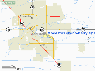
Modesto, California |
| Elevation AMSL |
97 ft / 29.6 m |
| Coordinates |
37°37′33″N 120°57′16″W / 37.62583°N 120.95444°W / 37.62583; -120.95444Coordinates: 37°37′33″N 120°57′16″W / 37.62583°N 120.95444°W / 37.62583; -120.95444 |
| Runways |
| Direction |
Length |
Surface |
| ft |
m |
| 10L/28R |
5,911 |
1,802 |
Asphalt |
| 10R/28L |
3,459 |
1,054 |
Asphalt |
Modesto City-County Airport (IATA: MOD, ICAO: KMOD, FAA LID: MOD), also known as Harry Sham Field, is located two miles (3 km) southeast of the central business district (CBD) of Modesto, a city in Stanislaus County, California, USA. History
Modesto City-County Airport (MOD) was the nation's first municipally-owned airport, opening for general aviation operation in 1918, At first the airport located southeast of downtown Modesto was only 82 acres (33 ha);and then relocated in 1929 to the current location. Over the years, it grew to its present size of 435 acres (176 ha). The airport started with only a single runway, but a second runway was added in the 1950s. During World War II, Modesto Airport was used as a military auxiliary airbase to train U.S. Air Corps pilots.
Originally, the airport was named Modesto Municipal Airport; and on May 25 1955 when Stanislaus County and the City of Modesto became partners in the airport, the airport was renamed Modesto City-County Airport. In October 1974, Harry Sham Field was added to the name to honor the airport manager that served between 1949 and 1968.
Air carrier service was first offered to the community in 1946 when United Airlines opened its newly constructed terminal and began the Valley Queen service. Since 1946, Modesto has had continuous air service. United Airlines provided service with either DC-3s or B-737s until 1978 when the airline industry was deregulated. Since 1978, Modesto has had regional air carrier’s service to San Francisco bay area airports.
On October 12, 1991, the Modesto City Council and Stanislaus Board of Supervisors rededicated the remodeled passenger terminal that was enlarged to 8,900 square feet (830 m). The remodeling project upgraded the building originally built by United Airlines.
In the 1990s, corporate and business aviation became the fastest growing segment of activity for the airport. Corporate jets provide their owners with convenient point-to-point service. In 2001, Modesto was the base for at least eight corporate jets. These aircraft have a combined appraised value of approximately $115.0 million, which brings the community approximately $1,115,000 in annual property taxes.
Mid-2006 saw a change to MOD Airport. United Express/SkyWest Airlines added four flights a day to/from LAX and an additional flight to SFO to total 5 flights a day to/from San Francisco. As a result, passenger counts have continued to grow. In 2002, passenger counts averaged 3,035 per month; over the first six months of 2007, that amount has grown to an average of 7,739 passengers per month.
In June 2008, Utah based Skywest Airlines (United Express) stopped service to Los Angeles citing high fuel prices as one reason for discontinuing service. In 2007 Modesto set a record number of boarding passengers with 51,587 taking flights from the airport.
Facilities
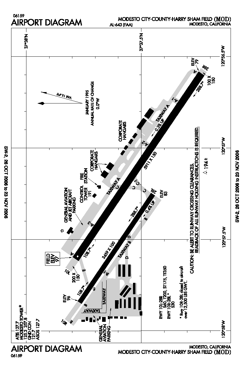
Modesto City-County Airport has two runways:
- Runway 10L/28R: 5,911 x 150 ft (1,802 x 46 m) asphalt, Pavements 60/200/400, HIRL, MALSR, PCL 9:00 p.m. - 7:00 a.m. (Freq 125.3) VASI - RW 10L.
- Runway 10R/28L: 3,459 x 100 ft (1,054 x 30 m) asphalt, Pavements 30/-/-, MIRL, not available when tower closed, PAPI - RW 10R/28L.
Airline and destinations
| Airlines |
Destinations |
| United Express operated by SkyWest Airlines |
San Francisco |
The above content comes from Wikipedia and is published under free licenses – click here to read more.
Location
& QuickFacts
|
FAA
Information Effective: |
2006-09-28 |
|
Airport
Identifier: |
MOD |
|
Longitude/Latitude: |
120-57-15.9170W/37-37-32.9420N
-120.954421/37.625817 (Estimated) |
|
Elevation: |
97 ft / 29.57 m (Surveyed) |
|
Land: |
435 acres |
|
From
nearest city: |
2 nautical miles SE of Modesto, CA |
|
Location: |
Stanislaus County, CA |
|
Magnetic Variation: |
16E (1985) |
Owner
& Manager
|
Ownership: |
Publicly owned |
|
Owner: |
City Of Modesto |
|
Address: |
Po Box 642
Modesto, CA 95353 |
|
Phone number: |
209-577-5318 |
|
Manager: |
Howard L Cook |
|
Address: |
Box 642
Modesto, CA 95353 |
|
Phone number: |
209-577-5318 |
Airport
Operations and Facilities
|
Airport
Use: |
Open to public |
|
Wind
indicator: |
Yes |
|
Segmented
Circle: |
Yes |
|
Control
Tower: |
Yes |
|
Attendance
Schedule: |
ALL/ALL/ALL |
|
Lighting
Schedule: |
DUSK-DAWN
MIRL RY 10R/28L AND PAPI RYS 10R & 28L UNAVBL WHEN ATCT
CLSD. |
|
Beacon
Color: |
Clear-Green (lighted land airport) |
|
Landing
fee charge: |
No
OVERNGT TIEDOWN FEE |
|
Sectional
chart: |
San Francisco |
|
Region: |
AWP - Western-Pacific |
|
Boundary
ARTCC: |
ZOA - Oakland |
|
Tie-in
FSS: |
RIU - Rancho Murieta |
|
FSS
on Airport: |
No |
|
FSS
Phone: |
916-354-0161 |
|
FSS
Toll Free: |
1-800-WX-BRIEF |
|
NOTAMs
Facility: |
MOD (NOTAM-d service avaliable) |
|
Certification
type/date: |
I AU 5/1973
PPR 48 HRS FOR ACR OPNS WITH MORE THAN 30 PSGR SEATS 0800-1700
WKDAYS CALL AMGR (209) 577-5318. |
|
Federal Agreements: |
NGY |
Airport
Communications
|
CTAF: |
125.300 |
|
Unicom: |
122.950 |
Airport
Services
|
Fuel
available: |
100LL80 A A1+ |
|
Airframe
Repair: |
MAJOR |
|
Power
Plant Repair: |
MAJOR |
|
Bottled
Oxygen: |
NONE |
|
Bulk
Oxygen: |
HIGH/LOW |
|
Runway Information
Runway 10L/28R
|
Dimension: |
5911 x 150 ft / 1801.7 x 45.7 m |
|
Surface: |
ASPH, Good Condition |
|
Surface
Treatment: |
Saw-cut or plastic Grooved |
|
Weight
Limit: |
Single wheel: 60000 lbs.
Dual wheel: 200000 lbs.
Dual tandem wheel: 350000 lbs.
< LBS 12500 OVER ACFT TO CLSD
10R-28L> |
|
Edge
Lights: |
High |
|
|
Runway 10L |
Runway 28R |
|
Longitude: |
120-57-36.4520W |
120-56-35.6240W |
|
Latitude: |
37-37-47.0950N |
37-37-14.3160N |
|
Elevation: |
96.00 ft |
79.00 ft |
|
Alignment: |
124 |
127 |
|
ILS
Type: |
|
ILS |
|
Traffic
Pattern: |
Left |
Right |
|
Markings: |
Precision instrument, Good Condition |
Precision instrument, Good Condition |
|
Crossing
Height: |
50.00 ft |
0.00
ft |
|
VASI: |
4-box on left side |
|
|
Visual
Glide Angle: |
3.00� |
0.00� |
|
Approach
lights: |
|
MALSR |
|
Runway
End Identifier: |
Yes |
No |
|
Centerline
Lights: |
No |
No |
|
Touchdown
Lights: |
No |
No |
|
Obstruction: |
73 ft tree, 2700.0 ft from runway, 450 ft right
of centerline, 34:1 slope to clear |
14 ft road, 1600.0 ft from runway, 50:1 slope
to clear |
|
Runway 10R/28L
|
Dimension: |
3459 x 100 ft / 1054.3 x 30.5 m |
|
Surface: |
ASPH, Good Condition |
|
Weight
Limit: |
Single wheel: 30000 lbs.
< LBS 12500 OVER ACFT TO CLSD
10R-28L> |
|
Edge
Lights: |
Medium |
|
|
Runway 10R |
Runway 28L |
|
Longitude: |
120-57-50.5990W |
120-57-15.0110W |
|
Latitude: |
37-37-46.3540N |
37-37-27.1700N |
|
Elevation: |
96.00 ft |
83.00 ft |
|
Alignment: |
124 |
127 |
|
Traffic
Pattern: |
Right |
Left |
|
Markings: |
Basic, Good Condition |
Basic, Good Condition |
|
Crossing
Height: |
40.00 ft |
29.00 ft |
|
VASI: |
2-light PAPI on left side |
2-light PAPI on left side |
|
Visual
Glide Angle: |
3.50� |
3.00� |
|
Runway
End Identifier: |
No |
No |
|
Centerline
Lights: |
No |
No |
|
Touchdown
Lights: |
No |
No |
|
Obstruction: |
56 ft tree, 1340.0 ft from runway, 75 ft left
of centerline, 20:1 slope to clear
APCH RATIO 33:1 TO DSPLCD THR. |
47 ft tree, 1700.0 ft from runway, 50 ft right
of centerline, 31:1 slope to clear |
|
Radio Navigation
Aids
|
ID |
Type |
Name |
Ch |
Freq |
Var |
Dist |
|
TCY |
NDB |
Tracy |
|
203.00 |
15E |
23.7 nm |
|
LV |
NDB |
Reiga |
|
374.00 |
16E |
34.9 nm |
|
MOD |
VOR/DME |
Modesto |
093X |
114.60 |
17E |
0.2 nm |
|
HYP |
VOR/DME |
El Nido |
089X |
114.20 |
15E |
36.0 nm |
|
SJC |
VOR/DME |
San Jose |
088X |
114.10 |
16E |
49.6 nm |
|
ECA |
VORTAC |
Manteca |
107X |
116.00 |
17E |
16.2 nm |
|
LIN |
VORTAC |
Linden |
095X |
114.80 |
17E |
27.1 nm |
Remarks
- IN
THE INTEREST OF NOISE ABATEMENT: TUBO JETS DISCONTINUE OPNS 2400-0500
LCL & PARK ON NE RAMP.
-
< RAMP
NE AT SVC AND PRKG LMTD LARGE JET PURE>
- BIRDS
ON AND IN VICINITY OF ARPT.
- AVIATION
WX AVBL WHEN ATCT OPNL CALL 209-526-4555.
- MIRL
RY 10R/28L AND PAPI RY 10R & 28L UNAVBL WHEN TWR CLSD.
- NOISE
ABATEMENT PROCEDURES: PILOTS ARE REQUESTED TO USE LGTD RWY ONLY.
- RWY
10R/28L NOT CERTIFICATED FOR FAR-139.
Based Aircraft
|
Aircraft
based on field: |
176 |
|
Single
Engine Airplanes: |
148 |
|
Multi
Engine Airplanes: |
22 |
|
Jet Engine
Airplanes: |
2 |
|
Helicopters: |
4 |
Major Carriers
Serving This Airport
Most Popular Destinations
| San Francisco Intl (SFO) |
100.0% |
Most Popular Aircraft
|
N234SW |
4.5% |
| N292SW |
3.9% |
|
N288SW |
3.9% |
| N289YV |
3.4% |
|
N223SW |
3.4% |
| N561SW |
3.4% |
|
N299SW |
3.4% |
| N226SW |
3.4% |
|
N227SW |
3.1% |
| N296SW |
2.8% |
Operational Statistics
|
Aircraft
Operations: |
252/Day |
|
Air Taxi: |
17.8% |
|
General
Aviation Local: |
30.7% |
|
General
Aviation Itinerant: |
50.7% |
|
Military: |
0.8% |
Modesto City-co-harry Sham Fld Airport
Address:
Stanislaus County, CA
Tel:
209-577-5318
Images
and information placed above are from
http://www.airport-data.com/airport/MOD/
We
thank them for the data!
| General
Info |
| Country |
United
States |
| State |
CALIFORNIA
|
| FAA ID |
MOD
|
| Latitude |
37-37-32.942N
|
| Longitude |
120-57-15.917W
|
| Elevation |
97 feet
|
| Near City |
MODESTO
|
We don't guarantee the information is fresh and accurate. The data may
be wrong or outdated.
For more up-to-date information please refer to other sources.
|
|