|
 |
|
||||
|
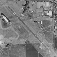
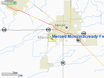
Merced Regional Airport (IATA: MCE, ICAO: KMCE, FAA LID: MCE), also known as MacReady Field, is a public airport located two miles (3 km) southwest of the central business district of Merced, a city in Merced County, California, United States. The airport is owned by the City of Merced. It is mostly used for general aviation, but is also used by one commercial airline. Service is subsidized by the Essential Air Service program. On April 7, 2010, Great Lakes Airlines commenced service to McCarran International Airport in Las Vegas, Nevada. The airline offers two daily non-stop, round trip flights between Merced and Las Vegas. Previously, Great Lakes Airlines provided service to LA/Ontario International Airport in Ontario, California. Due to the success of flights to Las Vegas offered under prior carriers, service between Merced and Ontario was discontinued in favor of the more popular Las Vegas route. Bus connections to Yosemite National Park are available through the Yosemite Area Regional Transportation System (YARTS). History
Merced Regional Airport began its existence at what is now the present day site of Castle Airport in nearby Atwater, CA. The airstrip along with sixty-six acres of land was obtained in 1932 as a gift from the Twenty-Thirty Club and the Crocker-Huffman Company, and in 1936 the City of Merced assumed responsibility of the airport. During the next 5 years, several buildings were constructed and the airport site was expanded to 123 acres. After the United States entered World War II, Merced Municipal Airport was leased to the U.S. Army Air Force, eventually becoming Merced Army Airfield (1943-1946), and later Castle Air Force Base (1947-1995). Construction of a new airport at the present day site located about 2 miles southeast of Merced near Childs Avenue began in 1940. When the United States entered World War II, the remaining work was completed by the United States Army Corps of Engineers working under the Civil Aeronautics Authority. This new airport was known as "New Merced Municipal Airport". In 1943, the new airport was leased to the U.S. Army Air Force and used as an axillary field for Merced Army Airfield (present day Castle Airport). Under the lease, the airport's name was changed to "New Merced Municipal Airport Auxiliary Field". The lease was terminated immediately after the war, and the airport was returned to civil control. In 1946, United Airlines began operations at the airport, constructing offices and a terminal building. That same year, damage incurred during the Army Air Force's use of the site was repaired, and additional improvements to the airport were completed using government funds. Two years later in 1948, Merced Municipal Airport was annexed to the City of Merced. During the 1950s, the airport was used to service military aircraft from the United States Armed Forces, and in 1975 a control tower was constructed to handle additional air traffic. On March 6, 2009 the city council voted to change the name of the airport from Merced Municipal Airport to Merced Regional Airport. The Airport has formerly been served by Air Pacific, American Eagle, Golden Gate Airlines, United Express and US Airways Express Facilities and aircraftMerced Regional Airport covers an area of 766 acres (310 ha) which contains one asphalt paved runway (12/30) measuring 5,914 x 150 ft (1,803 x 46 m). For the 12-month period ending December 31, 2009, the airport had 53,250 aircraft operations, an average of 146 per day: 94% general aviation, 5% scheduled commercial, and less than 1% military and air taxi. There are 80 aircraft based at this airport: 94% single engine, 6% multi-engine, and no jet aircraft. Merced Regional Airport also serves as a base for Medi-Flight Northern California, an air ambulance service provided by Mercy Air, a subsidiary of Air Methods. Medi-Flight shuttles critical patients from Mercy Medical Center Merced to hospitals in the Modesto and Fresno areas, as well as responding directly to accident scenes. Airline and destinations
Fly-InSince June 1957, Merced Regional Airport has hosted the annual Merced West Coast Antique Fly-In. Each year, the fly-in draws hundreds of pilots from across the Western United States to Merced to display their rare and antique aircraft. The fly-in also features an air show and an antique car show. In 2007, the 50th annual fly-in drew nearly 400 planes as well as several stunt pilots. Since 2008, the Merced West Coast Antique Fly-In has been canceled due to lack of sponsors and volunteers. Pilots wanting to participate in the fly-in are still welcomed to congregate at the airport. However, this gathering is unofficial and given limited publicity. The above content comes from Wikipedia and is published under free licenses – click here to read more.
Runway InformationRunway 12/30
Radio Navigation Aids
Remarks
Based Aircraft
Operational Statistics
Merced Muni/macready Field Airport Address: Merced County, CA Tel: 209-385-6834, 209-385-6873 Images
and information placed above are from We thank them for the data!
We don't guarantee the information is fresh and accurate. The data may
be wrong or outdated. |
||||||||||||||||||||||||||||||||||||||||||||||||||||||||||||||||||||||||||||||||||||||||||||||||||||||||||||||||||||||||||||||||||||||||||||||||||||||||||||||||||||||||||||||||||||||||||||||||||||||||||||||||||||||||||||||||||||||||||||||||||||||||||||||||||||||||||||||||||||||||||||||||||||||||||||||||||||||||||||||||||||||||||||||||

 |
|
Copyright 2004-2024 © by Airports-Worldwide.com, Vyshenskoho st. 36, Lviv 79010, Ukraine Legal Disclaimer |