 |
|
| Marina Municipal Airport |
| IATA: OAR – ICAO: KOAR – FAA LID: OAR |
| Summary |
| Airport type |
Public |
| Owner |
City of Marina |
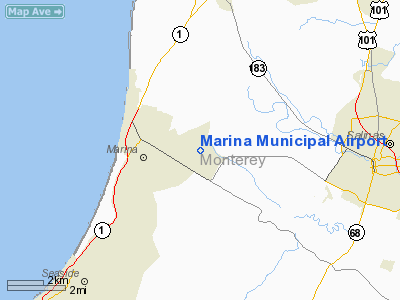
| Location |
Marina, California |
| Elevation AMSL |
137 ft / 42 m |
| Coordinates |
36°40′53″N 121°45′42″W / 36.68139°N 121.76167°W / 36.68139; -121.76167 |
| Runways |
| Direction |
Length |
Surface |
| ft |
m |
| 11/29 |
3,483 |
1,062 |
Asphalt |
| Statistics (2006) |
| Aircraft operations |
40,000 |
| Based aircraft |
69 |
| Source: Federal Aviation Administration |
Marina Municipal Airport (IATA: OAR, ICAO: KOAR, FAA LID: OAR) is a public airport located two miles (3 km) east of the central business district of Marina, a city in Monterey County, California, United States. It is owned by the City of Marina.
The airport is on the former site of the Fritzsche Army Air Field, built in the early 1960s at Fort Ord, which closed in 1994.
The Naval Postgraduate School, based in the nearby city of Monterey, has a Center for Interdisciplinary Remotely-Piloted Aircraft Studies (NPS/CIRPAS) at this airport.
Facilities and aircraft
Marina Municipal Airport has one asphalt paved runway (11/29) measuring 3,483 x 75 ft. (1,062 x 23 m).
For the 12-month period ending August 31, 2006, the airport had 40,000 aircraft operations, an average of 109 per day, all of which were general aviation. There are 69 aircraft based at this airport: 87% single engine, 6% multi-engine, 3% helicopters and 4% ultralight.
The above content comes from Wikipedia and is published under free licenses – click here to read more.
|
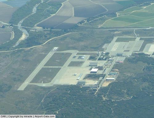 |
(Click on the photo to enlarge) |
Location
& QuickFacts
|
FAA
Information Effective: |
2006-09-28 |
|
Airport
Identifier: |
OAR |
|
Longitude/Latitude: |
121-45-44.4510W/36-40-54.7620N
-121.762348/36.681878 (Estimated) |
|
Elevation: |
134 ft / 40.84 m (Surveyed) |
|
Land: |
0 acres |
|
From
nearest city: |
2 nautical miles E of Marina, CA |
|
Location: |
Monterey County, CA |
|
Magnetic Variation: |
15E (1985) |
Owner
& Manager
|
Ownership: |
Publicly owned |
|
Owner: |
City Of Marina |
|
Address: |
211 Hillcrest Ave.
Marina, CA 93933 |
|
Phone number: |
831-384-3715 |
|
Manager: |
Steve Johnston |
|
Address: |
211 Hillcrest Ave.
Marina, CA 93933 |
|
Phone number: |
831-582-0102 |
Airport
Operations and Facilities
|
Airport
Use: |
Open to public |
|
Wind
indicator: |
Yes |
|
Segmented
Circle: |
Yes |
|
Control
Tower: |
No |
|
Attendance
Schedule: |
ALL/ALL/0800-1700 |
|
Lighting
Schedule: |
DUSK-DAWN
ACTVT MIRL RY 11/29 - CTAF. |
|
Beacon
Color: |
Clear-Green (lighted land airport) |
|
Sectional
chart: |
San Francisco |
|
Region: |
AWP - Western-Pacific |
|
Traffic
Pattern Alt: |
1000 ft |
|
Boundary
ARTCC: |
ZOA - Oakland |
|
Tie-in
FSS: |
OAK - Oakland |
|
FSS
on Airport: |
No |
|
FSS
Phone: |
510-273-6111 |
|
FSS
Toll Free: |
1-800-WX-BRIEF |
|
NOTAMs
Facility: |
OAK (NOTAM-d service avaliable) |
|
Federal Agreements: |
N |
Airport
Communications
|
CTAF: |
122.700 |
|
Unicom: |
122.700 |
Airport
Services
|
Fuel
available: |
100LL
FUEL AVBL 24 HRS VIA CREDIT CARD LOCK SYS. |
|
Airframe
Repair: |
MAJOR |
|
Power
Plant Repair: |
MAJOR |
|
Bottled
Oxygen: |
HIGH/LOW |
|
Runway Information
Runway 11/29
|
Dimension: |
3000 x 75 ft / 914.4 x 22.9 m |
|
Surface: |
ASPH, |
|
Weight
Limit: |
Single wheel: 20000 lbs. |
|
Edge
Lights: |
Medium |
|
|
Runway 11 |
Runway 29 |
|
Longitude: |
121-45-59.9410W |
121-45-28.9620W |
|
Latitude: |
36-41-02.7740N |
36-40-46.7500N |
|
Elevation: |
135.00 ft |
135.00 ft |
|
Alignment: |
122 |
127 |
|
Traffic
Pattern: |
Left |
Right |
|
Markings: |
Basic, Fair Condition |
Basic, Fair Condition |
|
Radio Navigation
Aids
|
ID |
Type |
Name |
Ch |
Freq |
Var |
Dist |
|
PDG |
NDB |
Pajar |
|
327.00 |
17E |
14.1 nm |
|
UAD |
NDB |
Chualar |
|
263.00 |
16E |
18.0 nm |
|
NUQ |
TACAN |
Moffett |
123X |
|
17E |
47.3 nm |
|
SJC |
VOR/DME |
San Jose |
088X |
114.10 |
16E |
42.6 nm |
|
SNS |
VORTAC |
Salinas |
120X |
117.30 |
17E |
7.7 nm |
|
BSR |
VORTAC |
Big Sur |
087X |
114.00 |
16E |
30.6 nm |
|
PXN |
VORTAC |
Panoche |
073X |
112.60 |
16E |
47.4 nm |
|
OSI |
VORTAC |
Woodside |
086X |
113.90 |
17E |
49.4 nm |
Remarks
- WILDLIFE
INVOF RY 11/29.
- DEP
RY 29 EXECUTE 45 DEGREE RIGHT TURN TO AVOID OVERFLIGHT OF NOISE SENSITIVE
RESIDENTIAL AREA.
- RY
29 CALM WIND RY.
- ULTRALIGHT
ACTIVITY ON AND INVOF ARPT.
- SKYDIVING
ACTIVITY ON SE SIDE OF AIRPORT
- PAEW
VCNTY OF RAMPS AND TWYS INDEFLY.
Based Aircraft
|
Aircraft
based on field: |
65 |
|
Single
Engine Airplanes: |
56 |
|
Multi
Engine Airplanes: |
4 |
|
Helicopters: |
2 |
|
Ultralights: |
3 |
Operational Statistics
|
Aircraft
Operations: |
110/Day |
|
General
Aviation Local: |
32.5% |
|
General
Aviation Itinerant: |
67.5% |
Marina Municipal Airport
Address:
Monterey County, CA
Tel:
831-384-3715, 831-582-010
Images
and information placed above are from
http://www.airport-data.com/airport/OAR/
We
thank them for the data!
| General
Info |
| Country |
United
States |
| State |
CALIFORNIA
|
| FAA ID |
OAR
|
| Latitude |
36-40-54.762N
|
| Longitude |
121-45-44.451W
|
| Elevation |
134 feet
|
| Near City |
MARINA
|
We don't guarantee the information is fresh and accurate. The data may
be wrong or outdated.
For more up-to-date information please refer to other sources.
|
|


