 |
|
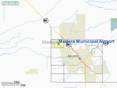
| Madera Municipal Airport |
| IATA: MAE – ICAO: KMAE |
| Summary |
| Airport type |
Public |
| Location |
Madera, California |
| Elevation AMSL |
255 ft / 78 m |
| Coordinates |
36°59′19.0″N 120°06′44.8″W / 36.98861°N 120.112444°W / 36.98861; -120.112444Coordinates: 36°59′19.0″N 120°06′44.8″W / 36.98861°N 120.112444°W / 36.98861; -120.112444 |
| Runways |
| Direction |
Length |
Surface |
| ft |
m |
| 12/30 |
5,545 |
1,690 |
Asphalt |
| 7/25 |
3,702 |
1,128 |
Asphalt |
Madera Municipal Airport (FAA LID: C83) is a public airport located three miles (4.8 km) northwest of Madera, serving Madera County, California, USA. The airport has two runways and is mostly used for general aviation.
Facilities
Madera Municipal Airport has two runways:
- Runway 12/30: 5,545 x 150 ft (1,690 x 46 m). Surface: Asphalt
- Runway 7/25: 3,702 x 150 ft (1,128 x 46 m). Surface: Asphalt
The above content comes from Wikipedia and is published under free licenses – click here to read more.
Location
& QuickFacts
|
FAA
Information Effective: |
2006-09-28 |
|
Airport
Identifier: |
MAE |
|
Longitude/Latitude: |
120-06-44.8000W/36-59-19.0000N
-120.112444/36.988611 (Estimated) |
|
Elevation: |
255 ft / 77.72 m (Surveyed) |
|
Land: |
524 acres |
|
From
nearest city: |
3 nautical miles NW of Madera, CA |
|
Location: |
Madera County, CA |
|
Magnetic Variation: |
16E (1980) |
Owner
& Manager
|
Ownership: |
Publicly owned |
|
Owner: |
City Of Madera |
|
Address: |
205 West 4th St
Madera, CA 93637 |
|
Phone number: |
559-661-5400 |
|
Manager: |
Sam Scheider |
|
Address: |
4020 Aviation Dr
Madera, CA 93637 |
|
Phone number: |
559-674-6958 |
Airport
Operations and Facilities
|
Airport
Use: |
Open to public |
|
Wind
indicator: |
Yes |
|
Segmented
Circle: |
Yes |
|
Control
Tower: |
No |
|
Attendance
Schedule: |
ALL/MON-FRI/0700-1630 |
|
Lighting
Schedule: |
DUSK-DAWN
ACTVT MIRL RY 12/30; PAPI RYS 12 & 30, REIL RY 30 AND
WIND TEE - CTAF. |
|
Beacon
Color: |
Clear-Green (lighted land airport) |
|
Landing
fee charge: |
No |
|
Sectional
chart: |
San Francisco |
|
Region: |
AWP - Western-Pacific |
|
Traffic
Pattern Alt: |
1000 ft |
|
Boundary
ARTCC: |
ZOA - Oakland |
|
Tie-in
FSS: |
RIU - Rancho Murieta |
|
FSS
on Airport: |
No |
|
FSS
Phone: |
916-354-0161 |
|
FSS
Toll Free: |
1-800-WX-BRIEF |
|
NOTAMs
Facility: |
MAE (NOTAM-d service avaliable) |
|
Federal Agreements: |
NGRY |
Airport
Communications
|
CTAF: |
122.800 |
|
Unicom: |
122.800 |
Airport
Services
|
Fuel
available: |
100LL80 A
FUEL AVBL 24 HRS WITH AUTOMATED CREDIT CARD. NO SINGLE POINT
PRESSURE REFUELING AVBL. |
|
Airframe
Repair: |
MAJOR |
|
Power
Plant Repair: |
MAJOR |
|
Bottled
Oxygen: |
NONE |
|
Bulk
Oxygen: |
NONE |
|
Runway Information
Runway 07/25
|
Dimension: |
3702 x 150 ft / 1128.4 x 45.7 m |
|
Surface: |
ASPH, Fair Condition |
|
Weight
Limit: |
Single wheel: 30000 lbs. |
|
|
Runway 07 |
Runway 25 |
|
Longitude: |
120-07-09.2510W |
120-06-23.6270W |
|
Latitude: |
36-59-00.1470N |
36-59-00.1330N |
|
Elevation: |
244.00 ft |
253.00 ft |
|
Alignment: |
90 |
127 |
|
Traffic
Pattern: |
Right |
Left |
|
Markings: |
Nonstandard, Fair Condition
/25 MARKED RESTRICTED. |
Nonstandard, Fair Condition |
|
Runway 12/30
|
Dimension: |
5545 x 150 ft / 1690.1 x 45.7 m |
|
Surface: |
ASPH, Fair Condition |
|
Weight
Limit: |
Single wheel: 30000 lbs. |
|
Edge
Lights: |
Medium |
|
|
Runway 12 |
Runway 30 |
|
Longitude: |
120-07-08.9732W |
120-06-20.6676W |
|
Latitude: |
36-59-38.3497N |
36-58-59.5717N |
|
Elevation: |
250.00 ft |
255.00 ft |
|
Alignment: |
127 |
127 |
|
Traffic
Pattern: |
Right |
Left |
|
Markings: |
Non-precision instrument, Fair Condition |
Non-precision instrument, Fair Condition |
|
Crossing
Height: |
34.00 ft |
34.00 ft |
|
VASI: |
2-light PAPI on left side |
2-light PAPI on left side |
|
Visual
Glide Angle: |
3.00� |
3.00� |
|
Runway
End Identifier: |
|
Yes |
|
Obstruction: |
, 50:1 slope to clear |
16 ft road, 380.0 ft from runway, 275 ft left
of centerline, 11:1 slope to clear
OBSTN CLNC SLOPE 20:1 TO EOR. |
|
Radio Navigation
Aids
|
ID |
Type |
Name |
Ch |
Freq |
Var |
Dist |
|
FCH |
NDB |
Chandler |
|
344.00 |
15E |
20.8 nm |
|
CUK |
NDB |
Academy |
|
266.00 |
14E |
27.7 nm |
|
NLC |
TACAN |
Lemoore |
080X |
|
16E |
39.4 nm |
|
HYP |
VOR/DME |
El Nido |
089X |
114.20 |
15E |
19.6 nm |
|
VIS |
VOR/DME |
Visalia |
031X |
109.40 |
16E |
48.1 nm |
|
CZQ |
VORTAC |
Clovis |
076X |
112.90 |
15E |
15.6 nm |
|
FRA |
VORTAC |
Friant |
103X |
115.60 |
17E |
25.8 nm |
|
PXN |
VORTAC |
Panoche |
073X |
112.60 |
16E |
36.0 nm |
Remarks
- RWY
07/25 RSTRD FOR AGRICULTURE USE ONLY.
- PARACHUTE
JUMPING ON ARPT.
Based Aircraft
|
Aircraft
based on field: |
120 |
|
Single
Engine Airplanes: |
98 |
|
Multi
Engine Airplanes: |
12 |
|
Jet Engine
Airplanes: |
1 |
|
Helicopters: |
1 |
|
Ultralights: |
8
ULTRALIGHT ACTIVITY ON AND IN VICINITY OF ARPT; ULTRALIGHT FLY PATTERN
500' AGL NE OF RWY 12/30. |
Operational Statistics
|
Aircraft
Operations: |
139/Day |
|
Air Taxi: |
0.7% |
|
General
Aviation Local: |
74.8% |
|
General
Aviation Itinerant: |
24.3% |
|
Military: |
0.2% |
Madera Municipal Airport
Address:
Madera County, CA
Tel:
559-661-5400, 559-674-6958
Images
and information placed above are from
http://www.airport-data.com/airport/MAE/
We
thank them for the data!
| General
Info |
| Country |
United
States |
| State |
CALIFORNIA
|
| FAA ID |
MAE
|
| Latitude |
36-59-08.583N
|
| Longitude |
120-06-43.144W
|
| Elevation |
253 feet
|
| Near City |
MADERA
|
We don't guarantee the information is fresh and accurate. The data may
be wrong or outdated.
For more up-to-date information please refer to other sources.
|
|


