 |
|
Lonnie Pool Field Weaverville Airport |
Weaverville Airport
Lonnie Pool Field |
| IATA: none – ICAO: none – FAA LID: O54 |
| Summary |
| Airport type |
Public |
| Operator |
Trinity County |
| Location |
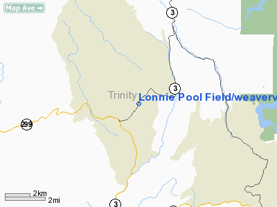
Weaverville, California |
| Elevation AMSL |
2,350 ft / 716.3 m |
| Coordinates |
40°44′45″N 122°55′19″W / 40.74583°N 122.92194°W / 40.74583; -122.92194Coordinates: 40°44′45″N 122°55′19″W / 40.74583°N 122.92194°W / 40.74583; -122.92194 |
| Runways |
| Direction |
Length |
Surface |
| ft |
m |
| X/36 |
2,980 |
908 |
Asphalt |
| DUE TO STEEP RUNWAY INCLINE, USE RUNWAY 36 FOR ALL FLIGHT OPERATIONS |
Weaverville Airport (FAA LID: O54), also known as Lonnie Pool Field, is a public airport located one mile (1.6 km) northeast of Weaverville, serving Trinity County, California, USA. This general aviation airport covers 65 acres and has one runway.
The above content comes from Wikipedia and is published under free licenses – click here to read more.
Location
& QuickFacts
|
FAA
Information Effective: |
2006-09-28 |
|
Airport
Identifier: |
O54 |
|
Longitude/Latitude: |
122-55-19.0920W/40-44-44.5200N
-122.921970/40.745700 (Estimated) |
|
Elevation: |
2350 ft / 716.28 m (Estimated) |
|
Land: |
65 acres |
|
From
nearest city: |
1 nautical miles NE of Weaverville, CA |
|
Location: |
Trinity County, CA |
|
Magnetic Variation: |
17E (1985) |
Owner
& Manager
|
Ownership: |
Publicly owned |
|
Owner: |
Trinity County |
|
Address: |
Po Box 476
Weaverville, CA 96093-0476 |
|
Phone number: |
530-623-1354 |
|
Manager: |
Wyatt Paxton |
|
Address: |
Po Box 476
Weaverville, CA 96093-0476 |
|
Phone number: |
530-623-1354 |
Airport
Operations and Facilities
|
Airport
Use: |
Open to public |
|
Wind
indicator: |
Yes |
|
Segmented
Circle: |
Yes |
|
Control
Tower: |
No |
|
Attendance
Schedule: |
UNATNDD |
|
Landing
fee charge: |
No |
|
Sectional
chart: |
Klamath Falls |
|
Region: |
AWP - Western-Pacific |
|
Traffic
Pattern Alt: |
800 ft |
|
Boundary
ARTCC: |
ZOA - Oakland |
|
Tie-in
FSS: |
RIU - Rancho Murieta |
|
FSS
on Airport: |
No |
|
FSS
Phone: |
916-354-0161 |
|
FSS
Toll Free: |
1-800-WX-BRIEF |
|
NOTAMs
Facility: |
RIU (NOTAM-d service avaliable) |
|
Federal Agreements: |
N |
Airport
Communications
|
CTAF: |
122.800 |
|
Unicom: |
122.800 |
Airport
Services
|
Bottled
Oxygen: |
NONE |
|
Bulk
Oxygen: |
NONE |
|
Runway Information
Runway 18/36
|
Dimension: |
2980 x 50 ft / 908.3 x 15.2 m |
|
Surface: |
ASPH, Good Condition |
|
Weight
Limit: |
Single wheel: 5000 lbs. |
|
|
Runway 18 |
Runway 36 |
|
Traffic
Pattern: |
Left |
Left |
|
Markings: |
Nonstandard, Fair Condition
NO NUMBERS MARKED; WHITE 'X' ON APCH END OF RY 18. |
Basic, Fair Condition |
|
Crossing
Height: |
0.00
ft |
40.00 ft |
|
Displaced
threshold: |
0.00
ft |
90.00 ft |
|
VASI: |
|
2-light PAPI on left side
RY 36 PAPI OTS INDEFLY. |
|
Visual
Glide Angle: |
0.00� |
3.00� |
|
Runway
End Identifier: |
No |
No |
|
Centerline
Lights: |
No |
No |
|
Touchdown
Lights: |
No |
No |
|
Obstruction: |
60 ft trees, 240.0 ft from runway
+15 FT ROAD 0 FT FROM RY END 60 FT LEFT. |
10 ft road, 200.0 ft from runway, 220 ft right
of centerline
RWY 36 APCH RATIO 30:1 FM DSPLCD THLD; APCH RATIO 20:1 OVER
45 FT TREE 935 FT FM DSPLCD THLD 230 FT RIGHT.
HWY 5-10 FT BELOW RY THR; 0-200 FT FROM RY THR 125 FT RIGHT
TO 25 FT RIGHT. |
|
Radio Navigation
Aids
|
ID |
Type |
Name |
Ch |
Freq |
Var |
Dist |
|
PBT |
NDB |
Proberta |
|
338.00 |
16E |
49.2 nm |
|
RDD |
VOR/DME |
Redding |
021X |
108.40 |
18E |
32.2 nm |
|
FJS |
VOR/DME |
Fort Jones |
033X |
109.60 |
19E |
42.6 nm |
|
RBL |
VORTAC |
Red Bluff |
104X |
115.70 |
18E |
50.0 nm |
Remarks
- ROAD
50 FT E OF CNTRLN AT RY 18 THR & 60 FT TREES IN PRIMARY SFC 80 FT
E OF RY CNTRLN.
- LND
RY 36 TKOF RY 18 DUE TO STEEP 3 1/2% UPHILL ARPT GRAD & STEEPER
RISING TRRN TO THE NORTH.
- ARPT
CLSD NIGHTS EXCP WITH PPR (530) 623-1365.
- ARPT
CLSD TO TOUCH & GO; GO AROUNDS; TKOF FM RY 36 & LDGS ON RY 18.
- ESTABD
PRIOR TO 15 MAY 1959.
Based Aircraft
|
Aircraft
based on field: |
15 |
|
Single
Engine Airplanes: |
15 |
Operational Statistics
|
Aircraft
Operations: |
270/Week |
|
General
Aviation Local: |
50.0% |
|
General
Aviation Itinerant: |
50.0% |
Lonnie Pool Field/weaverville Airport
Address:
Trinity County, CA
Tel:
530-623-1354
Images
and information placed above are from
http://www.airport-data.com/airport/O54/
We
thank them for the data!
| General
Info |
| Country |
United
States |
| State |
CALIFORNIA
|
| FAA ID |
O54
|
| Latitude |
40-44-44.520N
|
| Longitude |
122-55-19.092W
|
| Elevation |
2350 feet
|
| Near City |
WEAVERVILLE
|
We don't guarantee the information is fresh and accurate. The data may
be wrong or outdated.
For more up-to-date information please refer to other sources.
|
|


