|
|
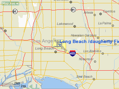
Long Beach (daugherty) Field Airport |
Long Beach Airport
Daugherty Field |
 |
| IATA: LGB – ICAO: KLGB – FAA LID: LGB
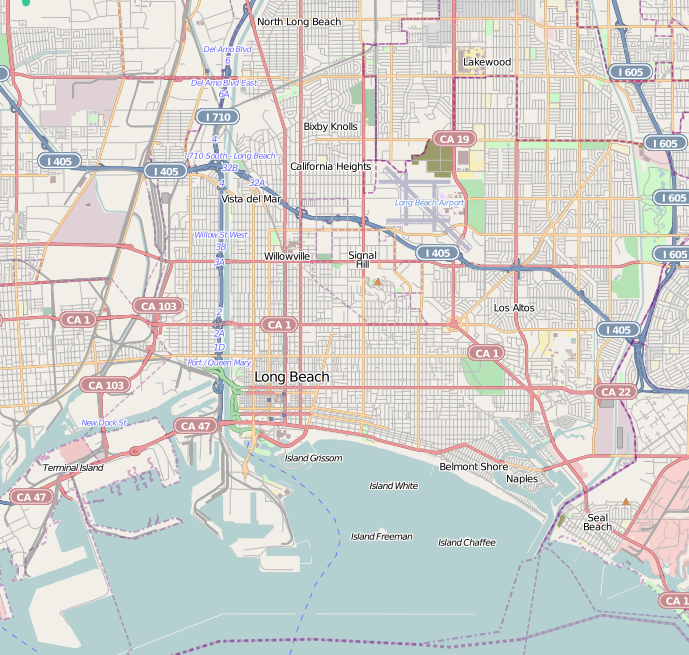
Location of the Long Beach Airport
|
| Summary |
| Airport type |
Public |
| Owner |
City of Long Beach |
| Serves |
Long Beach - Los Angeles - Orange/Los Angeles Counties - Multiple "SoCal" Cities. |
| Location |
Long Beach, California |
| Elevation AMSL |
60 ft / 18.3 m |
| Coordinates |
33°49′04″N 118°09′06″W / 33.81778°N 118.15167°W / 33.81778; -118.15167 |
| Website |
Long Beach Airport |
| Runways |
| Direction |
Length |
Surface |
| ft |
m |
| 12/30 |
10,000 |
3,048 |
Asphalt |
| 7L/25R |
6,192 |
1,887 |
Asphalt |
| 7R/25L |
5,423 |
1,653 |
Asphalt |
| 16L/34R |
3,975 |
1,211 |
Asphalt |
| 16R/34L |
4,470 |
1,362 |
Asphalt |
Long Beach Airport's terminal building. 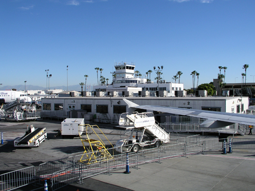 | |
Terminal building, other side. 2009. |
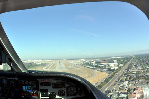 | |
Long Beach Airport runway 30 short final. |
Long Beach Airport (IATA: LGB, ICAO: KLGB, FAA LID: LGB), also known as Daugherty Field, is located in Long Beach, California, and serves Los Angeles and Orange Counties. The airport has four smaller runways and one long runway for jets (10,000 ft), plus nine taxiways, and occupies 1,166 acres (472 ha). It was formerly known as Long Beach Municipal Airport. Overview
Long Beach Airport has very little passenger service compared with the dominant Los Angeles International Airport (LAX) approximately 18 miles (29 km) to the northwest, and will always remain a relatively small airport because of restrictive ordinances adopted to minimize noise in the residential neighborhoods near LGB. The airport is under one of the strictest ordinances in the United States on both airport noise and the number of commercial flights. The current noise levels allow for 41 daily commercial flights and 25 commuter flights. Local community groups and activists are very vocal about any changes at the airport.
At the same time, the arrival of low-cost carrier JetBlue Airways at Long Beach Airport in 2001, and that airline's decision to establish a West Coast hub at LGB, has substantially increased the air traffic to the airport and has cemented LGB's standing as a viable alternative to LAX for flights from the Los Angeles area to major East Coast cities. While JetBlue used the local noise ordinance to turn Long Beach Airport into a miniature fortress hub, it quickly reached maximum capacity and has since been forced to rework flight schedules and direct future growth to other Los Angeles area airports. JetBlue calls LGB a Focus city
Air cargo carriers, including ABX Air (DHL), FedEx and UPS, also maintain operations out of LGB. 57,000 tons of goods are transported each year.
The Boeing Company (formerly McDonnell Douglas) maintains production of the C-17 military transport jet; maintenance facilities for other Boeing and McDonnell Douglas/Douglas aircraft (including the historic DC-9 and DC-10 aircraft) are also found at Long Beach Airport. Gulfstream Aerospace also has a completion center at the airport.
Although commercial flights are severely restricted, there are still a large number of flights at the airport from charter flights, private aviation, flight schools, law enforcement flights, helicopters, advertising blimps, planes towing advertising banners, etc. Because of that, Long Beach airport is one of the busiest general aviation airports in the world, with 398,433 aircraft movements in 2007.
Long Beach Airport has a single terminal. It is notable for its Streamline Moderne style of architecture and is a historical landmark. Because of the age and limited size of the current terminal, changes, including a possible addition, are currently under discussion (as of 2005).
Long Beach Transit Route 111 serves the airport. Wardlow Road runs from the airport to the Los Angeles County/Orange County border, where it becomes Ball Road and crosses the northern edge of the Disneyland Resort.
Long Beach Airport is the second closest airport to Disneyland, after John Wayne Airport.
Airlines and destinations
The gates at Long Beach Airport are divided into the North and South Concourse, each with four gates. Gates in the North Concourse are numbered 21, 22, 23A and 23B, while gates in the South Concourse are numbered 1, 2, 3, 4, and 4A.
| Airlines |
Destinations |
Concourse |
| Allegiant Air |
Bellingham, Colorado Springs, Idaho Falls [begins October 8], Stockton |
North |
| Delta Connection operated by SkyWest Airlines |
Salt Lake City |
North |
| Frontier Airlines |
Denver |
North |
| Frontier Airlines operated by Republic Airlines |
Denver |
North |
| Horizon Air |
Seattle/Tacoma |
North |
| JetBlue Airways |
Austin, Boston, Chicago-O'Hare, Fort Lauderdale, Las Vegas, New York-JFK, Oakland, Portland (OR), Sacramento, Salt Lake City, San Francisco, Seattle/Tacoma, Washington-Dulles |
South |
| US Airways Express operated by Mesa Airlines |
Phoenix |
North |
History
The first trans-continental flight, a biplane flown by Calbraith Perry Rodgers, landed in 1911 on Long Beach's sandy beach. From 1911 until the airport was created, planes continued to use the beach as a runway.
The famous barnstormer Earl S. Daugherty had leased the area that later became the airport for air shows, stunt flying, wing walking and passenger rides. Later, he started the world's first flight school in 1919 at the same location. In 1923, Daugherty convinced the City council to use the site to create the first municipal airport.
During the 1940s and 1950s the only airline nonstops were to Los Angeles, San Diego, and sometimes Catalina Island; in 1962 Western started one Electra flight a day to San Francisco. Jets arrived in 1968; in 1969 Western had nonstop 737s to Las Vegas, San Jose and San Francisco, but in 1980 SFO was the only nonstop jet destination (on PSA by then).
LGB was formerly served by both United Airlines and American Airlines; both pulled out because of a lack of profitability.
- Douglas "Wrong Way" Corrigan used to regularly fly out of Daugherty Field. Before his infamous flight from Brooklyn, New York to Ireland in 1938, he had already flown a transcontinental flight from Long Beach to New York. He was supposed to be returning to Daugherty Field after authorities had refused his request to fly on to Ireland, but because of a claimed navigational error, he ended up in Ireland instead. He never publicly acknowledged having flown to Ireland intentionally.
- The facade of Long Beach Airport's passenger terminal served as the fictional "Aeropuerto Val Verde" (Val Verde Airport) in the Arnold Schwarzenegger movie Commando (1985).
- The final scenes of the Cary Grant film The Bachelor and the Bobby-Soxer are set at Daugherty Field.
Military use
 | |
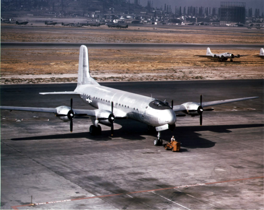
A Douglas C-74 Globemaster I at Long Beach Airport with Boeing B-17 and C-46 Curtiss Commando aircraft in the background. |
To attract the United States Navy, the City of Long Beach built a hangar and an administrative building and then offered to lease it to the Navy for $1 a year for the establishment of the Naval Reserve Air Base. On May 10, 1928, the U.S. Navy commissioned the field as a Naval Reserve Air Base (NRAB Long Beach). Two years later, the city built a hangar and administrative building for the United States Army Air Corps as well. It should be stated that the only significant developments to the little city airport began only after the city built hangars and administrative facilities for the Army and Navy in 1928-30.
As a Naval Reserve Air Base, the mission was to instruct, train and drill Naval Reserve aviation personnel. A ground school was offered three nights a week at the base and two nights a week at the University of California in Los Angeles until 1930, when ground school was continuously offered at the base. On April 9, 1939, training in night flight began, and shortly thereafter its facilities began to be used by fleet aircraft as well.
However, with increased air activity by commercial airlines and the private airplane industry, particularly with Douglas Aircraft showing an interest in the Long Beach Municipal Airport, the facility required more space. With Douglas Aircraft as a resident, the attitude of Long Beach's authorities became cold and openly hostile to naval aviation, with its city manager saying that "the sooner the Navy gets out of the Long Beach airport, the better we will like it."
Because of this hostile attitude, the Navy had begun a survey for a more suitable site — unknown to city officials at the time. Nevertheless, Admiral Ernest J. King, then the Chief of the Bureau of Aeronautics, and Admirals William D. Leahy, Joseph K. Taussig, and Allen E. Smith pointedly requested that the city of Long Beach repair the runways and reminded the city that the Pacific Fleet, then laying offshore in both Long Beach and San Pedro harbors, had a payroll of more than $1 million a month. Eventually the city complied with the Navy's requests.
Still, the city continued to show a hostile attitude toward approving a lease on any additional land that the Naval Reserve now required.
The Navy there upon, fed up with the city of Long Beach, decided upon the purchase of some property owned by a Mrs. Susanna Bixby Bryant, a fact made known by the commander of the base, Commander Thomas A. Gray, to the Chief of the Bureau of Aeronautics, Admiral John H. Towers. The circumstances behind the purchase were revealed to James V. Forrestal, Under Secretary of the Navy, and by him to the House Naval Affairs committee who approved the purchase. Although Comdr. Gray had offered Mrs. Bryant $350 an acre, in the best patriotic spirit she sold the property at $300 an acre.
With the site acquired, in 1941, construction funds soon followed and NAS Los Alamitos began to take shape. Upon the transfer of the Naval Reserve Training Facility to Los Alamitos, quite to the surprise of city officials of Long Beach, in 1942, instead of returning the Naval Reserve Air Base facilities at Long Beach to the city, the Navy simply turned over the facilities to the United States Army Air Forces, which had also established a training base adjacent to it.
Nevertheless, with war clouds on the horizon, the NARB Long Beach was not totally abandoned but simply downgraded to that of a Naval Auxiliary Air Station (NAAS).
The 1940s was an extraordinarily busy time for the Long Beach airport. Throughout World War II, the airfield was given over to the war effort. In August, 1941, the Civil Aeronautics Administration took over control of the airport, which had increased to 500 acres (2.0 km). Once Los Alamitos became an operational base in 1941, NAAS Long Beach now turned to servicing carrier borne F4Fs, SBDs, FM-2s, F4Us, F6Fs, TBF/TBMs, and SB2Cs. In addition, it had utility aircraft and such patrol planes as the PBY, SNB, GB3, NH, GH, and SNJ.
As the Navy's activities began to be shifted to Los Alamitos, the Long Beach Army Airfield at Long Beach became the home of the Army's Air Transport Command's Ferrying Division, which included a squadron of 18 women pilots commanded by Barbara London, a long time Long Beach aviatrix.
Like the Naval Air Ferry Command at NAS Terminal Island, the Army's ferrying work was an immense undertaking, thanks to Douglas Aircraft's wartime production. Ground breaking for the initial Douglas Aircraft facility occurred in November 1940, with dedication in October 1941. Douglas had been drawn to Long Beach primarily because of the presence of the town's growing municipal airport and the presence of both the Army and Navy there. With wartime contracts, the company immediately went into intensive production. The company's first C-47 was delivered 16 days after the attack of Pearl Harbor, and another 4,238 were produced during the war. Additionally, the plant turned out some 1,000 A-20 Havocs, not to mention 3,000 B-17 Flying Fortresses and 1,156 A-26 Invaders.
With the end of the war, the U.S. Navy abandoned any use of the Long Beach Municipal Airport facility completely, and with it, the designation of Long Beach as a Naval Auxiliary Air Station.
On March 18, 2009, President Barack Obama's Air Force One landed at Long Beach Airport for the President's town hall meetings in Orange County and Los Angeles. President Obama made an appearance on Jay Leno's Tonight Show in Burbank on March 19, 2009.
Terminal Improvement Plans
After years of controversy and a court battle involving local schools, the Long Beach Airport is moving ahead with a $136-million improvement project designed to modernize the facility without sacrificing its historic Art Deco terminal or reputation among travelers for convenience.
Plans call for a new 1,989-space parking structure, ramp improvements and a concourse with a central garden and 11 gates that will replace the temporary trailers where travelers now wait for flights. About $2 million will be spent to refurbish the old terminal, which was built in 1941 and declared a historic landmark by the city decades later.
The project, however, will retain the open-air feeling of the current terminal complex, and passengers will still walk across the tarmac when boarding or leaving their planes. Baggage claim also will be partially enclosed as it is today.
The above content comes from Wikipedia and is published under free licenses – click here to read more.
Location
& QuickFacts
|
FAA
Information Effective: |
2006-09-28 |
|
Airport
Identifier: |
LGB |
|
Longitude/Latitude: |
118-09-05.8000W/33-49-03.8000N
-118.151611/33.817722 (Estimated) |
|
Elevation: |
60 ft / 18.29 m (Surveyed) |
|
Land: |
1166 acres |
|
From
nearest city: |
3 nautical miles NE of Long Beach, CA |
|
Location: |
Los Angeles County, CA |
|
Magnetic Variation: |
14E (1985) |
Owner
& Manager
|
Ownership: |
Publicly owned |
|
Owner: |
City Of Long Beach |
|
Address: |
City Hall 333 W. Ocean
Long Beach, CA 90802 |
|
Phone
number: |
562-570-2600 |
|
Manager: |
Chris Kunze |
|
Address: |
4100 Donald Douglas Dr
Long Beach, CA 90808 |
|
Phone
number: |
562-570-2600
CHRISTINE EDWARDS (ASST MGR) 562-570-2630 FRED PENA - 562-570-2632
OPS MGR ARPT BUREAU FAX (562) 570-2601 NOISE COMPLAINTS
PUBLIC AFFAIRS (562) 570-2678. |
Airport
Operations and Facilities
|
Airport
Use: |
Open to public |
|
Wind
indicator: |
Yes |
|
Segmented
Circle: |
No |
|
Control
Tower: |
Yes |
|
Attendance
Schedule: |
ALL/ALL/ALL |
|
Lighting
Schedule: |
DUSK-DAWN
ACTVT MALSR RY 30 WHEN ATCT CLSD - CTAF; RY 12/30 HIRL LGTD
DURING HRS ATCT CLSD. REIL RYS 12, 25R & 25L, MIRL RY
07L/25R, HIRL RY 07R/25L, CL TDZL LIGHTS RY 12/30 NOT AVBL
WHEN ATCT CLSD. VASI RY 25R AND PAPI RY 25L OPER 0700-2200
ONLY. VASI RY 12 AND PAPI RY 30 OPER CONT. |
|
Beacon
Color: |
Clear-Green (lighted land airport) |
|
Landing
fee charge: |
No |
|
Sectional
chart: |
Los Angeles |
|
Region: |
AWP - Western-Pacific |
|
Boundary
ARTCC: |
ZLA - Los Angeles |
|
Tie-in
FSS: |
HHR - Hawthorne |
|
FSS
on Airport: |
No |
|
FSS
Phone: |
310-970-0102 |
|
FSS
Toll Free: |
1-800-WX-BRIEF |
|
NOTAMs
Facility: |
LGB (NOTAM-d service avaliable) |
|
Certification type/date: |
I CS 5/1973 |
|
Federal Agreements: |
NGY3 |
Airport
Communications
|
CTAF: |
119.400 |
|
Unicom: |
122.950 |
Airport
Services
|
Fuel
available: |
100LLA |
|
Airframe
Repair: |
MAJOR |
|
Power
Plant Repair: |
MAJOR |
|
Bottled
Oxygen: |
HIGH/LOW |
|
Bulk
Oxygen: |
HIGH/LOW |
|
Runway
Information
Runway 07L/25R
|
Dimension: |
6192
x 150 ft / 1887.3 x 45.7 m
150 FT STWY SE END & 561 FT STWY NW END. |
|
Surface: |
ASPH, Fair Condition |
|
Surface
Treatment: |
Porous Friction Course |
|
Weight
Limit: |
Single wheel: 30000 lbs.
Dual wheel: 70000 lbs.
Dual tandem wheel: 110000 lbs.
MAX LDG WGTS A-330 347000 LBS; A-340 379000 LBS; DC-10-10 DC-10
30/40 & MD-11 379000 LBS; L-1011 354000 LBS.
RY 12/30
MAX TKOF WGTS DC-10 30/40 & MD-11 588000 LBS; C-17 538600 LBS. |
|
Edge
Lights: |
Medium |
|
|
Runway 07L |
Runway 25R |
|
Longitude: |
118-09-48.6727W |
118-08-35.2853W |
|
Latitude: |
33-49-21.9119N |
33-49-21.7015N |
|
Elevation: |
57.00 ft |
37.00 ft |
|
Alignment: |
90 |
127 |
|
Traffic
Pattern: |
Left |
Right |
|
Markings: |
Non-precision instrument, Good Condition |
Non-precision instrument, Good Condition |
|
Crossing
Height: |
0.00
ft |
70.00 ft |
|
Displaced
threshold: |
1305.00 ft |
531.00 ft |
|
VASI: |
|
4-box on left side |
|
Visual
Glide Angle: |
0.00� |
4.00� |
|
Runway
End Identifier: |
No |
Yes |
|
Centerline
Lights: |
No |
No |
|
Touchdown
Lights: |
No |
No |
|
Obstruction: |
33 ft rr, 200.0 ft from runway
APCH RATIO 20:1 TO DSPLCD THR.
6 FT FENCE 190 FT FM RY END WITH OBSTRUCTION LGT. |
16 ft road, 300.0 ft from runway, 200 ft right
of centerline, 6:1 slope to clear
APCH RATIO 34:1 TO DSPLCD THR. |
|
Runway 07R/25L
|
Dimension: |
5423
x 150 ft / 1652.9 x 45.7 m
150 FT STWY SE END & 561 FT STWY NW END. |
|
Surface: |
ASPH, Good Condition |
|
Weight
Limit: |
Single wheel: 30000 lbs.
Dual wheel: 75000 lbs.
MAX LDG WGTS A-330 347000 LBS; A-340 379000 LBS; DC-10-10 DC-10
30/40 & MD-11 379000 LBS; L-1011 354000 LBS.
RY 12/30
MAX TKOF WGTS DC-10 30/40 & MD-11 588000 LBS; C-17 538600 LBS. |
|
Edge
Lights: |
High |
|
|
Runway 07R |
Runway 25L |
|
Longitude: |
118-09-40.6882W |
118-08-36.4141W |
|
Latitude: |
33-48-49.7673N |
33-48-49.8117N |
|
Elevation: |
53.00 ft |
31.00 ft |
|
Alignment: |
90 |
127 |
|
Traffic
Pattern: |
Right |
Left |
|
Markings: |
Non-precision instrument, Good Condition |
Non-precision instrument, Good Condition |
|
Crossing
Height: |
0.00
ft |
38.00 ft |
|
VASI: |
|
4-light PAPI on left side |
|
Visual
Glide Angle: |
0.00� |
4.00� |
|
Runway
End Identifier: |
No |
Yes |
|
Centerline
Lights: |
No |
No |
|
Touchdown
Lights: |
No |
No |
|
Obstruction: |
102 ft tower, 2500.0 ft from runway, 500 ft
right of centerline, 22:1 slope to clear |
61 ft trees, 1420.0 ft from runway, 300 ft
right of centerline, 20:1 slope to clear |
|
Runway 12/30
|
Dimension: |
10000
x 200 ft / 3048.0 x 61.0 m
150 FT STWY SE END & 561 FT STWY NW END. |
|
Surface: |
ASPH, Good Condition |
|
Surface
Treatment: |
Saw-cut or plastic Grooved |
|
Weight
Limit: |
Single wheel: 30000 lbs.
Dual wheel: 200000 lbs.
Dual tandem wheel: 300000 lbs.
MAX LDG WGTS A-330 347000 LBS; A-340 379000 LBS; DC-10-10 DC-10
30/40 & MD-11 379000 LBS; L-1011 354000 LBS.
RY 12/30
MAX TKOF WGTS DC-10 30/40 & MD-11 588000 LBS; C-17 538600 LBS. |
|
Edge
Lights: |
High |
|
|
Runway 12 |
Runway 30 |
|
Longitude: |
118-09-41.5273W |
118-08-17.3077W |
|
Latitude: |
33-49-34.3260N |
33-48-24.7161N |
|
Elevation: |
60.00 ft |
25.00 ft |
|
Alignment: |
127 |
127 |
|
ILS
Type: |
|
ILS |
|
Traffic
Pattern: |
Left |
Left |
|
Markings: |
Precision instrument, Good Condition |
Precision instrument, Good Condition |
|
Crossing
Height: |
47.00 ft |
70.00 ft |
|
Displaced
threshold: |
1341.00 ft |
1989.00 ft |
|
VASI: |
4-box on left side |
4-light PAPI on left side |
|
Visual
Glide Angle: |
3.00� |
3.00� |
|
RVR
Equipment: |
rollout |
touchdown |
|
Approach
lights: |
|
MALSR |
|
Runway
End Identifier: |
Yes |
No |
|
Centerline
Lights: |
Yes |
Yes |
|
Touchdown
Lights: |
No |
Yes |
|
Obstruction: |
30 ft rr, 200.0 ft from runway, 500 ft left
of centerline
APCH RATIO 50:1 TO DSPLCD THR.
6 FT POLE 190 FT FM RY END; FENCE 490 FT L OF CNTRLN. |
42 ft tree, 1480.0 ft from runway, 630 ft right
of centerline, 30:1 slope to clear
APCH RATIO 50:1 TO DSPLCD THR. |
|
Decleard
distances: |
|
Take off run available 10000.00 ft
Take off distance available 10000.00 ft
Actual stop distance available 9414.00 ft
Landing distance available 7424.00 ft |
|
Runway 16L/34R
|
Dimension: |
4267
x 75 ft / 1300.6 x 22.9 m
150 FT STWY SE END & 561 FT STWY NW END. |
|
Surface: |
ASPH, Good Condition |
|
Weight
Limit: |
Single wheel: 12500 lbs.
MAX LDG WGTS A-330 347000 LBS; A-340 379000 LBS; DC-10-10 DC-10
30/40 & MD-11 379000 LBS; L-1011 354000 LBS.
RY 12/30
MAX TKOF WGTS DC-10 30/40 & MD-11 588000 LBS; C-17 538600 LBS. |
|
|
Runway 16L |
Runway 34R |
|
Longitude: |
118-08-52.6377W |
118-08-52.7973W |
|
Latitude: |
33-49-22.7446N |
33-48-40.5365N |
|
Elevation: |
41.00 ft |
33.00 ft |
|
Alignment: |
127 |
0 |
|
Traffic
Pattern: |
Left |
Right |
|
Markings: |
Basic, Good Condition |
Basic, Good Condition |
|
Displaced
threshold: |
415.00 ft |
292.00 ft |
|
Runway
End Identifier: |
No |
No |
|
Centerline
Lights: |
No |
No |
|
Touchdown
Lights: |
No |
No |
|
Obstruction: |
6 ft fence, 200.0 ft from runway
APCH RATIO 20:1 TO DSPLCD THLD.
+6'
FENCE AT 190' FM RY END. |
15 ft road, 210.0 ft from runway
APCH RATIO 20:1 TO DSPLCD THR.
+8' FENCE AT 190' FM RY END. |
|
Runway 16R/34L
|
Dimension: |
4470
x 75 ft / 1362.5 x 22.9 m
150 FT STWY SE END & 561 FT STWY NW END. |
|
Surface: |
ASPH, Good Condition |
|
Weight
Limit: |
Single wheel: 12500 lbs.
MAX LDG WGTS A-330 347000 LBS; A-340 379000 LBS; DC-10-10 DC-10
30/40 & MD-11 379000 LBS; L-1011 354000 LBS.
RY 12/30
MAX TKOF WGTS DC-10 30/40 & MD-11 588000 LBS; C-17 538600 LBS. |
|
|
Runway 16R |
Runway 34L |
|
Longitude: |
118-09-20.8248W |
118-09-20.7720W |
|
Latitude: |
33-49-29.5038N |
33-48-45.2880N |
|
Elevation: |
50.00 ft |
44.00 ft |
|
Alignment: |
127 |
127 |
|
Traffic
Pattern: |
Right |
Left |
|
Markings: |
Basic, Good Condition |
Basic, Good Condition |
|
Crossing
Height: |
36.00 ft |
0.00
ft |
|
Displaced
threshold: |
310.00 ft |
0.00
ft |
|
VASI: |
4-box on left side |
|
|
Visual
Glide Angle: |
4.00� |
0.00� |
|
Runway
End Identifier: |
No |
No |
|
Centerline
Lights: |
No |
No |
|
Touchdown
Lights: |
No |
No |
|
Obstruction: |
15 ft fence, 200.0 ft from runway
APCH RATIO 20:1 TO DSPLCD THR.
+6' FENCE AT 120' FM RY END WITH OBSTRUCTION LGTS. |
15 ft road, 550.0 ft from runway, 23:1 slope
to clear |
|
Radio Navigation
Aids
|
ID |
Type |
Name |
Ch |
Freq |
Var |
Dist |
|
CPM |
NDB |
Compton |
|
378.00 |
15E |
6.4 nm |
|
EMT |
NDB |
El Monte |
|
359.00 |
15E |
17.3 nm |
|
PAI |
NDB |
Pacoima |
|
370.00 |
15E |
29.6 nm |
|
SB |
NDB |
Petis |
|
397.00 |
14E |
41.7 nm |
|
RIV |
TACAN |
March |
077X |
|
14E |
44.1 nm |
|
RAL |
VOR |
Riverside |
|
112.40 |
15E |
36.0 nm |
|
HDF |
VOR |
Homeland |
|
113.40 |
14E |
48.3 nm |
|
SMO |
VOR/DME |
Santa Monica |
045X |
110.80 |
15E |
19.1 nm |
|
ELB |
VOR/DME |
El Toro |
119X |
117.20 |
14E |
22.7 nm |
|
VNY |
VOR/DME |
Van Nuys |
078X |
113.10 |
15E |
29.7 nm |
|
VTU |
VOR/DME |
Ventura |
019X |
108.20 |
15E |
48.2 nm |
|
SLI |
VORTAC |
Seal Beach |
104X |
115.70 |
15E |
5.3 nm |
|
LAX |
VORTAC |
Los Angeles |
083X |
113.60 |
15E |
15.6 nm |
|
POM |
VORTAC |
Pomona |
041X |
110.40 |
15E |
24.0 nm |
|
SXC |
VORTAC |
Santa Catalina |
051X |
111.40 |
15E |
29.8 nm |
|
PDZ |
VORTAC |
Paradise |
059X |
112.20 |
15E |
31.6 nm |
|
FIM |
VORTAC |
Fillmore |
072X |
112.50 |
15E |
48.7 nm |
|
PMD |
VORTAC |
Palmdale |
092X |
114.50 |
15E |
49.1 nm |
|
LAX |
VOT |
San Pedro Hill |
|
113.90 |
|
10.2 nm |
|
SNA |
VOT |
Santa Ana |
|
110.00 |
|
16.4 nm |
Remarks
- TRNG
HELIPADS H1; H2; & H3 LOCATED N OF RY 12/30 MIDFIELD BTN TWYS G
& K.
- 6
FT LIGHTED CHAIN LINK FENCE LCTD 130 FT SOUTH OF CNTRLN OF TWY F. FENCE
BEGINS NW CORNER OF ATCT & EXTENDS 400 FT TO WEST.
- ENGINE
RUN-UPS, OTHER THAN PRE-FLIGHT, ARE LIMITED TO HRS OF 0700-2100 WEEKDAYS
& 0900-2100 WEEKENDS & HOLIDAYS.
- HELIPAD
H1 H2 & H3 20 X 20 ASPH/CONC.
- FLOCKS
OF SEAGULLS ON AND INVOF ARPT ESPECIALLY DURING RAIN.
- RY
12/30 FAA STRENGTH EVALUATION DC-10-10 440000 LBS; DC-10-30 550000 LBS;
L-1011 460000 LBS.
- MAX
LDG WGT FOR C17AT OR BYD GLIDE SLOPE OR RY AIMING POING MARKING 538600
LBS; RY 30 LDG PRIOR TORY AIMING POING MARKING 344000 LBS.
- AIRSHIPS
MOORED IN INFIELD AND OPERATING INVOF ARPT.
- TOUCH
& GO; STOP & GO; LOW APCH ONLY PERMITTED 0700-1900 WKDAYS &
0800-1500 WKENDS & HOLS ONLY ON RYS 07L/25R & 07R/25L UNLESS
WEATHER CONDITIONS REQUIRE ATC TO DIRECT SUCH OPNS TO RYS 16R/34L &
16L/34R.
- (A35-12-1)
MAX TKOF WGT DC-10 30/40 & MD-11 588100 LBS; C-17 538600 LBS. TWYS
D3 & L3 WGT LIMITS A-340 DC-10 30/40 & MD-11 541000 LBS; C-17
450000 LBS.
- (A35-30)
MAX LDG WGTS A-330 347000 LBS; A-340 379000 LBS; DC-10-10 & C-17
344000 LBS; DC10 3/40 & MD-11 379000 LBS; L-1011 354000 LBS.
RY 12 MAX LDG
WGT DC-10 30/40 & MD-11 588100 LBS; C-17 538600 LBS.
- (A82A)
NOISE ABATEMENT INFORMATION ON 122.85.
- NO
TWY ACCESS TO RY 07L W OF TWY D; 4897 FT REMAINING ON RY 07L FROM TWY
D.
- PRIOR
NOTICE REQUESTED FOR MILITARY JETS AND CIVILIAN NON-STAGE III JETS,
CTC NOISE ABATEMENT (562) 570-2635 OR FREQ 122.85 MON-FRI 0730-1630.
- ALL
RYS CLSD 2200-0700 LCL EXCP RY 12/30.
- BIRDS
ON & INV OF ARPT
- RY
12/30 LGTD DISTANCE REMAINING SIGNS WEST SIDE.
- NOISE
LIMITS (DECIBELS SGL EVENT NOISE EXPOSURE LEVEL) RY 25R TKOF 92.0 LDG
88.0; RY 07L TKOF 88.0 LDG 92.0; RY 25L TKOF 95.0 LDG 93.0; RY 07R TKOF
95.0 LDG 92.0. RYS
12 & 30 0700-2200 TKOF 102.5 LDG 101.5; 0600-0700 & 2200-2300
TKOF 90.0 LDG 90.0; 2300-0600 TKOF 79.0 LDG 79.0.
- TWYS
D3 AND L3 WGT LIMITS A340 DC10 30/40 & MD11 541000 LBS; C17 450000
LBS.
- PRVDD
DAY USE ONLY; OPNS COORDINATED WITH ATCT.
Based Aircraft
|
Aircraft
based on field: |
506 |
|
Single
Engine Airplanes: |
363 |
|
Multi
Engine Airplanes: |
61 |
|
Jet Engine
Airplanes: |
39 |
|
Helicopters: |
43 |
Major Carriers
Serving This Airport
| Jetblue Airways |
74.2% |
| American Airlines |
15.0% |
| Alaska Airlines |
9.7% |
| America West Airlines |
1.2% |
Most Popular Destinations
|
John F Kennedy Intl (JFK) |
22.9% |
| Metropolitan Oakland Intl (OAK) |
18.6% |
|
Dallas/fort Worth Intl (DFW) |
15.0% |
| Washington Dulles Intl (IAD) |
10.9% |
| Seattle-tacoma Intl (SEA) |
9.7% |
|
General Edward Lawrence Logan Intl (BOS) |
7.6% |
| Mc Carran Intl (LAS) |
7.6% |
|
Fort Lauderdale/hollywood Intl (FLL) |
3.3% |
|
Salt Lake City Intl (SLC) |
3.3% |
|
Phoenix Sky Harbor Intl (PHX) |
1.2% |
Most Popular Aircraft
|
N591JB |
1.7% |
| N606JB |
1.6% |
|
N561JB |
1.5% |
| N605JB |
1.5% |
|
N584JB |
1.5% |
| N547JB |
1.4% |
|
N585JB |
1.4% |
| N581JB |
1.4% |
|
N523JB |
1.4% |
| N579JB |
1.4% |
Operational Statistics
|
Aircraft
Operations: |
1061/Day |
|
Air Carrier: |
7.4% |
|
Air Taxi: |
1.8% |
|
General
Aviation Local: |
45.5% |
|
General
Aviation Itinerant: |
37.7% |
|
Military: |
0.2% |
Long Beach /daugherty Field/ Airport
Address:
Los Angeles County, CA
Tel:
562-570-2600
Images
and information placed above are from
http://www.airport-data.com/airport/LGB/
We
thank them for the data!
| General
Info |
| Country |
United
States |
| State |
CALIFORNIA
|
| FAA ID |
LGB
|
| Latitude |
33-49-03.800N
|
| Longitude |
118-09-05.800W
|
| Elevation |
58 feet
|
| Near City |
LONG BEACH
|
We don't guarantee the information is fresh and accurate. The data may
be wrong or outdated.
For more up-to-date information please refer to other sources.
|
|