 |
|
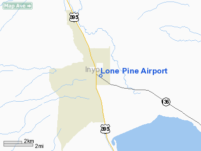
| Lone Pine Airport |
| IATA: none – ICAO: none – FAA LID: O26 |
| Summary |
| Airport type |
Public |
| Location |
Lone Pine, California |
| Elevation AMSL |
3,680 ft / 1,122 m |
| Coordinates |
36°35′17.760″N 118°03′07.313″W / 36.5882667°N 118.05203139°W / 36.5882667; -118.05203139Coordinates: 36°35′17.760″N 118°03′07.313″W / 36.5882667°N 118.05203139°W / 36.5882667; -118.05203139 |
| Runways |
| Direction |
Length |
Surface |
| ft |
m |
| 16/34 |
4,000 |
1,219 |
Asphalt |
| 13G/31G |
2,400 |
732 |
Dirt |
Lone Pine Airport (FAA LID: O26) is a public airport located one mile (1.6 km) southeast of Lone Pine (Geographic coordinates N36-35.30; W118-03.12) serving Inyo County, California, USA. The airport has two runways and is mostly used for general aviation. Charts: San Francisc; L5.
UNICOM/CTAF Frequency: 122.8
Facilities
Lone Pine Airport has two runways:
- Runway 16/34: 4,000 x 60 ft (1,219 x 18 m). Surface: Asphalt
- Runway 13/31: 2,400 x 100 ft (732 x 30 m). Surface: Dirt
The above content comes from Wikipedia and is published under free licenses – click here to read more.
Location
& QuickFacts
|
FAA
Information Effective: |
2006-09-28 |
|
Airport
Identifier: |
O26 |
|
Longitude/Latitude: |
118-03-07.3130W/36-35-17.7600N
-118.052031/36.588267 (Estimated) |
|
Elevation: |
3680 ft / 1121.66 m (Surveyed) |
|
Land: |
79 acres |
|
From
nearest city: |
1 nautical miles SE of Lone Pine, CA |
|
Location: |
Inyo County, CA |
|
Magnetic Variation: |
15E (1985) |
Owner
& Manager
|
Ownership: |
Publicly owned |
|
Owner: |
City Of Los Angeles
LEASED & MAINTAINED BY INYO COUNTY. |
|
Address: |
|
|
Manager: |
Steven Ivey |
|
Address: |
Po Drawer Q
Independence, CA 93526 |
|
Phone number: |
760-878-0201
COUNTY COURTHOUSE INDEPENDENCE. |
Airport
Operations and Facilities
|
Airport
Use: |
Open to public |
|
Wind
indicator: |
Yes |
|
Segmented
Circle: |
Yes |
|
Control
Tower: |
No |
|
Attendance
Schedule: |
IREG |
|
Lighting
Schedule: |
RDO-CTL
ACTVT MIRL RY 16/34 & BCN - CTAF. |
|
Beacon
Color: |
Clear-Green (lighted land airport)
ARPT BCN OTS INDEFLY. |
|
Landing
fee charge: |
No |
|
Sectional
chart: |
San Francisco |
|
Region: |
AWP - Western-Pacific |
|
Traffic
Pattern Alt: |
800 ft |
|
Boundary
ARTCC: |
ZLA - Los Angeles |
|
Tie-in
FSS: |
RAL - Riverside |
|
FSS
on Airport: |
No |
|
FSS
Phone: |
951-351-3020 |
|
FSS
Toll Free: |
1-800-WX-BRIEF |
|
NOTAMs
Facility: |
RAL (NOTAM-d service avaliable) |
|
Federal Agreements: |
NGY |
Airport
Communications
|
CTAF: |
122.800 |
|
Unicom: |
122.800 |
Airport
Services
|
Fuel
available: |
100LLA
FUEL 100LL AVBL 24 HRS BY CREDIT CARD. |
|
Runway
Information
Runway 13G/31G
|
Dimension: |
2400 x 100 ft / 731.5 x 30.5 m |
|
Surface: |
DIRT, Fair Condition |
|
|
Runway 13G |
Runway 31G |
|
Traffic
Pattern: |
Right |
Left |
|
Displaced
threshold: |
625.00 ft |
0.00
ft |
|
Obstruction: |
40 ft trees
APCH RATIO 15:1 TO DSPLCD THLD. |
3 ft fence, 100.0 ft from runway, 50 ft left
of centerline, 33:1 slope to clear |
|
Runway 16/34
|
Dimension: |
4000 x 60 ft / 1219.2 x 18.3 m |
|
Surface: |
ASPH, Good Condition |
|
Weight
Limit: |
Single wheel: 8000 lbs. |
|
Edge
Lights: |
Medium |
|
|
Runway 16 |
Runway 34 |
|
Traffic
Pattern: |
Left |
Right |
|
Markings: |
Basic, Fair Condition |
Basic, Fair Condition |
|
Runway
End Identifier: |
No |
No |
|
Centerline
Lights: |
No |
No |
|
Touchdown
Lights: |
No |
No |
|
Obstruction: |
40 ft tree, 1000.0 ft from runway, 100 ft right
of centerline, 20:1 slope to clear |
4 ft fence, 315.0 ft from runway, 28:1 slope
to clear |
|
Helipad H1
|
Dimension: |
30
x 30 ft / 9.1 x 9.1 m |
|
Surface: |
ASPH, Fair Condition |
|
|
Runway H1 |
Runway |
|
Traffic
Pattern: |
Left |
Left |
|
Radio Navigation
Aids
|
ID |
Type |
Name |
Ch |
Freq |
Var |
Dist |
|
BIH |
VOR/DME |
Bishop |
033X |
109.60 |
15E |
49.8 nm |
Remarks
- HANG
GLIDER ACTIVITY INVOF ARPT.
- RY
13G/31G RSTRD TO GLIDERS ONLY EXCEPT PPR - CTAF.
- HELICOPTER
TFC APCH ARPT FM EAST ALONG TWY TO HELIPAD.
- PILOTS
BE ALERT TO PSBL WIND SHEAR OVER TREES WHILE ON APCH RY 16 WITH SE WINDS
15 KTS OR GTR.
- ESTABD
PRIOR 5/15/59.
Based Aircraft
|
Aircraft
based on field: |
14 |
|
Single
Engine Airplanes: |
14 |
Operational Statistics
|
Aircraft
Operations: |
166/Week |
|
General
Aviation Local: |
64.0% |
|
General
Aviation Itinerant: |
34.9% |
|
Military: |
1.2% |
Lone Pine Airport
Address:
Inyo County, CA
Tel:
760-878-0201
Images
and information placed above are from
http://www.airport-data.com/airport/O26/
We
thank them for the data!
| General
Info |
| Country |
United
States |
| State |
CALIFORNIA
|
| FAA ID |
O26
|
| Latitude |
36-35-17.760N
|
| Longitude |
118-03-07.313W
|
| Elevation |
3680 feet
|
| Near City |
LONE PINE
|
We don't guarantee the information is fresh and accurate. The data may
be wrong or outdated.
For more up-to-date information please refer to other sources.
|
|


