 |
|
| Lee Vining Airport |
| IATA: none – ICAO: none – FAA LID: O24 |
| Summary |
| Airport type |
Public |
| Owner |
City of Los Angeles |
| Operator |
Mono County Assistant
Director of Public Works |
| Location |
Lee Vining, California |
| Elevation AMSL |
6,802 ft / 2,073 m |
| Coordinates |
37°57′28″N 119°06′21″W / 37.95778°N 119.10583°W / 37.95778; -119.10583 |
| Runways |
| Direction |
Length |
Surface |
| ft |
m |
| 15/33 |
4,090 |
1,247 |
Asphalt |
| Statistics (2008) |
| Aircraft operations |
2,000 |
| Source: Federal Aviation Administration |
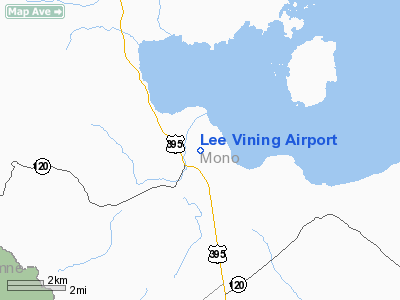
Lee Vining Airport (FAA LID: O24) is a public use airport located one nautical mile (1.8 km) east of the central business district of Lee Vining, a town in Mono County, California, United States. The airport is owned by the City of Los Angeles. It is 0.9 miles (1.4 km) west of Mono Lake, one of the popular destinations in the Mammoth Lakes (Inyo National Forest). Facilities and aircraft
Lee Vining Airport covers an area of 54 acres (22 ha) at an elevation of 6,802 feet (2,073 m) above mean sea level. It has one asphalt paved runway which measures 4,090 by 50 feet (1,247 x 15 m). The runway is 3,760 feet (1,150 m) long between displaced thresholds. The apron measures 295 by 90 feet (90 x 27 m) and can usually accommodate six GA fixed-wing aircraft, near south end of the landing facility.
For the 12-month period ending October 6, 2008, the airport had 2,000 aircraft operations, an average of 166 per month, all of which were general aviation.
The above content comes from Wikipedia and is published under free licenses – click here to read more.
Location
& QuickFacts
|
FAA
Information Effective: |
2006-09-28 |
|
Airport
Identifier: |
O24 |
|
Longitude/Latitude: |
119-06-23.5350W/37-57-29.7310N
-119.106537/37.958259 (Estimated) |
|
Elevation: |
6802 ft / 2073.25 m (Estimated) |
|
Land: |
54 acres |
|
From
nearest city: |
1 nautical miles E of Lee Vining, CA |
|
Location: |
Mono County, CA |
|
Magnetic Variation: |
15E (1985) |
Owner
& Manager
|
Ownership: |
Publicly owned |
|
Owner: |
City Of Los Angeles
LEASED, CONSTRUCTED & MAINTD BY MONO COUNTY. |
|
Address: |
|
|
Phone
number: |
760-873-6361 |
|
Manager: |
Kelly Garcia
MONO COUNTY ASSISTANT DIRECTOR OF PUBLIC WORKS. |
|
Address: |
Po Box 457
Bridgeport, CA 93517 |
|
Phone number: |
760-932-5446 |
Airport
Operations and Facilities
|
Airport
Use: |
Open to public |
|
Wind
indicator: |
Yes |
|
Segmented
Circle: |
No |
|
Control
Tower: |
No |
|
Attendance
Schedule: |
UNATNDD |
|
Lighting
Schedule: |
DUSK-DAWN
ACTVT LIRL RY 15/33 - CTAF. |
|
Beacon
Color: |
Clear-Green (lighted land airport) |
|
Landing
fee charge: |
No |
|
Sectional
chart: |
San Francisco |
|
Region: |
AWP - Western-Pacific |
|
Traffic
Pattern Alt: |
800 ft |
|
Boundary
ARTCC: |
ZOA - Oakland |
|
Tie-in
FSS: |
RAL - Riverside |
|
FSS
on Airport: |
No |
|
FSS
Phone: |
951-351-3020 |
|
FSS
Toll Free: |
1-800-WX-BRIEF |
|
NOTAMs
Facility: |
RAL (NOTAM-d service avaliable) |
|
Federal Agreements: |
NGY |
Airport
Communications
Airport
Services
|
Airframe
Repair: |
NONE |
|
Power
Plant Repair: |
NONE |
|
Bottled
Oxygen: |
NONE |
|
Bulk
Oxygen: |
NONE |
|
Runway Information
Runway 15/33
|
Dimension: |
4090 x 50 ft / 1246.6 x 15.2 m |
|
Surface: |
ASPH, Fair Condition |
|
Weight
Limit: |
Single wheel: 30000 lbs. |
|
Edge
Lights: |
Low |
|
|
Runway 15 |
Runway 33 |
|
Elevation: |
6758.00 ft |
6802.00 ft |
|
Traffic
Pattern: |
Left |
Right |
|
Markings: |
Basic, Fair Condition |
Basic, Fair Condition |
|
Displaced
threshold: |
100.00 ft |
200.00 ft |
|
Runway
End Identifier: |
No |
No |
|
Centerline
Lights: |
No |
No |
|
Touchdown
Lights: |
No |
No |
|
Radio Navigation
Aids
|
ID |
Type |
Name |
Ch |
Freq |
Var |
Dist |
|
BIH |
VOR/DME |
Bishop |
033X |
109.60 |
15E |
49.6 nm |
Operational Statistics
|
Aircraft
Operations: |
39/Week |
|
General
Aviation Itinerant: |
100.0% |
Lee Vining Airport
Address:
Mono County, CA
Tel:
760-873-6361,
760-932-5446
Images
and information placed above are from
http://www.airport-data.com/airport/O24/
We
thank them for the data!
| General
Info |
| Country |
United
States |
| State |
CALIFORNIA
|
| FAA ID |
O24
|
| Latitude |
37-57-29.731N
|
| Longitude |
119-06-23.535W
|
| Elevation |
6802 feet
|
| Near City |
LEE VINING
|
We don't guarantee the information is fresh and accurate. The data may
be wrong or outdated.
For more up-to-date information please refer to other sources.
|
|

