|
|
| Lake Tahoe Airport |
 |
| IATA: TVL – ICAO: KTVL – FAA LID: TVL |
| Summary |
| Airport type |
Public |
| Operator |
The City of South Lake Tahoe |
| Location |
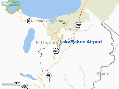
South Lake Tahoe, California |
| Elevation AMSL |
6,264 ft / 1,909.3 m |
| Coordinates |
38°53′38″N 119°59′43″W / 38.89389°N 119.99528°W / 38.89389; -119.99528Coordinates: 38°53′38″N 119°59′43″W / 38.89389°N 119.99528°W / 38.89389; -119.99528 |
| Runways |
| Direction |
Length |
Surface |
| ft |
m |
| 18/36 |
8,544 |
2,604 |
Asphalt |
Lake Tahoe Airport (IATA: TVL, ICAO: KTVL, FAA LID: TVL) is a public airport located three miles (3.8 km) southwest of South Lake Tahoe, serving El Dorado County, California, USA. This general aviation airport covers 348 acres (141 ha) and has one runway. The airport is sometimes called Tahoe Valley Airport. The airport formerly offered commercial to several destinations by various carriers from the late 70s to the early 2000s. For the first few years of airline service, the airport had a ban on pure-jet traffic. As a result, Pacific Southwest Airlines and Air California(later AirCal) delayed the retirement of their Lockheed L-188 Electra to continue service to the airport. PSA ended up retiring their Electras and ending service to Lake Tahoe in 1979 before the ban was lifted. Air California, however, remained at the airport and eventually began pure-jet service with Boeing 737s and MD-80s which served the airport until the airline was acquired by American Airlines in 1987. American continued service briefly with former-AirCal Boeing 737s, but soon gave all Lake Tahoe service to its regional partner American Eagle who continued to serve the airport with Saab 340s and Fairchild Swearingen Metroliners into the 90s. In 1999, Casino Express Airlines started a Tahoe-based carrier under the name of Tahoe Air. The carrier flew Boeing 737-200s serving San Jose(CA) and Los Angeles offering low fares. Around the same time, Allegiant Air, then based in Fresno, began service to Tahoe from Fresno and Las Vegas with DC-9s. The airport was unable to house two large carriers, and Tahoe Air was chosen to stay while Allegiant ended service. Tahoe Air ceased operations that same year, and Lake Tahoe has yet to see airline service since. The Tahoe area is currently served by the nearby Reno-Tahoe International Airport.
Previous Service
| Airlines |
Destinations |
| AirCal |
Los Angeles, San Francisco, San Jose |
| Allegiant Air |
Fresno, Las Vegas |
| American Airlines |
San Jose |
| American Eagle operated by Wings West Airlines |
Los Angeles, San Francisco, San Jose |
| Aspen Airways |
Los Angeles, San Francisco, San Jose |
| Cal Sierra Airlines |
San Diego |
| Golden Gate Airlines |
Reno, San Francisco |
| Golden West Airlines |
Los Angeles, San Diego, Santa Ana |
| Great Sierra Airline |
Oakland, San Jose |
| Hawthorne Nevada Airlines |
Hawthorne(NV) |
| Pacific Coast Airlines |
San Francisco, San Jose |
| Reno Air |
Los Angeles |
| Pacific Southwest Airlines |
Los Angeles |
| Tahoe Air |
Los Angeles, San Jose |
| Yosemite Airlines |
San Francisco |
The above content comes from Wikipedia and is published under free licenses – click here to read more.
Location
& QuickFacts
|
FAA
Information Effective: |
2006-09-28 |
|
Airport
Identifier: |
TVL |
|
Longitude/Latitude: |
119-59-43.2050W/38-53-37.9740N
-119.995335/38.893882 (Estimated) |
|
Elevation: |
6264 ft / 1909.27 m (Surveyed) |
|
Land: |
348 acres |
|
From
nearest city: |
3 nautical miles SW of South Lake Tahoe,
CA |
|
Location: |
El Dorado County, CA |
|
Magnetic Variation: |
16E (1985) |
Owner
& Manager
|
Ownership: |
Publicly owned |
|
Owner: |
South Lake Tahoe |
|
Address: |
1052 Tata Lane
South Lake Tahoe, CA 96150 |
|
Phone
number: |
530-542-6000 |
|
Manager: |
Rick Jenkins |
|
Address: |
1901 Airport Rd Suite 100
South Lake Tahoe, CA 96150 |
|
Phone number: |
530-542-6182 |
Airport
Operations and Facilities
|
Airport
Use: |
Open to public |
|
Wind
indicator: |
Yes |
|
Segmented
Circle: |
Yes |
|
Control
Tower: |
No |
|
Attendance
Schedule: |
ALL/ALL/0630-2000 |
|
Lighting
Schedule: |
DUSK-2000
ACTVT MIRL RY 18-36 MALSF & PAPI RY 18 - CTAF. |
|
Beacon
Color: |
Clear-Green (lighted land airport) |
|
Landing
fee charge: |
No |
|
Sectional
chart: |
San Francisco |
|
Region: |
AWP - Western-Pacific |
|
Traffic
Pattern Alt: |
1000 ft |
|
Boundary
ARTCC: |
ZOA - Oakland |
|
Tie-in
FSS: |
RNO - Reno |
|
FSS
on Airport: |
No |
|
FSS
Phone: |
775-858-1300 |
|
FSS
Toll Free: |
1-800-WX-BRIEF |
|
NOTAMs
Facility: |
TVL (NOTAM-d service avaliable) |
|
Certification
type/date: |
I BS 5/1973
CLSD TO ACR OPNS WITH MORE THAN 30 PSGR SEATS EXCP 24 HRS
PPR CALL AMGR (530) 542-6180. |
|
Federal Agreements: |
NGY |
Airport
Communications
|
CTAF: |
122.950 |
|
Unicom: |
122.950 |
Airport
Services
|
Fuel
available: |
100LLA |
|
Airframe
Repair: |
MINOR |
|
Power
Plant Repair: |
MINOR |
|
Bottled
Oxygen: |
HIGH |
|
Bulk
Oxygen: |
NONE |
|
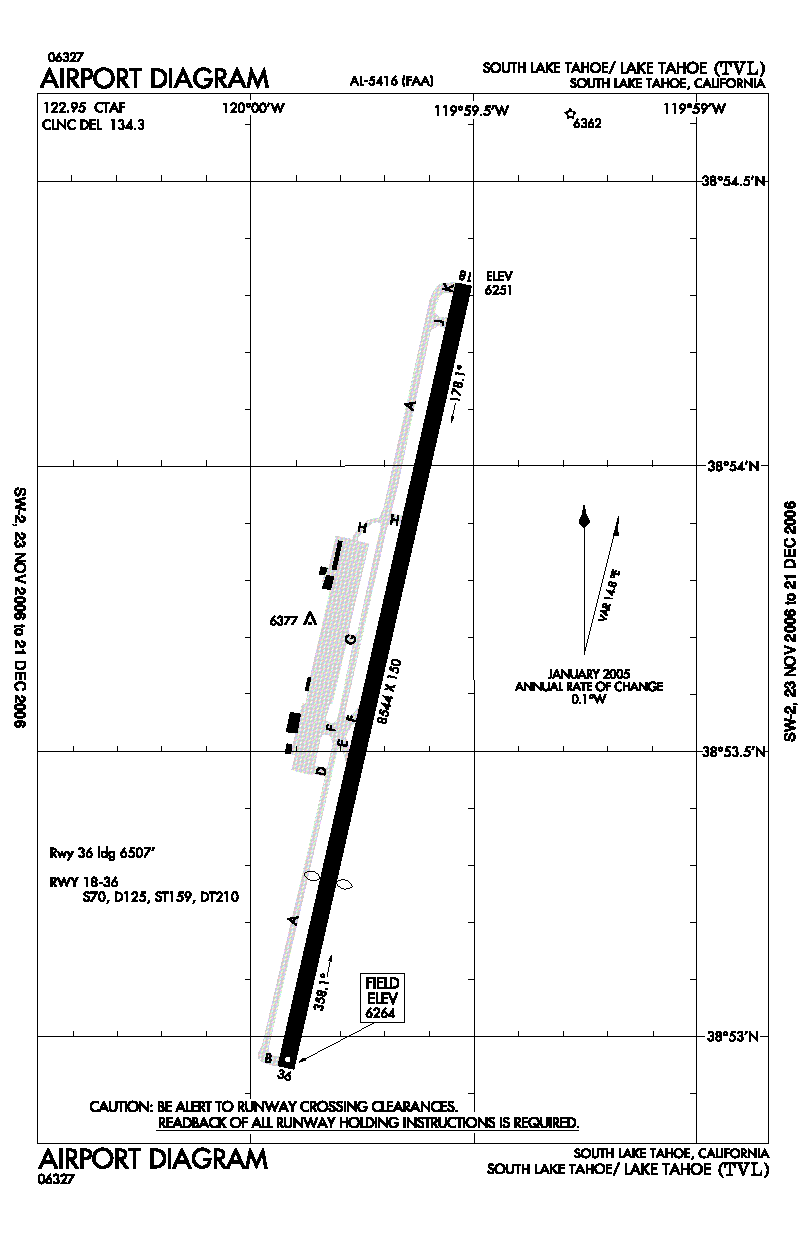
Runway Information
Runway 18/36
|
Dimension: |
8544 x 150 ft / 2604.2 x 45.7 m |
|
Surface: |
ASPH, Good Condition |
|
Surface
Treatment: |
Saw-cut or plastic Grooved |
|
Weight
Limit: |
Single wheel: 70000 lbs.
Dual wheel: 125000 lbs.
Dual
tandem wheel: 210000 lbs. |
|
Edge
Lights: |
Medium |
|
|
Runway 18 |
Runway 36 |
|
Longitude: |
119-59-31.1210W |
119-59-55.2850W |
|
Latitude: |
38-54-19.1180N |
38-52-56.8290N |
|
Elevation: |
6251.00 ft |
6264.00 ft |
|
Alignment: |
127 |
13 |
|
ILS
Type: |
LDA/DME
|
|
|
Traffic
Pattern: |
Left |
Right |
|
Markings: |
Non-precision instrument, Good Condition |
Basic, Good Condition |
|
Crossing
Height: |
47.00 ft |
0.00
ft |
|
Displaced
threshold: |
0.00
ft |
2037.00 ft |
|
VASI: |
4-light PAPI on left side |
|
|
Visual
Glide Angle: |
3.00� |
0.00� |
|
Approach
lights: |
MALSF |
|
|
Runway
End Identifier: |
No |
Yes |
|
Centerline
Lights: |
No |
No |
|
Touchdown
Lights: |
No |
No |
|
Obstruction: |
13 ft bush, 450.0 ft from runway, 125 ft left
of centerline, 19:1 slope to clear |
345 ft trees, 5700.0 ft from runway, 500 ft
right of centerline, 15:1 slope to clear
APCH RATIO 22:1 TO DSPLCD THLD. |
|
Radio Navigation
Aids
|
ID |
Type |
Name |
Ch |
Freq |
Var |
Dist |
|
SWR |
VOR/DME |
Squaw Valley |
079X |
113.20 |
16E |
21.5 nm |
|
HNW |
VOR/DME |
Hangtown |
102X |
115.50 |
17E |
36.8 nm |
|
FMG |
VORTAC |
Mustang |
126X |
117.90 |
16E |
41.4 nm |
Remarks
- ARPT
SFC CONDS: TRML APRON FAIR, TWY - RY 18/36 & GA APRON GOOD.
- AFTER
WINTER STORMS ARPT OPENS BEFORE ALL TWYS ARE CLEAR.
- PREFERRED
ARRIVAL RY 18; PREFERRED DEP RY 36.
- RECREATIONAL
AIRBORNE ACTIVITY ALONG SOUTHERN LAKE SHORE.
- FOR
LARGE AND HIGH PERFORMANCE ACFT DEP RY 18; RIGHT DOWNWIND DEP RECOMMENDED.
- BIRDS
AND WATERFOWL INVOF ARPT.
- ADVERSE
WEATHER EFFECTS MAGNIFIED BY MOUNTAINS.
- TFC
ADVISORIES & SEQUENCING IN THE TFC PAT ARE BASED ON POSITION REPORTS
RECEIVED FROM PILOTS IN THESE AREAS.
- ARPT
SURROUNDED ON E; S & W BY RAPIDLY RISING TERRAIN.
- ACCESS
NOISE RESTRICTIONS: MAX 80 DBA DEP, 84 DBA ARR (TRANSPORT - 86 DBA),
MAX 77.1 DBA NIGHT LIMIT.
- NOISE
ABATEMENT, DEP RY 36, RY HDG 1 MILE, LEFT 320 DEG AT ORANGE ARROW TO
SHORELINE.
- FOR
NOISE ABATEMENT INFORMATION CALL (530) 541-0480 OR WWW.LAKETAHOEAIRPORT.COM.
- AVOID
DESOLATION WILDERNESS WEST OF ARPT.
- ARFF
NOT AVAILABLE WITHOUT PPR, CALL 530-542-6180
- AIRPORT
CLOSED AT NIGHT.
- TPA
7500' MSL FOR SMALL ACFT; 8000' MSL FOR TRANSPORT/HIGH PERFORMANCE ACFT.
- TWY
H WEST OF TWY A RESTRICTED TO ACFT LESS THAN 12500 LBS.
Based Aircraft
|
Aircraft
based on field: |
69 |
|
Single
Engine Airplanes: |
62 |
|
Multi
Engine Airplanes: |
6 |
|
Jet Engine
Airplanes: |
1 |
Operational Statistics
|
Aircraft
Operations: |
68/Day |
|
Air Carrier: |
0.3% |
|
Air Taxi: |
9.4% |
|
General
Aviation Local: |
17.7% |
|
General
Aviation Itinerant: |
69.8% |
|
Military: |
2.4% |
Lake Tahoe Airport
Address:
El Dorado County, CA
Tel:
530-542-6000,
530-542-6182
Images
and information placed above are from
http://www.airport-data.com/airport/TVL/
We
thank them for the data!
| General
Info |
| Country |
United
States |
| State |
CALIFORNIA
|
| FAA ID |
TVL
|
| Latitude |
38-53-37.974N
|
| Longitude |
119-59-43.205W
|
| Elevation |
6264 feet
|
| Near City |
SOUTH
LAKE TAHOE |
We don't guarantee the information is fresh and accurate. The data may
be wrong or outdated.
For more up-to-date information please refer to other sources.
|
|