 |
|
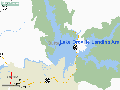
Lake Oroville Landing Area Seaplane Base |
|
|
Location
& QuickFacts
|
FAA
Information Effective: |
2006-09-28 |
|
Airport
Identifier: |
O06 |
|
Longitude/Latitude: |
121-28-03.8850W/39-33-59.5900N
-121.467746/39.566553 (Estimated) |
|
Elevation: |
900 ft / 274.32 m (Estimated)
LAKE ELEVATION VARIES FM 700 - 900 FT MSL. |
|
Land: |
8000 acres |
|
From
nearest city: |
5 nautical miles NE of Oroville, CA |
|
Location: |
Butte County, CA |
|
Magnetic Variation: |
17E (1985) |
Owner
& Manager
|
Ownership: |
Publicly owned |
|
Owner: |
Calif Dept Of Water Resources |
|
Address: |
400 Glen Drive
Oroville, CA 95966 |
|
Phone
number: |
530-538-2200 |
|
Manager: |
Dave Bartlett
SUPERVISOR DEPT OF WATER RESOURCES. |
|
Address: |
400 Glen Drive
Oroville, CA 95966 |
|
Phone number: |
916-538-2200 |
Airport
Operations and Facilities
|
Airport
Use: |
Open to public |
|
Wind
indicator: |
No |
|
Segmented
Circle: |
No |
|
Control
Tower: |
No |
|
Attendance
Schedule: |
UNATNDD |
|
Landing
fee charge: |
No |
|
Sectional
chart: |
San Francisco |
|
Region: |
AWP - Western-Pacific |
|
Traffic
Pattern Alt: |
800 ft |
|
Boundary
ARTCC: |
ZOA - Oakland |
|
Tie-in
FSS: |
RIU - Rancho Murieta |
|
FSS
on Airport: |
No |
|
FSS
Phone: |
916-354-0161 |
|
FSS
Toll Free: |
1-800-WX-BRIEF |
|
NOTAMs
Facility: |
RIU (NOTAM-d service avaliable) |
Airport
Communications
Airport
Services
|
Runway
Information
Runway ALL/WAY
|
Dimension: |
9000 x 9000 ft / 2743.2 x 2743.2 m |
|
Surface: |
WATER, |
|
|
Runway ALL |
Runway WAY |
|
Traffic
Pattern: |
Left |
Left |
|
Radio Navigation
Aids
|
ID |
Type |
Name |
Ch |
Freq |
Var |
Dist |
|
OVE |
NDB |
Oroville |
|
212.00 |
16E |
8.4 nm |
|
MY |
NDB |
Halow |
|
222.00 |
16E |
24.8 nm |
|
PBT |
NDB |
Proberta |
|
338.00 |
16E |
48.4 nm |
|
BAB |
TACAN |
Beale |
023X |
|
16E |
26.0 nm |
|
CIC |
VOR/DME |
Chico |
035X |
109.80 |
16E |
22.1 nm |
|
MYV |
VOR/DME |
Marysville |
045X |
110.80 |
16E |
28.5 nm |
|
MXW |
VORTAC |
Maxwell |
037X |
110.00 |
18E |
38.1 nm |
|
ILA |
VORTAC |
Williams |
091X |
114.40 |
18E |
39.5 nm |
|
RBL |
VORTAC |
Red Bluff |
104X |
115.70 |
18E |
47.8 nm |
Remarks
- TFC
PAT ALT 800'AGL.
- FOR
LAKE INFORMATION CTC MARINA (530) 589-3152.
- LANDING
AREA LOCATED IN CENTER OF MAIN BODY OF LAKE.
- FLOATING
DEBRIS DURING OCT-JUL.
- VFR
USE ONLY.
Operational Statistics
|
Aircraft
Operations: |
3/Month |
|
General
Aviation Itinerant: |
100.0% |
Lake Oroville Landing Area Seaplane Base
Address:
Butte County, CA
Tel:
530-538-2200
Images
and information placed above are from
http://www.airport-data.com/airport/O06/
We
thank them for the data!
| General
Info |
| Country |
United
States |
| State |
CALIFORNIA
|
| FAA ID |
O06
|
| Latitude |
39-33-59.590N
|
| Longitude |
121-28-03.885W
|
| Elevation |
900 feet
|
| Near City |
OROVILLE
|
We don't guarantee the information is fresh and accurate. The data may
be wrong or outdated.
For more up-to-date information please refer to other sources.
|
|


