|
|
|
 |
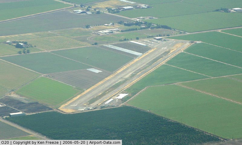
(Click on the photo to enlarge) |
|
 |
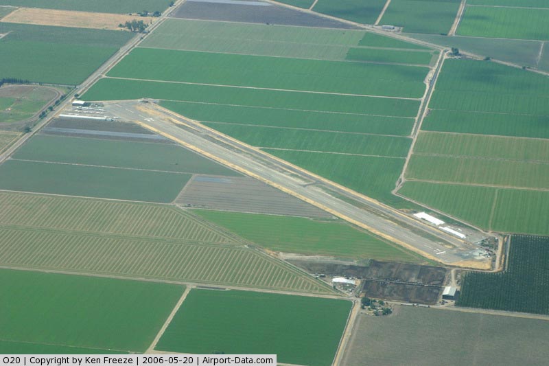
(Click on the photo to enlarge) |
|
 |
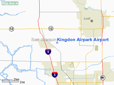
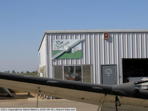
(Click on the photo to enlarge) |
Location
& QuickFacts
|
FAA
Information Effective: |
2006-09-28 |
|
Airport
Identifier: |
O20 |
|
Longitude/Latitude: |
121-21-33.8150W/38-05-29.7110N
-121.359393/38.091586 (Estimated) |
|
Elevation: |
15 ft / 4.57 m (Estimated) |
|
Land: |
41 acres |
|
From
nearest city: |
4 nautical miles SW of Lodi, CA |
|
Location: |
San Joaquin County, CA |
|
Magnetic Variation: |
16E (1985) |
Owner
& Manager
|
Ownership: |
Privately owned |
|
Owner: |
Kingdon Properties |
|
Address: |
9120 Thornton Road Suite 337
Stockton, CA 95209 |
|
Phone
number: |
209-838-7725 |
|
Manager: |
Amrit Grewal |
|
Address: |
9120 Thornton Road, Suite 337
Stockton, CA 95209 |
|
Phone number: |
209-463-7937 |
Airport
Operations and Facilities
|
Airport
Use: |
Open to public |
|
Wind
indicator: |
Yes |
|
Segmented
Circle: |
Yes |
|
Control
Tower: |
No |
|
Attendance
Schedule: |
ALL/MON-FRI/0800-1700 |
|
Lighting
Schedule: |
RDO-CTL
FOR LIRL RWY 12/30 KEY 122.8 5 TIMES. |
|
Landing
fee charge: |
No |
|
Sectional
chart: |
San Francisco |
|
Region: |
AWP - Western-Pacific |
|
Traffic
Pattern Alt: |
800 ft |
|
Boundary
ARTCC: |
ZOA - Oakland |
|
Tie-in
FSS: |
RIU - Rancho Murieta |
|
FSS
on Airport: |
No |
|
FSS
Phone: |
916-354-0161 |
|
FSS
Toll Free: |
1-800-WX-BRIEF |
|
NOTAMs
Facility: |
RIU (NOTAM-d service avaliable) |
Airport
Communications
|
CTAF: |
122.800 |
|
Unicom: |
122.800 |
Airport
Services
|
Fuel
available: |
100LL |
|
Airframe
Repair: |
MAJOR |
|
Power
Plant Repair: |
MAJOR |
|
Bottled
Oxygen: |
NONE |
|
Bulk
Oxygen: |
NONE |
|
Runway Information
Runway 12/30
|
Dimension: |
3705 x 60 ft / 1129.3 x 18.3 m |
|
Surface: |
ASPH, Fair Condition
NW 1000 FT ROUGH SFC. |
|
Edge
Lights: |
Non-standard lighting system
NSTD EDGE LGTS 40 FT FM EDGE OF RY; RY 12 LGTD THR RELOCATED 295
FT; RY 30 LGTD THR RELOCATED 490 FT FOR NIGHT OPNS. 3215 FT OF RY
12/30 USABLE AT NIGHT. |
|
|
Runway 12 |
Runway 30 |
|
Traffic
Pattern: |
Left |
Left |
|
Markings: |
Basic, Good Condition
/30 MARKINGS EXTREMELY FADED; RY 30 DSPLCD THR MKD WITH THR
BAR ONLY; NO NRS; NO CNTRLN. |
Nonstandard, Good Condition |
|
Crossing
Height: |
0.00
ft |
16.00
ft |
|
Displaced
threshold: |
295.00 ft |
490.00 ft |
|
VASI: |
|
tri-color on left side |
|
Visual
Glide Angle: |
0.00� |
4.50� |
|
Runway
End Identifier: |
|
No |
|
Centerline
Lights: |
|
No |
|
Touchdown
Lights: |
|
No |
|
Obstruction: |
3 ft fence, 200.0 ft from runway, 5 ft left
of centerline
APCH RATIO 50:1 FROM DSPLCD THR +3 FT FENCE 135 FT LEFT.
3 FT FENCE 0-200 FT FM RY END; +2 FT DIRT PILES 0 FT FM RY
END 50 FT L & 40 FT FM RY END 100 FT R. |
15 ft road, 300.0 ft from runway, 135 ft right
of centerline, 6:1 slope to clear
APCH RATIO TO DSPLCD THR 50:1; APCH RATIO TO DSPLCD THR OVER
+7' ACFT 45' FM DSPLCD THR 115' LEFT 6:1.
4' FENCE 0'-200' FM RY END; 12' LGT POLE 40' FM RY END 70'
R; +15' LGT POLE 130' FM RY END 100' R; AUTO PARKING LOT IN
E CORNER OF PRIMARY SURFACE. |
|
Radio Navigation
Aids
|
ID |
Type |
Name |
Ch |
Freq |
Var |
Dist |
|
TCY |
NDB |
Tracy |
|
203.00 |
15E |
24.3 nm |
|
LV |
NDB |
Reiga |
|
374.00 |
16E |
28.5 nm |
|
SUU |
TACAN |
Travis |
113X |
|
17E |
29.2 nm |
|
TZZ |
VOR |
Travis |
|
116.40 |
17E |
26.2 nm |
|
CCR |
VOR/DME |
Concord |
117X |
117.00 |
17E |
32.6 nm |
|
MOD |
VOR/DME |
Modesto |
093X |
114.60 |
17E |
33.8 nm |
|
MCC |
VOR/DME |
Mc Clellan |
029X |
109.20 |
17E |
34.7 nm |
|
HNW |
VOR/DME |
Hangtown |
102X |
115.50 |
17E |
47.7 nm |
|
LIN |
VORTAC |
Linden |
095X |
114.80 |
17E |
16.9 nm |
|
ECA |
VORTAC |
Manteca |
107X |
116.00 |
17E |
17.9 nm |
|
SAC |
VORTAC |
Sacramento |
099X |
115.20 |
17E |
23.0 nm |
|
OAK |
VORTAC |
Oakland |
115X |
116.80 |
17E |
46.5 nm |
|
SGD |
VORTAC |
Scaggs Island |
058X |
112.10 |
17E |
48.2 nm |
|
SAC |
VOT |
Sacramento Executive |
|
111.40 |
|
26.2 nm |
|
SMF |
VOT |
Sacramento Metropolitan |
|
111.40 |
|
37.6 nm |
Remarks
- TWY
CLSD INDEFLY.
- ACFT
PARKED 115' LEFT OF RY 30 CNTRLN SE END OF RY PRIOR TO DSPLCD THR.
- HELICOPTERS
RESTRICTED TO EMERGENCY USE ONLY.
- REMOVAL
OF OBSTNS IN PRIMARY & APCH SFCS; ESTAB THR 495' FROM END RWY 30
& 118' FROM END RWY 12. VFR
OPNS ONLY.
Based Aircraft
|
Aircraft
based on field: |
27 |
|
Single
Engine Airplanes: |
25 |
|
Multi
Engine Airplanes: |
2 |
Operational Statistics
|
Aircraft
Operations: |
295/Week |
|
General
Aviation Local: |
56.5% |
|
General
Aviation Itinerant: |
43.5% |
Kingdon Airpark Airport
Address:
San Joaquin County, CA
Tel:
209-838-7725,
209-463-7937
Images
and information placed above are from
http://www.airport-data.com/airport/O20/
We
thank them for the data!
| General
Info |
| Country |
United
States |
| State |
CALIFORNIA
|
| FAA ID |
O20
|
| Latitude |
38-05-29.711N
|
| Longitude |
121-21-33.815W
|
| Elevation |
15 feet
|
| Near City |
LODI
|
We don't guarantee the information is fresh and accurate. The data may
be wrong or outdated.
For more up-to-date information please refer to other sources.
|
|