 |
|
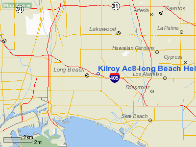
Kilroy Ac8-long Beach Heliport |
|
|
Location
& QuickFacts
|
FAA
Information Effective: |
2006-09-28 |
|
Airport
Identifier: |
CA99 |
|
Longitude/Latitude: |
118-08-46.2420W/33-48-26.0600N
-118.146178/33.807239 (Estimated) |
|
Elevation: |
121 ft / 36.88 m (Estimated) |
|
Land: |
0 acres |
|
From
nearest city: |
3 nautical miles NE of Long Beach, CA |
|
Location: |
Los Angeles County, CA |
|
Magnetic Variation: |
14E (1990) |
Owner
& Manager
|
Ownership: |
Privately owned |
|
Owner: |
Kilroy Industries |
|
Address: |
2250 E. Imperial Hwy
El Segundo, CA 90245 |
|
Phone
number: |
213-772-1193 |
|
Manager: |
Kilroy Long Beach Associates |
|
Address: |
3780 Kilroy Airport Way 530
Long Beach, CA 90806 |
|
Phone number: |
310-988-1160 |
Airport
Operations and Facilities
|
Airport
Use: |
Private |
|
Wind
indicator: |
Yes |
|
Segmented
Circle: |
No |
|
Control
Tower: |
No |
|
Attendance
Schedule: |
UNATNDD |
|
Lighting
Schedule: |
PHONE REQ
FOR PERIMETER LGTS PHONE 310-988-1160 |
|
Sectional
chart: |
Los Angeles |
|
Region: |
AWP - Western-Pacific |
|
Boundary
ARTCC: |
ZLA - Los Angeles |
|
Tie-in
FSS: |
HHR - Hawthorne |
|
FSS
on Airport: |
No |
|
FSS
Phone: |
310-970-0102 |
|
FSS
Toll Free: |
1-800-WX-BRIEF |
|
Runway Information
Helipad H1
|
Dimension: |
50 x 50 ft / 15.2 x 15.2 m |
|
Surface: |
CONC,
ROOFTOP. |
|
|
Runway H1 |
Runway |
|
Traffic
Pattern: |
Left |
Left |
|
Radio Navigation
Aids
|
ID |
Type |
Name |
Ch |
Freq |
Var |
Dist |
|
CPM |
NDB |
Compton |
|
378.00 |
15E |
7.0 nm |
|
EMT |
NDB |
El Monte |
|
359.00 |
15E |
17.8 nm |
|
PAI |
NDB |
Pacoima |
|
370.00 |
15E |
30.3 nm |
|
SB |
NDB |
Petis |
|
397.00 |
14E |
41.7 nm |
|
RIV |
TACAN |
March |
077X |
|
14E |
43.9 nm |
|
NFG |
TACAN |
Camp Pendleton |
055X |
|
13E |
49.7 nm |
|
RAL |
VOR |
Riverside |
|
112.40 |
15E |
35.9 nm |
|
HDF |
VOR |
Homeland |
|
113.40 |
14E |
48.0 nm |
|
SMO |
VOR/DME |
Santa Monica |
045X |
110.80 |
15E |
19.7 nm |
|
ELB |
VOR/DME |
El Toro |
119X |
117.20 |
14E |
22.2 nm |
|
VNY |
VOR/DME |
Van Nuys |
078X |
113.10 |
15E |
30.4 nm |
|
VTU |
VOR/DME |
Ventura |
019X |
108.20 |
15E |
48.7 nm |
|
SLI |
VORTAC |
Seal Beach |
104X |
115.70 |
15E |
4.8 nm |
|
LAX |
VORTAC |
Los Angeles |
083X |
113.60 |
15E |
16.1 nm |
|
POM |
VORTAC |
Pomona |
041X |
110.40 |
15E |
24.2 nm |
|
SXC |
VORTAC |
Santa Catalina |
051X |
111.40 |
15E |
29.4 nm |
|
PDZ |
VORTAC |
Paradise |
059X |
112.20 |
15E |
31.5 nm |
|
FIM |
VORTAC |
Fillmore |
072X |
112.50 |
15E |
49.3 nm |
|
PMD |
VORTAC |
Palmdale |
092X |
114.50 |
15E |
49.7 nm |
|
OCN |
VORTAC |
Oceanside |
100X |
115.30 |
15E |
49.9 nm |
|
LAX |
VOT |
San Pedro Hill |
|
113.90 |
|
10.2 nm |
|
SNA |
VOT |
Santa Ana |
|
110.00 |
|
15.9 nm |
Remarks
- VFR,
PRIVATE USE ONLY; FLIGHT PROCEDURES IN ACCORDANCE WITH LONG BEACH ATCT.
Kilroy Ac8-long Beach Heliport
Address:
Los Angeles County, CA
Tel:
213-772-1193,
310-988-1160
Images
and information placed above are from
http://www.airport-data.com/airport/CA99/
We
thank them for the data!
| General
Info |
| Country |
United
States |
| State |
CALIFORNIA
|
| FAA ID |
CA99
|
| Latitude |
33-48-26.060N
|
| Longitude |
118-08-46.242W
|
| Elevation |
121 feet
|
| Near City |
LONG BEACH
|
We don't guarantee the information is fresh and accurate. The data may
be wrong or outdated.
For more up-to-date information please refer to other sources.
|
|


