|
 |
|
||||
|
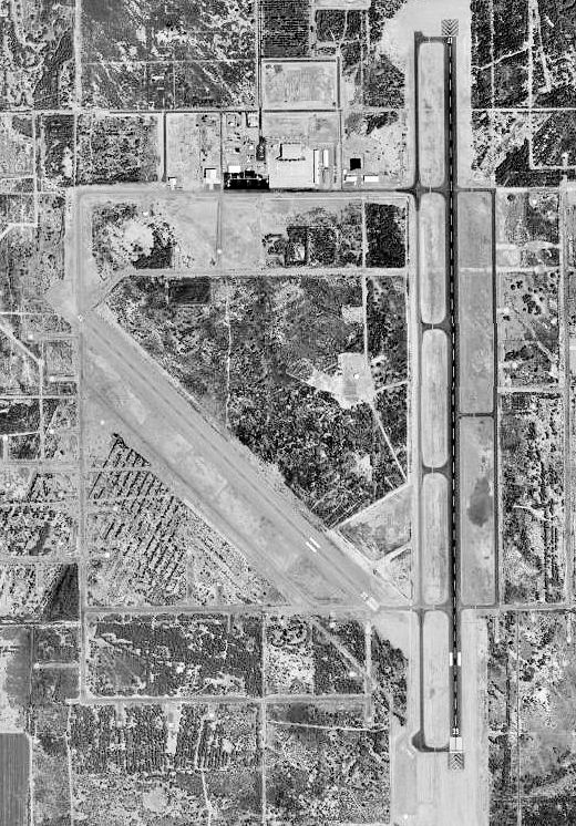
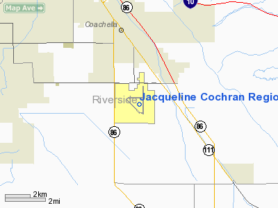
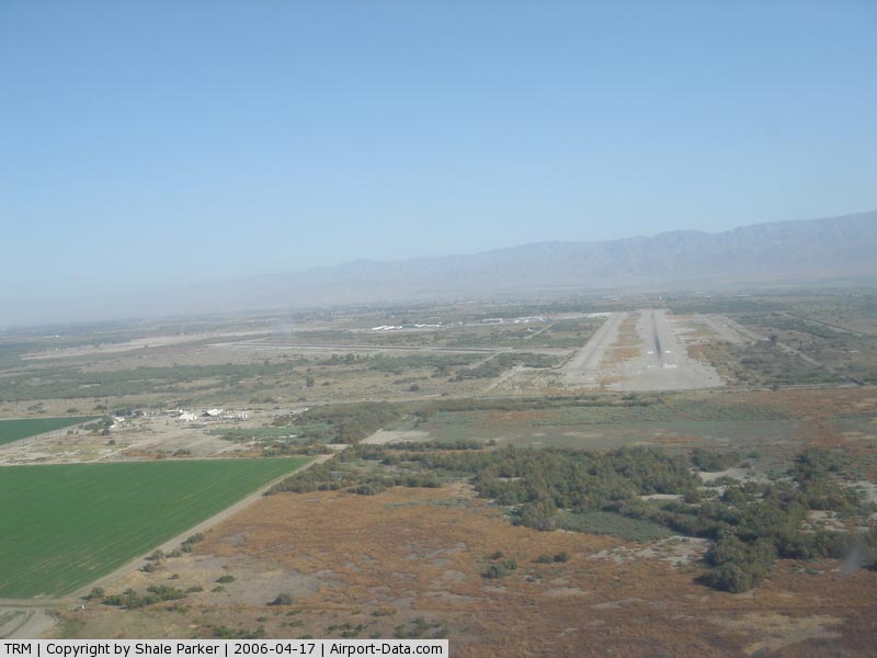
Jacqueline Cochran Regional Airport (IATA: TRM, ICAO: KTRM) is a public airport located in Thermal, California, 20 miles (32 km) southeast of Palm Springs. Built during World War II and used by both the US Army and US Navy, Jacqueline Cochran Regional Airport has had several name changes. As a civilian facility, it was called Thermal Airport from 1948 to 1998. To better reflect its regional function, the name was then changed to Desert Resorts Regional Airport. The most recent name change, to honor the pioneering aviator and Indio resident Jacqueline Cochran, took place in 2004. The airport is one mile (1.6 km) west of the California State Route 86S expressway and six miles (10 km) south of Interstate 10 in the lower Coachella Valley of central Riverside County, an area known as the Desert Resorts Region. The communities of Palm Springs, Palm Desert, Indian Wells, La Quinta, Rancho Mirage, Cathedral City, Coachella, Indio and Thermal surround the airport. The facility hosts an air show in late November, showcasing both full-scale aircraft and radio controlled models as flown by members of the Coachella Valley Radio Control Club. Due to that club's proximity to the facility, both the club and the airport work closely in mid-January to establish no-fly zones for the club's "Best In The West" national jet rally. A temporary model operational ceiling of 2000' (610m) is established during that time due to the size and speed of the models which participate. FacilitiesJacqueline Cochran Regional Airport covers 1,850 acres (7.5 km) and has two runways:
Airport Operational Statistics208 aircraft based at airport.
63 aircraft based at airport.
HistoryThe airport was established in 1942 at the beginning of World War II, being built as part of the Desert Training Center in the Mojave Desert of Southern California. The mission of the training center was to prepare United States Army ground forces in preparation for Operation Torch -- the invasion of North Africa. The center was commanded by General George Patton. The airfield was known as Thermal Ground Support Base or Thermal Army Airfield. The 2,553-acre (10.33 km) facility had two 5,000 ft (1,500 m) runways. Assigned to Fourth Air Force, between March 1943, and May 1944 the Army Air Forces assigned the 76th Reconnaissance Group along with several liaison and tactical reconnaissance squadrons to the airfield. Located in the Coachella Valley 115 feet (35 m) below sea level, the place was named Thermal for a reason. Daily summer temperatures reached 120 °F (49 °C) in the shade soaring much higher on the concrete ramp. Conducting training here was not easy and summer flight operations took place from 0300 to 1300. In the heat of the day, the ground crews simply could not service the aircraft. Phased down in 1944 after most Army units had deployed overseas to combat areas, Thermal had been inactive for six months when the United States Navy requested permission to occupy the base on December 2, 1944 with the stipulation that the Army could reoccupy with 30-days notice. Initially known as Naval Air Bases Detachment Thermal, the base's facilities were in rather poor condition. During the first few months of the Navy's occupancy, the ACORNS and Seabees made extensive improvements. The airfield had a maximum capacity of 2,424 enlisted men and 264 officers. A hospital was located at the facility and had a maximum capacity of 119 patients, 68 nurses, 13 officers, and 16 enlisted men. There were approximately 254 buildings consisting of 237 military buildings built by DoD and 17 non-military buildings (present at the time of base acquisition). The airfield was improved with approximately 250 buildings, heating, lighting, telephone, sewer, water and power systems. NAB Thermal provided pilot refresher training. Aircraft strength reached 115 including the F6F, F4U, TBM, SB2C, and SBD. Station aircraft consisted of a J4F, an N2S, an NE, and a GB. The Navy closed Thermal on November 1, 1945, returning the field to the Army two months later. The facility was inactivated and turned over to the Army Corps of Engineers on 1 January 1946. The War Assets Administration turned the military airfield to civil control during 1947 and 1948. Approximately 39 acres were deeded on 20 June 1947 to United Date Growers of California. Approximately 40 acres were deeded on 2 September 1947 to Coachella Valley County Water District. On 21 December 1948 to the County of Riverside via Quitclaim Deed for use as a municipal airport. Current eraToday, Thermal is a municipal airport serving general aviation. Currently, the site is of approximately 17 parcels totaling 2,549 acres of land owned by both public and private entities. Approximately 2,285 acres are owned by the County of Riverside for use as a municipal airport. The balance is used for agriculture and airpark development. Approximately 188 acres of the property transferred from the DoD to the County of Riverside were subsequently transferred to private parties. The above content comes from Wikipedia and is published under free licenses – click here to read more.
Runway InformationRunway 12/30
Runway 17/35
Radio Navigation Aids
Remarks
Based Aircraft
Operational Statistics
Jacqueline Cochran Regional Airport Address: Riverside County, CA Tel: 951-652-0422 Images
and information placed above are from We thank them for the data!
We don't guarantee the information is fresh and accurate. The data may
be wrong or outdated. |
|||||||||||||||||||||||||||||||||||||||||||||||||||||||||||||||||||||||||||||||||||||||||||||||||||||||||||||||||||||||||||||||||||||||||||||||||||||||||||||||||||||||||||||||||||||||||||||||||||||||||||||||||||||||||||||||||||||||||||||||||||||||||||||||||||||||||||||||||||||||||||||||||||||||||||||||||||||||||||||||||||||||||||||||||||||||||||||||||||||||||||||||||||

 |
|
Copyright 2004-2024 © by Airports-Worldwide.com, Vyshenskoho st. 36, Lviv 79010, Ukraine Legal Disclaimer |