|
|
Jack Northrop Field/hawthorne Municipal Airport |
Hawthorne Municipal Airport
Jack Northrop Field |
 |
| IATA: HHR – ICAO: KHHR |
| Summary |
| Airport type |
Public |
| Operator |
City of Hawthorne |
| Location |
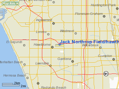
Hawthorne, California |
| Elevation AMSL |
66 ft / 20.1 m |
| Coordinates |
33°55′22″N 118°20′07″W / 33.92278°N 118.33528°W / 33.92278; -118.33528Coordinates: 33°55′22″N 118°20′07″W / 33.92278°N 118.33528°W / 33.92278; -118.33528 |
| Runways |
| Direction |
Length |
Surface |
| ft |
m |
| 7/25 |
4,956 |
1,511 |
Concrete |
Hawthorne Municipal Airport (IATA: HHR, ICAO: KHHR), also known as Jack Northrop Field, is a small public airport located one mile (2 km) east of the central business district (CBD) of Hawthorne, a city in Los Angeles County, California, USA. Airlines
| Airlines |
Destinations |
| Pet Airways |
Broomfield |
Facilities
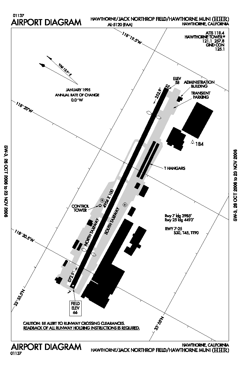
Jack Northrop Field/Hawthorne Municipal Airport covers 80 acres and has one runway:
- Runway 7/25: 4,956 x 100 ft (1,511 x 30 m), Surface: Concrete
History
During World War II the airfield was used by the United States Army Air Force Army Air Forces Training Command.
The above content comes from Wikipedia and is published under free licenses – click here to read more.
Location
& QuickFacts
|
FAA
Information Effective: |
2006-09-28 |
|
Airport
Identifier: |
HHR |
|
Longitude/Latitude: |
118-20-06.6740W/33-55-22.2230N
-118.335187/33.922840 (Estimated) |
|
Elevation: |
66 ft / 20.12 m (Surveyed) |
|
Land: |
80 acres |
|
From
nearest city: |
1 nautical miles E of Hawthorne, CA |
|
Location: |
Los Angeles County, CA |
|
Magnetic Variation: |
14E (1985) |
Owner
& Manager
|
Ownership: |
Publicly owned |
|
Owner: |
City Of Hawthorne |
|
Address: |
City Hall, 4455 W 126 St.
Hawthorne, CA 90250 |
|
Phone
number: |
310-349-2900 |
|
Manager: |
James Theriault |
|
Address: |
12101 S.crenshaw Blvd, Suite # 3
Hawthorne, CA 90250 |
|
Phone number: |
310-970-7215 |
Airport
Operations and Facilities
|
Airport
Use: |
Open to public |
|
Wind
indicator: |
Yes |
|
Segmented
Circle: |
Yes |
|
Control
Tower: |
Yes |
|
Attendance
Schedule: |
ALL/ALL/0700-2000 |
|
Lighting
Schedule: |
DUSK-DAWN
WHEN ATCT CLSD ACTVT MIRL RY 07/25 & ODALS RY 25 - CTAF. |
|
Beacon
Color: |
Clear-Green (lighted land airport) |
|
Landing
fee charge: |
No |
|
Sectional
chart: |
Los Angeles |
|
Region: |
AWP - Western-Pacific |
|
Traffic
Pattern Alt: |
1100 ft |
|
Boundary
ARTCC: |
ZLA - Los Angeles |
|
Tie-in
FSS: |
HHR - Hawthorne |
|
FSS
on Airport: |
Yes |
|
FSS
Phone: |
310-970-0102 |
|
FSS
Toll Free: |
1-800-WX-BRIEF |
|
NOTAMs
Facility: |
HHR (NOTAM-d service avaliable) |
|
Federal Agreements: |
NGSY |
Airport
Communications
Airport
Services
|
Fuel
available: |
100LLA
100LL FUEL AVBL 24 HRS SELF-SERVICE. JET A FUEL AVBL 0500-0000
MON-FRI; 0800-1600 SAT-SUN; CALL (310) 676-4673. |
|
Airframe
Repair: |
MAJOR |
|
Power
Plant Repair: |
MAJOR |
|
Bottled
Oxygen: |
HIGH |
|
Bulk
Oxygen: |
HIGH |
|
Runway Information
Runway 07/25
|
Dimension: |
4956 x 100 ft / 1510.6 x 30.5 m |
|
Surface: |
CONC, Good Condition |
|
Weight
Limit: |
Single wheel: 30000 lbs.
Dual wheel: 45000 lbs.
Dual
tandem wheel: 90000 lbs. |
|
Edge
Lights: |
Medium |
|
|
Runway 07 |
Runway 25 |
|
Longitude: |
118-20-36.0310W |
118-19-37.3180W |
|
Latitude: |
33-55-20.8320N |
33-55-23.6130N |
|
Elevation: |
66.00 ft |
61.00 ft |
|
Alignment: |
87 |
127 |
|
ILS
Type: |
|
LOCALIZER |
|
Traffic
Pattern: |
Right |
Left |
|
Markings: |
Non-precision instrument, Fair Condition |
Non-precision instrument, Fair Condition |
|
Crossing
Height: |
25.00 ft |
25.00 ft |
|
Displaced
threshold: |
971.00 ft |
463.00 ft |
|
VASI: |
2-box on right side |
4-box on right side |
|
Visual
Glide Angle: |
3.25� |
3.50� |
|
Approach
lights: |
|
ODALS |
|
Runway
End Identifier: |
No |
Yes |
|
Centerline
Lights: |
No |
No |
|
Touchdown
Lights: |
No |
No |
|
Obstruction: |
13 ft road, 200.0 ft from runway
APCH RATIO 50:1 TO DSPLCD THR; APCH RATIO TO DSPLCD THR OVER
+12 FT HGR -L 0 FT FROM DSPLCD THR 225 FT LEFT 0:1.
LOC AT RY END. STREET AT 110 FT FROM RY END 07 +37 FT POLE
100 FT FROM E OR 250 FT RIGHT; +10 FT BLDG 100 FT FROM E OR
200 FT RIGHT. |
23 ft pole, 200.0 ft from runway, 100 ft right
of centerline
APCH RATIO 28:1 TO DSPLCD THLD; APCH RATIO TO DSPLCD THLD
OVER +15 FT ROAD 0 FT FM DSPLCD THLD 150 FT RIGHT 0:1.
+8 FT BLAST FENCE LEFT AT 70 FT ON CNTRLN; +23 FT LGT STD
AT 110 FT; STREET AT 110 FT FM RY END 25; 500 FT LEFT &
RIGHT OF CNTRLN; +6 FT FENCE LEFT AT 105 FT FM EOR 500 FT
LEFT & RIGHT OF CNTRLN. |
|
Radio Navigation
Aids
|
ID |
Type |
Name |
Ch |
Freq |
Var |
Dist |
|
CPM |
NDB |
Compton |
|
378.00 |
15E |
4.8 nm |
|
EMT |
NDB |
El Monte |
|
359.00 |
15E |
18.1 nm |
|
PAI |
NDB |
Pacoima |
|
370.00 |
15E |
20.6 nm |
|
SB |
NDB |
Petis |
|
397.00 |
14E |
49.0 nm |
|
GWF |
NDB |
Gen William J Fox |
|
282.00 |
15E |
49.4 nm |
|
NTD |
TACAN |
Point Mugu |
043X |
|
15E |
41.0 nm |
|
RAL |
VOR |
Riverside |
|
112.40 |
15E |
44.2 nm |
|
SMO |
VOR/DME |
Santa Monica |
045X |
110.80 |
15E |
8.0 nm |
|
VNY |
VOR/DME |
Van Nuys |
078X |
113.10 |
15E |
19.7 nm |
|
ELB |
VOR/DME |
El Toro |
119X |
117.20 |
14E |
33.6 nm |
|
VTU |
VOR/DME |
Ventura |
019X |
108.20 |
15E |
37.4 nm |
|
CMA |
VOR/DME |
Camarillo |
105X |
115.80 |
15E |
41.6 nm |
|
LAX |
VORTAC |
Los Angeles |
083X |
113.60 |
15E |
4.9 nm |
|
SLI |
VORTAC |
Seal Beach |
104X |
115.70 |
15E |
16.3 nm |
|
POM |
VORTAC |
Pomona |
041X |
110.40 |
15E |
28.9 nm |
|
SXC |
VORTAC |
Santa Catalina |
051X |
111.40 |
15E |
33.2 nm |
|
FIM |
VORTAC |
Fillmore |
072X |
112.50 |
15E |
37.7 nm |
|
PDZ |
VORTAC |
Paradise |
059X |
112.20 |
15E |
40.2 nm |
|
PMD |
VORTAC |
Palmdale |
092X |
114.50 |
15E |
44.7 nm |
|
LHS |
VORTAC |
Lake Hughes |
021X |
108.40 |
15E |
47.2 nm |
|
LAX |
VOT |
San Pedro Hill |
|
113.90 |
|
10.6 nm |
|
SNA |
VOT |
Santa Ana |
|
110.00 |
|
27.5 nm |
Remarks
- NOISE
SENSITIVE AREAS ALL QUADRANTS. FOR NOISE ABATEMENT INFO CTC AMGR 310-970-7215.
- TGL,
STOP AND GO LDG AND LOW APCH OPNS FOR ALL ACFT INCLUDING HELICOPTERS
LTD TO 1000-1700.
- NO
TAXI-BACK OPNS MON-FRI 2200-0800, SAT-SUN 2200-1000.
- NO
MULTI-ENGINE SIMULATED ENGINE-OUT PROCEDURES AUTHORIZED IN TFC PAT.
- RY
25 RUNUP ON S TWY 900 FT W OF AER.
- NORTH
TWY DESIGNATED NON-MOVEMENT AREA.
- HELICOPTER
FLIGHT TRAINING OPRS PROHIBITED. HELICOPTER MULTIPLE APCHS/TFC PAT OPRS
PROHIBITED.
- FOR
NOISE ABATEMENT INFORMATION CTC AIRPORT DIRECTOR (310) 349-1637.
- CLSD
TO ACFT WITH EXPLOSIVES.
-
< RWY
ON TRML & POLES 07; BLDG-ANT PLINES, HNGRS, 77: PT>
- CTN:
8' BLAST FENCE AER 25.
- NUMEROUS
FLOCKS OF BIRDS ON AND INVOF ARPT.
Based Aircraft
|
Aircraft
based on field: |
163 |
|
Single
Engine Airplanes: |
129 |
|
Multi
Engine Airplanes: |
26 |
|
Jet Engine
Airplanes: |
1 |
|
Helicopters: |
7 |
Operational Statistics
|
Aircraft
Operations: |
220/Day |
|
Air Taxi: |
0.8% |
|
General
Aviation Local: |
46.5% |
|
General
Aviation Itinerant: |
51.6% |
|
Military: |
1.1% |
Jack Northrop Field/hawthorne Municipal
Airport
Address:
Los Angeles County, CA
Tel:
310-349-2900,
310-970-7215
Images
and information placed above are from
http://www.airport-data.com/airport/HHR/
We
thank them for the data!
| General
Info |
| Country |
United
States |
| State |
CALIFORNIA
|
| FAA ID |
HHR
|
| Latitude |
33-55-22.223N
|
| Longitude |
118-20-06.674W
|
| Elevation |
66 feet
|
| Near City |
HAWTHORNE
|
We don't guarantee the information is fresh and accurate. The data may
be wrong or outdated.
For more up-to-date information please refer to other sources.
|
|