 |
|
Coordinates: 30°16′40″N 081°48′21″W / 30.27778°N 81.80583°W / 30.27778; -81.80583
| Herlong Airport |
| IATA: none – ICAO: KHEG – FAA LID: HEG |
| Summary |
| Airport type |
Public |
| Owner |
Jacksonville Aviation Authority |
| Serves |
Jacksonville, Florida |
| Location |
www.jaa.aero/... |
| Elevation AMSL |
87 ft / 27 m |
| Runways |
| Direction |
Length |
Surface |
| ft |
m |
| 7/25 |
4,000 |
1,219 |
Asphalt |
| 11/29 |
3,500 |
1,067 |
Asphalt |
| Statistics (1999) |
| Aircraft operations |
80,700 |
| Based aircraft |
162 |
| Source: Federal Aviation Administration |
Herlong Airport (ICAO: KHEG, FAA LID: HEG) is a public airport located eight miles (13 km) southwest of the central business district of Jacksonville, a city in Duval County, Florida, United States. Although most U.S. airports use the same three-letter location identifier for the FAA and IATA, Herlong Airport is assigned HEG by the FAA but has no designation from the IATA.
The Jacksonville Aviation Authority (JAA) is the owner of all four public airports in Jacksonville and serves as the Fixed Base Operator (FBO) at Herlong. The airport was originally built during World War II to facilitate pilot training for the Navy and Air Force. After the war, the property was given to the city, and subsequently the JAA.
In recognition of the improvements and excellent operations, Herlong Airport was named the Florida Department of Transportation's General Aviation Airport of the Year in 2001.
Facilities and aircraft
Herlong Airport covers an area of 1,484 acres (601 ha) which contains two asphalt paved runways: 7/25 measuring 4,000 x 100 ft (1,219 x 30 m) and 11/29 measuring 3,500 x 100 ft (1,067 x 30 m).
For the 12-month period ending October 20, 1999, the airport had 80,700 aircraft operations, an average of 221 per day: 97% general aviation and 3% military. There are 162 aircraft based at this airport: 70% single-engine, 9% multi-engine, 10% ultralight, 8% glider and 2% helicopter.
The above content comes from Wikipedia and is published under free licenses – click here to read more.
Location
& QuickFacts
|
FAA
Information Effective: |
2006-06-08 |
|
Airport
Identifier: |
H37 |
|
Longitude/Latitude: |
120-10-43.7510W/40-08-19.6490N
-120.178820/40.138791 (Estimated) |
|
Elevation: |
4055 ft / 1235.96 m (Estimated) |
|
Land: |
15 acres |
|
From
nearest city: |
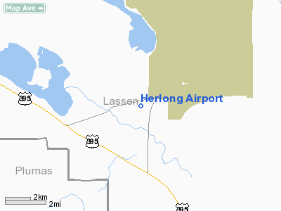
2 nautical miles W of Herlong, CA |
|
Location: |
Lassen County, CA |
|
Magnetic Variation: |
16E (1985) |
Owner
& Manager
|
Ownership: |
Publicly owned |
|
Owner: |
County Of Lassen |
|
Address: |
707 Nevada St
Susanville, CA 96130 |
|
Phone
number: |
916-251-8288 |
|
Manager: |
Tracy Totten
LASSEN COUNTY ASSISTANT DIRECTOR OF PUBLIC WORKS |
|
Address: |
707 Nevada St
Susanville, CA 96130 |
|
Phone
number: |
916-251-8299
LASSEN COUNTY PUBLIC WORKS OFFICE. |
Airport
Operations and Facilities
|
Airport
Use: |
Open to public |
|
Wind
indicator: |
Yes |
|
Segmented
Circle: |
Yes |
|
Control
Tower: |
No |
|
Attendance
Schedule: |
UNATNDD |
|
Landing
fee charge: |
No |
|
Sectional
chart: |
Klamath Falls |
|
Region: |
AWP - Western-Pacific |
|
Traffic
Pattern Alt: |
800 ft |
|
Boundary
ARTCC: |
ZOA - Oakland |
|
Tie-in
FSS: |
RNO - Reno |
|
FSS
on Airport: |
No |
|
FSS
Phone: |
775-858-1300 |
|
FSS
Toll Free: |
1-800-WX-BRIEF |
|
NOTAMs
Facility: |
RNO (NOTAM-d service avaliable) |
Airport
Communications
Airport
Services
|
Airframe
Repair: |
NONE |
|
Power
Plant Repair: |
NONE |
|
Bottled
Oxygen: |
NONE |
|
Bulk
Oxygen: |
NONE |
|
Runway Information
Runway 06/24
|
Dimension: |
3260 x 40 ft / 993.6 x 12.2 m |
|
Surface: |
ASPH, Fair Condition |
|
Weight
Limit: |
Single wheel: 4000 lbs. |
|
|
Runway 06 |
Runway 24 |
|
Traffic
Pattern: |
Left |
Left |
|
Markings: |
Nonstandard, Poor Condition
FADED NUMBERS, NO CENTERLINE, NO THRESHOLD MARKING |
Nonstandard, Poor Condition
FADED NUMBERS, NO CENTERLINE, NO THRESHOLD MARKING |
|
Runway
End Identifier: |
No |
No |
|
Centerline
Lights: |
No |
No |
|
Touchdown
Lights: |
No |
No |
|
Obstruction: |
, 50:1 slope to clear |
30 ft pline, 800.0 ft from runway, 20:1 slope
to clear |
|
Radio Navigation
Aids
|
ID |
Type |
Name |
Ch |
Freq |
Var |
Dist |
|
AHC |
VOR/DME |
Amedee |
027X |
109.00 |
17E |
7.9 nm |
|
FMG |
VORTAC |
Mustang |
126X |
117.90 |
16E |
43.8 nm |
Remarks
- +10
FT BRUSH ALONG NORTHSIDE; 45 FT FROM RY CNTRLN.
Operational Statistics
|
Aircraft
Operations: |
14/Week |
|
General
Aviation Itinerant: |
100.0% |
Herlong Airport
Address:
Lassen County, CA
Tel:
916-251-8288, 916-251-8299
Images
and information placed above are from
http://www.airport-data.com/airport/H37/
We
thank them for the data!
| General
Info |
| Country |
United
States |
| State |
CALIFORNIA
|
| FAA ID |
H37
|
| Latitude |
40.138792
40� 08' 19.65" N |
| Longitude |
-120.178820
120� 10' 43.75" W |
| Elevation |
4055 feet
1236 meters |
| Magnetic
Variation |
015� E
(01/06) |
| Operating
Agency |
U.S.CIVIL
AIRPORT WHEREIN PERMIT COVERS USE BY TRANSIT MILITARY AIRCRAFT
|
| Daylight
Savings Time |
First
Sunday in April at 0200 to last Sunday in October at 0200 local time
(Exception Arizona and that portion of Indiana in the Eastern Time
Zone) |
We don't guarantee the information is fresh and accurate. The data may
be wrong or outdated.
For more up-to-date information please refer to other sources.
|
|


