|
 |
|
||||
|
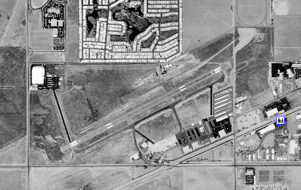
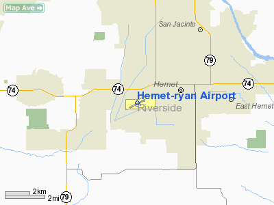
Hemet-Ryan Airport (IATA: HMT, ICAO: KHMT, FAA LID: HMT) is a county-owned, public-use airport located three nautical miles (6 km) southwest of the central business district of Hemet, in Riverside County, California, United States. Hemet-Ryan is a main Cal Fire Air Attack Base, also used for civilian purposes, Civil Air Patrol meetings, and more. It is also home to a Riverside County Sheriff's Department aviation unit and a Mercy Air Air ambulance. The airport is named after the late Claude T. Ryan. HistoryThe airfield was opened in September 1940 by the United States Army Air Corps. It was assigned to the West Coast Training Center (later Western Flying Training Command) as a primary (level 1) pilot training airfield. Later it was activated as a Air Corps Training Detachment with Ryan School of Aeronautics conducting primary flight training under control of 5th Flying Training Detachment. Flight training was performed with PT-17 Stearmans as the primary trainer, along with Ryan PT-21 Recruits. Over 14,000 army cadets were trained to fly. The airport was inactivated in December 1944 with the drawdown of AAFTC's pilot training program, the airfield was declared surplus and turned over to the Army Corps of Engineers. Later, the airfield was discharged to the War Assets Administration. The facility eventually became a public airport owned and operated by Riverside County. Ryan Air Attack
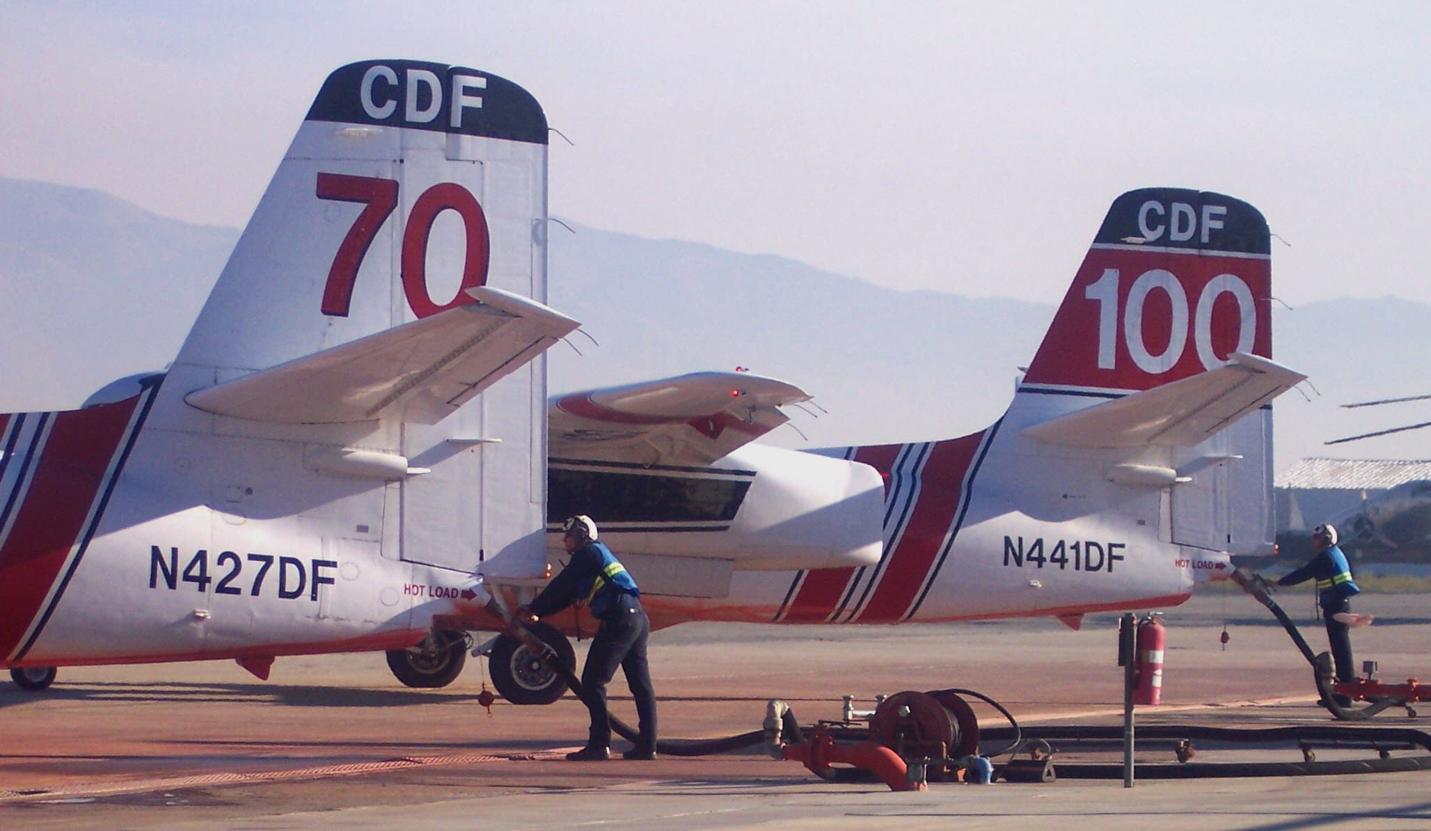
Ryan Air Attack is a joint Air Attack / Helitack base operated by the California Department of Forestry and Fire Protection (Riverside Unit). It is one of 19 tanker bases strategically located throughout California. The base provides initial attack aircraft service to over 17 thousand square miles of private, state, and federally owned lands. Up until 1998, Ryan was statistically the busiest air tanker base in the United States delivering an average of 1.5 million gallons of retardant annually. Currently two S-2 Trackers, an OV-10 and a UH-1H are stationed at the base. The base has served as the primary air attack base for many wildfires, including the Old Fire and Cedar Fire in 2003 and the Esperanza Fire in 2006. History of Ryan Air AttackThe United States Forest Service commenced air tanker loading operations in 1957, and in 1959 California Division of Forestry (now Cal Fire) began their operation at Ryan field. Both agencies maintained separate parking, loading and mixing areas but the initial stages of a joint base operation had begun. In 1969 the United States Forest Service (USFS) and the California Division of Forestry (CDF) truly merged into a joint agency air attack base sharing the base operation, responsibilities and facilities. The joint base concept successfully continued operation until 1998 when the USFS moved their air tanker base operations to the larger and recently vacated Norton Air Force Base. From the beginning of Ryan Air Attack Base, Cal Fire and the USFS used privately owned contracted WWII vintage aircraft. The type and sizes of aircraft varied based on vendor, availability of flyable airframes and spare parts. As the years counted off and the flight hours increased these airplanes became static museum displays or were robbed for parts to keep the dwindling fleet flying. Because of the dwindling air tanker fleet, Cal Fire acquired excess U.S. Navy Grumman S-2A submarine hunting aircraft. These planes were converted from military use to firefighting aircraft using a design developed by Hemet Valley Flying Service. The first two aircraft build-ups were completed by Hemet Valley Flying Service and tested at Ryan Air Attack Base. The basic aircraft design has been in continuous state service since 1975. In 1977 Cal Fire began a two-week pilot helitack program utilizing a contracted helicopter. Headed up by Captain Emil Derdowski and two firefighters, the program was eventually extended to a total of four weeks. The success of this pilot program brought on line the Hemet-Ryan Helitack Base using a full time contract helicopter staffed with three captains and nine firefighters operating out of Ryan Air Attack Base. In 1992 Cal Fire acquired several of the larger Bell UH-1H helicopters with Hemet-Ryan Helitack receiving one of the first buildups. A year later, the OV-10 replaced the older Cessna 337 as Air Attack 310 based at Ryan. In June 2001, Cal Fire replaced the older S-2As at Ryan with Tanker 72 and 73. The new tankers are S-2F3AT Turbine Tanker conversions with upgrades including constant flow 1200 gallon tanks and turbine engines allowing for better capabilities and performance. Future of Ryan Air AttackIn June 2007, The Hemet-Ryan Airport was approved $2.5 million from the Riverside County Board of Supervisors and over $25 million from the state for the redevelopment of the air-attack facilities. The upgrades would include extending the runway from 4,300 feet (1,300 m) to 6,000 feet (1,800 m) to accommodate heavier firefighting aircraft such as the MAFFS C-130. The runway expansion would take place on the south-west portion of the complex and require re-alignment of bordering Stetson Ave. and Warren Road. The new base would also include a 5,842-square-foot (542.7 m), 22-bed barracks building, a 4,812-square-foot (447.0 m) three-bay vehicle storage facility and shop; a 4,646-square-foot (431.6 m), two-story operations building containing pilot facilities, administration and dispatch center; a 15,300-square-foot (1,420 m), two-bay open-shade canopy and an 8,211-square-foot (762.8 m) helicopter/ OV-10 enclosed hangar. Also planned are new public and secured staff parking areas, six fire-retardant loading pits to handle inter-agency aircraft, along with equipment tanks, pumps and piping used to mix and deliver fire retardant. Because of critical need, the strategic location of the base and proven performance and handling of large wildfires, Cal Fire and the state consider the project top priority in the list of firefighting capital improvements.
Facilities and aircraftApart from hosting Cal Fire air attack operations, the Hemet-Ryan is also home to a Riverside County Sheriff's Department aviation unit. In August 2010 the airport became home to an emergency medical helicopter operated by Mercy Air. The airport also hosts a biennial air show with the next one being in 2011. For the 12-month period ending December 31, 2008, the airport had 75,444 general aviation aircraft operations, an average of 206 per day. At that time there were 236 aircraft based at the airport: 48% single-engine, 9% multi-engine, <1% jet, 4% helicopter, 36% glider and 2% ultralight. In 2009, the glider portion of the airport was shutdown to make way for the expansion of Cal Fire facilities. The above content comes from Wikipedia and is published under free licenses – click here to read more.
Runway InformationRunway 04/22
Runway 05/23
Radio Navigation Aids
Remarks
Based Aircraft
Operational Statistics
Hemet-ryan Airport Address: Riverside County, CA Tel: 760-863-2530, 951-600-8591 Images
and information placed above are from We thank them for the data!
We don't guarantee the information is fresh and accurate. The data may
be wrong or outdated. |
||||||||||||||||||||||||||||||||||||||||||||||||||||||||||||||||||||||||||||||||||||||||||||||||||||||||||||||||||||||||||||||||||||||||||||||||||||||||||||||||||||||||||||||||||||||||||||||||||||||||||||||||||||||||||||||||||||||||||||||||||||||||||||||||||||||||||||||||||||||||||||||||||||||||||||||||||||||||||||||||||||||||||||||||||||||||||||||||||||||||||||||||||||||||||||||||||||||||||||||||||||||||||||||||||||||||

 |
|
Copyright 2004-2024 © by Airports-Worldwide.com, Vyshenskoho st. 36, Lviv 79010, Ukraine Legal Disclaimer |