|
|
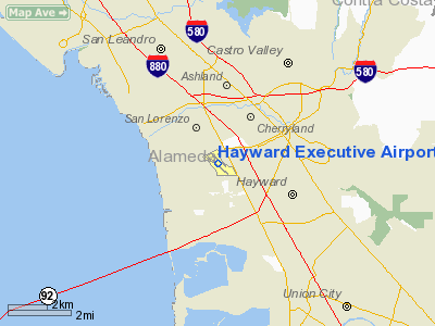
Hayward Executive Airport |
| Hayward Executive Airport |
 |
| IATA: HWD – ICAO: KHWD |
| Summary |
| Airport type |
Public |
| Operator |
City of Hayward |
| Location |
Hayward, California |
| Elevation AMSL |
50 ft / 15.2 m |
| Coordinates |
37°39′33.4″N 122°07′20.7″W / 37.659278°N 122.122417°W / 37.659278; -122.122417Coordinates: 37°39′33.4″N 122°07′20.7″W / 37.659278°N 122.122417°W / 37.659278; -122.122417 |
| Runways |
| Direction |
Length |
Surface |
| ft |
m |
| 10R/28L |
5,024 |
1,531 |
Asphalt |
| 10L/28R |
3,107 |
947 |
Asphalt |
Hayward Executive Airport (IATA: HWD, ICAO: KHWD) is located in Hayward, California, USA, near the eastern shore of San Francisco Bay. History
The airport was built in 1942 during World War II for use as a fighter base as an auxiliary field to Chico Army Air Field and was originally named Hayward Army Airfield. The primary aircraft stationed at the field were Lockheed P-38 Lightning fighter aircraft. This post may have also been named "Russell City Army Air Field" for the unincorporated area outside of the Hayward city limits where it was located. The airfield was assigned to the United States Army Air Forces Fourth Air Force.
After the war ended, the airport was declared surplus property by the federal government.
In April 1947, the War Assets Administration quitclaimed the airfield, comprising some 690 acres (279 ha) and related buildings and equipment, to the City of Hayward. The airfield was then renamed the Hayward Municipal Airport.
The California Air National Guard moved onto land adjoining the airport in 1949. A control tower was erected in 1960. Initially it was the home of the 61st Fighter Wing which included the 194th Fighter Squadron on 25 June 1948.
The 61st Fighter Wing was re-designated as the 144th Fighter Bomber Wing on 1 November 1950. The wing also consisted of the 192nd Fighter Squadron at Reno, Nevada and the 191st Fighter Squadron at Salt Lake City, Utah.
The North American P-51D Mustang and later the P-51H were flown from 1948 until 31 October 1954. During its early years with the P-51D/H, the unit earned prominence as one of the Air Force's most respected aerial gunnery competitors. In June 1953, while still flying the P-51, the unit qualified for the first all-jet, worldwide gunnery meet. Using borrowed F-86A Sabre jets, the 144th, which represented the Air National Guard, placed fifth in competition.
On April 3, 1955 the 129th Air Resupply Squadron was established at Hayward and equipped with Curtiss C-46D Commandos in the Summer 1955 supplemented by Grumman SA-16A Albatrosses in 1958. The C-46Ds were phased out 1 November 1958, and the unit was redesignated as the 129th Troop Carrier Squadron (Medium). On January 20, 1962 the unit reached Group status with federal recognition of the 129th Troop Carrier Group.
On May 1, 1980 the California Air National Guard units at Hayward were reassigned to NAS Moffett Field near San Jose.
Facilities
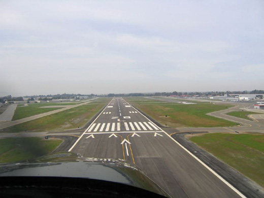 | |
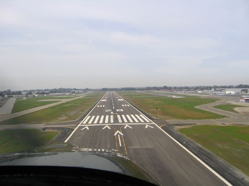
Short-final for runway 28L. |
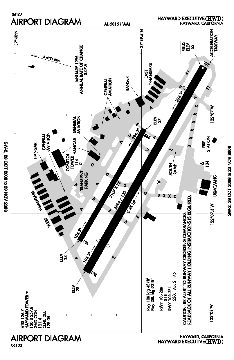
Hayward Executive Airport covers 543 acres (220 ha) and has two runways:
- Runway 10R/28L: 5,024 x 150 ft. (1,531 x 46 m), Surface: Asphalt
- Runway 10L/28R: 3,107 x 75 ft. (947 x 23 m), Surface: Asphalt
The above content comes from Wikipedia and is published under free licenses – click here to read more.
Location
& QuickFacts
|
FAA
Information Effective: |
2006-06-08 |
|
Airport
Identifier: |
HWD |
|
Longitude/Latitude: |
122-07-18.3000W/37-39-32.1000N
-122.121750/37.658917 (Estimated) |
|
Elevation: |
52 ft / 15.85 m (Surveyed) |
|
Land: |
543 acres |
|
From
nearest city: |
2 nautical miles W of Hayward, CA |
|
Location: |
Alameda County, CA |
|
Magnetic Variation: |
16E (1985) |
Owner
& Manager
|
Ownership: |
Publicly owned |
|
Owner: |
City Of Hayward
CITY MANAGER |
|
Address: |
777 B St
Hayward, CA 94541 |
|
Phone number: |
510-583-4310 |
|
Manager: |
Brent Shiner |
|
Address: |
20301 Skywest Dr
Hayward, CA 94541 |
|
Phone number: |
510-293-8678 |
Airport
Operations and Facilities
|
Airport
Use: |
Open to public |
|
Wind
indicator: |
Yes |
|
Segmented
Circle: |
Yes |
|
Control
Tower: |
Yes |
|
Attendance
Schedule: |
ALL/ALL/0800-1700 |
|
Lighting
Schedule: |
DUSK-DAWN
WHEN ATCT CLSD MIRL RY 10R/28L PRESET LOW INTST TO INCREASE
INTST ACTVT - CTAF. WHEN ATCT CLSD VASI RY 10R & RY
28L OPER DUSK-DAWN, PAPI RY 10L & RY 28R AND REIL RY
10R & 28L UNAVBL. |
|
Beacon
Color: |
Clear-Green (lighted land airport) |
|
Landing
fee charge: |
No |
|
Sectional
chart: |
San Francisco |
|
Region: |
AWP - Western-Pacific |
|
Boundary
ARTCC: |
ZOA - Oakland |
|
Tie-in
FSS: |
OAK - Oakland |
|
FSS
on Airport: |
No |
|
FSS
Phone: |
510-273-6111 |
|
FSS
Toll Free: |
1-800-WX-BRIEF |
|
NOTAMs
Facility: |
HWD (NOTAM-d service avaliable) |
|
Federal Agreements: |
NGPRY |
Airport
Communications
|
CTAF: |
120.200 |
|
Unicom: |
122.950 |
Airport
Services
|
Fuel
available: |
100LLA |
|
Airframe
Repair: |
MAJOR |
|
Power
Plant Repair: |
MAJOR |
|
Bottled
Oxygen: |
HIGH |
|
Bulk
Oxygen: |
HIGH |
|
Runway Information
Runway 10L/28R
|
Dimension: |
3107 x 75 ft / 947.0 x 22.9 m |
|
Surface: |
ASPH, Good Condition |
|
Weight
Limit: |
Single wheel: 13000 lbs.
STRENGTH LIMITED BY STRENGTH OF CONNECTING TAXIWAYS. |
|
Edge
Lights: |
Medium |
|
|
Runway 10L |
Runway 28R |
|
Longitude: |
122-07-38.1416W |
122-07-04.6322W |
|
Latitude: |
37-39-44.9116N |
37-39-29.6167N |
|
Elevation: |
28.00 ft |
37.00 ft |
|
Alignment: |
119 |
127 |
|
Traffic
Pattern: |
Left |
Right |
|
Markings: |
Non-precision instrument, |
Non-precision instrument, |
|
VASI: |
4-light PAPI on left side |
4-light PAPI on left side |
|
Visual
Glide Angle: |
3.00� |
3.00� |
|
Runway
End Identifier: |
No |
No |
|
Centerline
Lights: |
No |
No |
|
Touchdown
Lights: |
No |
No |
|
Obstruction: |
40 ft tree, 1000.0 ft from runway, 225 ft left
of centerline, 20:1 slope to clear |
, 50:1 slope to clear |
|
Runway 10R/28L
|
Dimension: |
5694 x 150 ft / 1735.5 x 45.7 m |
|
Surface: |
ASPH, Good Condition |
|
Weight
Limit: |
Single wheel: 30000 lbs.
Dual wheel: 75000 lbs.
STRENGTH LIMITED BY STRENGTH OF CONNECTING TAXIWAYS. |
|
Edge
Lights: |
Medium |
|
|
Runway 10R |
Runway 28L |
|
Longitude: |
122-07-47.2468W |
122-06-45.8415W |
|
Latitude: |
37-39-43.3603N |
37-39-15.3360N |
|
Elevation: |
28.00 ft |
52.00 ft |
|
Alignment: |
119 |
127 |
|
ILS
Type: |
|
LOC/DME |
|
Traffic
Pattern: |
Left |
Left |
|
Markings: |
Precision instrument, Good Condition |
Precision instrument, |
|
Crossing
Height: |
25.00 ft |
35.00 ft |
|
Displaced
threshold: |
816.00 ft |
676.00 ft |
|
VASI: |
4-box on right side |
4-box on left side |
|
Visual
Glide Angle: |
3.00� |
4.00� |
|
Runway
End Identifier: |
Yes |
Yes |
|
Obstruction: |
40 ft tree, 1000.0 ft from runway, 250 ft left
of centerline, 20:1 slope to clear
APCH RATIO 45:1 FM DSPLCD THR. |
, 50:1 slope to clear |
|
Radio Navigation
Aids
|
ID |
Type |
Name |
Ch |
Freq |
Var |
Dist |
|
LV |
NDB |
Reiga |
|
374.00 |
16E |
20.9 nm |
|
TCY |
NDB |
Tracy |
|
203.00 |
15E |
32.3 nm |
|
PDG |
NDB |
Pajar |
|
327.00 |
17E |
47.2 nm |
|
NUQ |
TACAN |
Moffett `111 |
123X |
|
z |
14.0 nm |
|
SUU |
TACAN |
Travis |
113X |
|
17E |
36.2 nm |
|
TZZ |
VOR |
Travis |
|
116.40 |
17E |
43.7 nm |
|
SFO |
VOR/DME |
San Francisco |
105X |
115.80 |
17E |
12.2 nm |
|
SJC |
VOR/DME |
San Jose |
088X |
114.10 |
16E |
19.1 nm |
|
CCR |
VOR/DME |
Concord |
117X |
117.00 |
17E |
23.5 nm |
|
OAK |
VORTAC |
Oakland |
115X |
116.80 |
17E |
6.3 nm |
|
OSI |
VORTAC |
Woodside |
086X |
113.90 |
17E |
17.7 nm |
|
SAU |
VORTAC |
Sausalito |
109X |
116.20 |
17E |
22.4 nm |
|
SGD |
VORTAC |
Scaggs Island |
058X |
112.10 |
17E |
33.5 nm |
|
PYE |
VORTAC |
Point Reyes |
084X |
113.70 |
17E |
43.5 nm |
|
ECA |
VORTAC |
Manteca |
107X |
116.00 |
17E |
46.4 nm |
|
SFO |
VOT |
San Francisco Intl |
|
111.00 |
|
12.3 nm |
Remarks
- CITY
OF HAYWARD FIRE DEPT-3 TRUCK WITH 4-30 & 2-25 LB DRY CHEMICAL, 500
GAL WATER,130 GAL FOAM.
- NOISE
ABATEMENT PROCEDURES ENFORCED CTC ARPT DIRECTOR (510) 293-8678.
- WHEN
ATCT CLSD RWY 10L/28R CLSD.
- RY
10R HAS LANDING DISTANCE REMAINING SIGNS (LGTD) NORTH SIDE OF RY.
- RY
28L HAS LANDING DISTANCE REMAINING SIGNS (LGTD) SOUTH SIDE OF RY.
Based Aircraft
|
Aircraft
based on field: |
496 |
|
Single
Engine Airplanes: |
442 |
|
Multi
Engine Airplanes: |
18
INCLUDES 4 AMPHIBIANS. |
|
Jet Engine
Airplanes: |
17 |
|
Helicopters: |
19 |
Operational Statistics
|
Aircraft
Operations: |
342/Day |
|
Air Taxi: |
1.0% |
|
General
Aviation Local: |
49.7% |
|
General
Aviation Itinerant: |
49.3% |
|
Military: |
0.1% |
Hayward Executive Airport
Address:
Alameda County, CA
Tel:
510-583-4310, 510-293-8678
Images
and information placed above are from
http://www.airport-data.com/airport/HWD/
We
thank them for the data!
| General
Info |
| Country |
United
States |
| State |
CALIFORNIA
|
| FAA ID |
HWD
|
| Latitude |
37-39-33.400N
|
| Longitude |
122-07-20.700W
|
| Elevation |
50 feet
|
| Near City |
HAYWARD
|
We don't guarantee the information is fresh and accurate. The data may
be wrong or outdated.
For more up-to-date information please refer to other sources.
|
|