 |
|
Hanford Municipal Airport |
| Hanford Municipal Airport |
| IATA: none – ICAO: KHJO – FAA LID: HJO |
| Summary |
| Airport type |
Public |
| Owner |
City of Hanford |
| Location |
Hanford, California |
| Elevation AMSL |
244 ft / 74 m |
| Coordinates |
36°19′00″N 119°37′40″W / 36.3166667°N 119.62778°W / 36.3166667; -119.62778 |
| Runways |
| Direction |
Length |
Surface |
| ft |
m |
| 14/32 |
5,175 |
1,577 |
Asphalt |
| Statistics (2007) |
| Aircraft operations |
28,500 |
| Based aircraft |
75 |
| Source: Federal Aviation Administration |
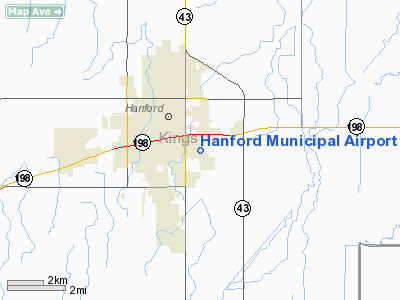
Hanford Municipal Airport (ICAO: KHJO, FAA LID: HJO), formerly O18, is a public airport located one mile (1.6 km) southeast of the central business district of Hanford, a city in Kings County, California, United States. It is owned by the City of Hanford.
Although most U.S. airports use the same three-letter location identifier for the FAA and IATA, Hanford Municipal Airport is assigned HJO by the FAA but has no designation from the IATA.
Facilities and aircraft
Hanford Municipal Airport covers an area of 132 acres (53 ha) which contains one asphalt paved runway (14/32) measuring 5,175 x 75 ft (1,577 x 23 m).
For the 12-month period ending March 29, 2007, the airport had 28,500 aircraft operations, an average of 78 per day, all of which were general aviation. There are 75 aircraft based at this airport: 85% single engine and 15% multi-engine.
The above content comes from Wikipedia and is published under free licenses – click here to read more.
Location
& QuickFacts
|
FAA
Information Effective: |
2006-06-08 |
|
Airport
Identifier: |
HJO |
|
Longitude/Latitude: |
119-37-39.5000W/36-19-00.2000N
-119.627639/36.316722 (Estimated) |
|
Elevation: |
244 ft / 74.37 m (Estimated) |
|
Land: |
132 acres |
|
From
nearest city: |
1 nautical miles SE of Hanford, CA |
|
Location: |
Kings County, CA |
|
Magnetic Variation: |
15E (1985) |
Owner
& Manager
|
Ownership: |
Publicly owned |
|
Owner: |
City Of Hanford |
|
Address: |
315 N Douty St
Hanford, CA 93230 |
|
Phone
number: |
559-585-2520 |
|
Manager: |
Wilmer W Cope |
|
Address: |
315 N Douty St
Hanford, CA 93230 |
|
Phone number: |
559-585-2589 |
Airport
Operations and Facilities
|
Airport
Use: |
Open to public |
|
Wind
indicator: |
Yes |
|
Segmented
Circle: |
Yes |
|
Control
Tower: |
No |
|
Attendance
Schedule: |
ALL/ALL/0800-1700 |
|
Lighting
Schedule: |
DUSK-DAWN
AFTER DARK ACTVT MIRL RY 14/32; PAPI RY 14 & RY 32,
REIL RY 32 - CTAF. |
|
Beacon
Color: |
Clear-Green (lighted land airport) |
|
Landing
fee charge: |
No |
|
Sectional
chart: |
San Francisco |
|
Region: |
AWP - Western-Pacific |
|
Traffic
Pattern Alt: |
1000 ft |
|
Boundary
ARTCC: |
ZOA - Oakland |
|
Tie-in
FSS: |
RIU - Rancho Murieta |
|
FSS
on Airport: |
No |
|
FSS
Phone: |
916-354-0161 |
|
FSS
Toll Free: |
1-800-WX-BRIEF |
|
NOTAMs
Facility: |
HJO (NOTAM-d service avaliable) |
|
Federal Agreements: |
NGY |
Airport
Communications
|
CTAF: |
122.800 |
|
Unicom: |
122.800 |
Airport
Services
|
Fuel
available: |
100LLA
FUEL SELF-SERVICE AVBL 24 HRS. |
|
Airframe
Repair: |
MAJOR |
|
Power
Plant Repair: |
MAJOR |
|
Bottled
Oxygen: |
NONE |
|
Bulk
Oxygen: |
NONE |
|
Runway Information
Runway 14/32
|
Dimension: |
5175 x 75 ft / 1577.3 x 22.9 m |
|
Surface: |
ASPH, Good Condition |
|
Weight
Limit: |
Single wheel: 15000 lbs. |
|
Edge
Lights: |
Medium |
|
|
Runway 14 |
Runway 32 |
|
Longitude: |
119-37-54.6000W |
119-37-24.5000W |
|
Latitude: |
36-19-22.7000N |
36-18-37.7000N |
|
Elevation: |
244.00 ft |
242.00 ft |
|
Alignment: |
127 |
127 |
|
Traffic
Pattern: |
Left |
Right |
|
Markings: |
Basic, Good Condition |
Non-precision instrument, Good Condition |
|
Crossing
Height: |
40.00 ft |
40.00 ft |
|
VASI: |
4-light PAPI on right side
PAPI RY 14 UNUSBL BYD 1 NM. |
4-light PAPI on left side
PAPI RY 32 UNUSBL BYD 2 NM. |
|
Visual
Glide Angle: |
3.50� |
3.00� |
|
Runway
End Identifier: |
No |
Yes |
|
Centerline
Lights: |
No |
No |
|
Touchdown
Lights: |
No |
No |
|
Obstruction: |
17 ft road, 245.0 ft from runway, 2:1 slope
to clear |
, 50:1 slope to clear |
|
Radio Navigation
Aids
|
ID |
Type |
Name |
Ch |
Freq |
Var |
Dist |
|
COR |
NDB |
Salyer Farms |
|
205.00 |
16E |
15.7 nm |
|
CUK |
NDB |
Academy |
|
266.00 |
14E |
24.8 nm |
|
FCH |
NDB |
Chandler |
|
344.00 |
15E |
26.4 nm |
|
NLC |
TACAN |
Lemoore |
080X |
|
16E |
16.5 nm |
|
VIS |
VOR/DME |
Visalia |
031X |
109.40 |
16E |
7.7 nm |
|
TTE |
VOR/DME |
Tule |
029X |
109.20 |
16E |
38.2 nm |
|
CZQ |
VORTAC |
Clovis |
076X |
112.90 |
15E |
35.3 nm |
|
AVE |
VORTAC |
Avenal |
118X |
117.10 |
16E |
43.7 nm |
|
FRA |
VORTAC |
Friant |
103X |
115.60 |
17E |
47.4 nm |
Based Aircraft
|
Aircraft
based on field: |
75 |
|
Single
Engine Airplanes: |
64 |
|
Multi
Engine Airplanes: |
11 |
Operational Statistics
|
Aircraft
Operations: |
79/Day |
|
General
Aviation Local: |
50.0% |
|
General
Aviation Itinerant: |
50.0% |
Hanford Municipal Airport
Address:
Kings County, CA
Tel:
559-585-2520,
559-585-2589
Images
and information placed above are from
http://www.airport-data.com/airport/HJO/
We
thank them for the data!
| General
Info |
| Country |
United
States |
| State |
CALIFORNIA
|
| FAA ID |
HJO
|
| Latitude |
36-19-06.679N
|
| Longitude |
119-37-43.923W
|
| Elevation |
242 feet
|
| Near City |
HANFORD
|
We don't guarantee the information is fresh and accurate. The data may
be wrong or outdated.
For more up-to-date information please refer to other sources.
|
|


