 |
|
| Half Moon Bay Airport |
| IATA: HAF – ICAO: KHAF – FAA LID: HAF |
| Summary |
| Airport type |
Public |
| Owner |
San Mateo County |
| Location |
Moss Beach, near Half Moon Bay, California |
| Elevation AMSL |
66 ft / 20 m |
| Coordinates |
37°30′48″N 122°30′04″W / 37.51333°N 122.50111°W / 37.51333; -122.50111Coordinates: 37°30′48″N 122°30′04″W / 37.51333°N 122.50111°W / 37.51333; -122.50111 |
| Runways |
| Direction |
Length |
Surface |
| ft |
m |
| 12/30 |
5,000 |
1,524 |
Asphalt/Concrete |
| Statistics (2008) |
| Aircraft operations |
60,150 |
| Based aircraft |
40 |
| Source: Federal Aviation Administration |
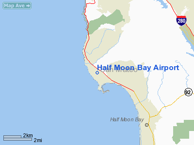
Half Moon Bay Airport (IATA: HAF, ICAO: KHAF, FAA LID: HAF) is a county-owned public use airport in San Mateo County, California, United States. It is located five nautical miles (9 km) northwest of the central business district of Half Moon Bay, California. The airport is on the Pacific Coast, south of San Francisco. History
The Half Moon Bay Airport is located approximately 20 miles south of San Francisco. It was constructed by the California State Highway Department for the U.S. Army in 1942. Known as Half Moon Bay Flight Strip, the Army turned the airport over to the U.S. Navy following the end of World War II and San Mateo County acquired the airport from the Navy in 1947. The airport has served a variety of roles over the years and is currently an important business, transportation and emergency service asset to the community.
Facilities and aircraft
Half Moon Bay Airport covers an area of 325 acres (132 ha) at an elevation of 66 feet (20 m) above mean sea level. It has one runway designated 12/30 with an asphalt/concrete surface measuring 5,000 by 150 feet (1,524 x 46 m).
Half Moon Bay Airport provides a variety of emergency service and response functions including: Air-Ambulance and Medevac flights; law enforcement and homeland security patrols; Coast Guard sea-rescue operations; and use as a disaster relief staging site for the airlifting of emergency supplies in the event that roads are closed during a disaster or emergency.
The Half Moon Bay Airport is home to approximately 80 aircraft and several aviation related businesses. The Airport is self-funded through airport user and business fees and receives no money from the County’s General Fund.
For the 12-month period ending September 11, 2008, the airport had 60,150 aircraft operations, an average of 164 per day: 99.8% general aviation and 0.2% air taxi. At that time there were 40 aircraft based at this airport: 93% single-engine, 5% multi-engine and 3% helicopter.
The above content comes from Wikipedia and is published under free licenses – click here to read more.
Location
& QuickFacts
|
FAA
Information Effective: |
2006-06-08 |
|
Airport
Identifier: |
HAF |
|
Longitude/Latitude: |
122-30-04.2000W/37-30-48.4000N
-122.501167/37.513444 (Estimated) |
|
Elevation: |
66 ft / 20.12 m (Surveyed) |
|
Land: |
325 acres |
|
From
nearest city: |
5 nautical miles NW of Half Moon Bay, CA |
|
Location: |
San Mateo County, CA |
|
Magnetic Variation: |
15E (1995) |
Owner
& Manager
|
Ownership: |
Publicly owned |
|
Owner: |
San Mateo County |
|
Address: |
555 County Center, 5th Floor
Redwood City, CA 94063-1665 |
|
Phone
number: |
650-573-3700
DIRECTOR OF PUBLIC WORKS: NEIL R. CULLEN. |
|
Manager: |
Mark Larson
MANAGER LOCATED AT SAN CARLOS AIRPORT. |
|
Address: |
620 Airport Drive
San Carlos, CA 94070 |
|
Phone number: |
650-573-3700
MANAGERS OFFICE AIRPORT PHONE 650-573-3701. |
Airport
Operations and Facilities
|
Airport
Use: |
Open to public |
|
Wind
indicator: |
Yes |
|
Segmented
Circle: |
Yes |
|
Control
Tower: |
No |
|
Attendance
Schedule: |
ALL/ALL/0800-1700 |
|
Lighting
Schedule: |
DUSK-DAWN
ACTVT MIRL RWY 12/30 & REIL RWY 30 - 122.8. |
|
Beacon
Color: |
Clear-Green (lighted land airport) |
|
Landing
fee charge: |
No |
|
Sectional
chart: |
San Francisco |
|
Region: |
AWP - Western-Pacific |
|
Traffic
Pattern Alt: |
933 ft |
|
Boundary
ARTCC: |
ZOA - Oakland |
|
Tie-in
FSS: |
OAK - Oakland |
|
FSS
on Airport: |
No |
|
FSS
Phone: |
510-273-6111 |
|
FSS
Toll Free: |
1-800-WX-BRIEF |
|
NOTAMs
Facility: |
OAK (NOTAM-d service avaliable) |
|
Federal Agreements: |
NGRY |
Airport
Communications
|
CTAF: |
122.800 |
|
Unicom: |
122.800 |
Airport
Services
|
Fuel
available: |
100LL
FUEL AVBL 24 HRS SELF SERVICE. |
|
Airframe
Repair: |
MAJOR |
|
Power
Plant Repair: |
MAJOR |
|
Bottled
Oxygen: |
NONE |
|
Bulk
Oxygen: |
NONE |
|
Runway Information
Runway 12/30
|
Dimension: |
5000 x 150 ft / 1524.0 x 45.7 m |
|
Surface: |
ASPH-CONC, Good Condition |
|
Weight
Limit: |
Single wheel: 30000 lbs.
Dual wheel: 200000 lbs.
Dual tandem wheel: 360000 lbs.
TWYS, APRONS AND TIEDOWNS 12,500 LBS MAXIMUM. |
|
Edge
Lights: |
Medium |
|
|
Runway 12 |
Runway 30 |
|
Longitude: |
122-30-25.3737W |
122-29-42.9993W |
|
Latitude: |
37-31-06.4216N |
37-30-30.3128N |
|
Elevation: |
66.00 ft |
32.00 ft |
|
Alignment: |
127 |
127 |
|
Traffic
Pattern: |
Left |
Right |
|
Markings: |
Basic, Good Condition |
Basic, Good Condition |
|
Crossing
Height: |
0.00
ft |
26.00 ft |
|
Displaced
threshold: |
763.00 ft |
763.00 ft |
|
VASI: |
|
4-box on left side |
|
Visual
Glide Angle: |
0.00� |
3.00� |
|
Runway
End Identifier: |
No |
Yes |
|
Centerline
Lights: |
No |
No |
|
Touchdown
Lights: |
No |
No |
|
Obstruction: |
70 ft trees, 1600.0 ft from runway, 400 ft
left of centerline, 20:1 slope to clear
APCH RATIO TO DSPLCD THR 50:1. |
40 ft trees, 1900.0 ft from runway, 250 ft
right of centerline, 42:1 slope to clear
APCH RATIO TO DSPLCD THR 50:1. |
|
Radio Navigation
Aids
|
ID |
Type |
Name |
Ch |
Freq |
Var |
Dist |
|
LV |
NDB |
Reiga |
|
374.00 |
16E |
40.4 nm |
|
PDG |
NDB |
Pajar |
|
327.00 |
17E |
49.0 nm |
|
NUQ |
TACAN |
Moffett |
123X |
|
17E |
21.7 nm |
|
SFO |
VOR/DME |
San Francisco |
105X |
115.80 |
17E |
8.8 nm |
|
SJC |
VOR/DME |
San Jose |
088X |
114.10 |
16E |
27.8 nm |
|
CCR |
VOR/DME |
Concord |
117X |
117.00 |
17E |
38.6 nm |
|
OSI |
VORTAC |
Woodside |
086X |
113.90 |
17E |
12.8 nm |
|
OAK |
VORTAC |
Oakland |
115X |
116.80 |
17E |
18.4 nm |
|
SAU |
VORTAC |
Sausalito |
109X |
116.20 |
17E |
20.6 nm |
|
PYE |
VORTAC |
Point Reyes |
084X |
113.70 |
17E |
38.2 nm |
|
SGD |
VORTAC |
Scaggs Island |
058X |
112.10 |
17E |
40.5 nm |
|
SFO |
VOT |
San Francisco Intl |
|
111.00 |
|
8.7 nm |
Remarks
- FLD
CONDS-RWY, TWY & APRON GOOD.
- ARPT
NOISE SENSITIVE AREAS NW THRU NE.
- NO
STRAIGHT-IN APCHS, DEPS CLIMB TO 433 FT AGL BEFORE TURNING.
- NO
INTERSECTION TKOFS, STOP AND GO LANDINGS, OR TAXI-BACK ON RY.
Based Aircraft
|
Aircraft
based on field: |
70 |
|
Single
Engine Airplanes: |
65 |
|
Multi
Engine Airplanes: |
5 |
Operational Statistics
|
Aircraft
Operations: |
165/Day |
|
Air Taxi: |
0.2% |
|
General
Aviation Local: |
41.6% |
|
General
Aviation Itinerant: |
58.2% |
Half Moon Bay Airport
Address:
San Mateo County, CA
Tel:
650-573-3700
Images
and information placed above are from
http://www.airport-data.com/airport/HAF/
We
thank them for the data!
| General
Info |
| Country |
United
States |
| State |
CALIFORNIA
|
| FAA ID |
HAF
|
| Latitude |
37-30-49.786N
|
| Longitude |
122-30-03.921W
|
| Elevation |
67 feet
|
| Near City |
HALF MOON
BAY |
We don't guarantee the information is fresh and accurate. The data may
be wrong or outdated.
For more up-to-date information please refer to other sources.
|
|


