 |
|
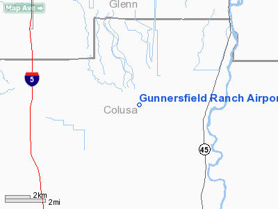
Gunnersfield Ranch Airport |
|
|
Location
& QuickFacts
|
FAA
Information Effective: |
2006-06-08 |
|
Airport
Identifier: |
71CL |
|
Longitude/Latitude: |
122-05-37.9160W/39-21-09.5910N
-122.093866/39.352664 (Estimated) |
|
Elevation: |
62 ft / 18.90 m (Estimated) |
|
Land: |
0 acres |
|
From
nearest city: |
4 nautical miles E of Delevan, CA |
|
Location: |
Colusa County, CA |
|
Magnetic Variation: |
17E (1985) |
Owner
& Manager
|
Ownership: |
Privately owned |
|
Owner: |
Jon B. Chaney |
|
Address: |
Po Box 626
Maxwell, CA 95955 |
|
Phone number: |
916-438-2504 |
|
Manager: |
Douglas Mc Geoghegan |
|
Address: |
Po Box 626
Maxwell, CA 95955 |
|
Phone number: |
916-438-2504 |
Airport
Operations and Facilities
|
Airport
Use: |
Private |
|
Wind
indicator: |
Yes |
|
Segmented
Circle: |
No |
|
Control
Tower: |
No |
|
Attendance
Schedule: |
UNATNDD |
|
Beacon
Color: |
Clear-Green (lighted land airport) |
|
Landing fee charge: |
No |
|
Sectional chart: |
San Francisco |
|
Region: |
AWP - Western-Pacific |
|
Boundary ARTCC: |
ZOA - Oakland |
|
Tie-in FSS: |
RIU - Rancho Murieta |
|
FSS on Airport: |
No |
|
FSS Phone: |
916-354-0161 |
|
FSS Toll Free: |
1-800-WX-BRIEF |
Airport
Communications
|
Unicom: |
122.800
UNICOM OPERATED AS REQUIRED. |
Airport
Services
|
Airframe
Repair: |
NONE |
|
Power
Plant Repair: |
NONE |
|
Runway Information
Runway 16/34
|
Dimension: |
2570 x 40 ft / 783.3 x 12.2 m |
|
Surface: |
ASPH, |
|
Edge
Lights: |
Low |
|
|
Runway 16 |
Runway 34 |
|
Traffic
Pattern: |
Left |
Left |
|
Obstruction: |
|
4 ft levee, 20.0 ft from runway |
|
Radio Navigation
Aids
|
ID |
Type |
Name |
Ch |
Freq |
Var |
Dist |
|
OVE |
NDB |
Oroville |
|
212.00 |
16E |
23.5 nm |
|
MY |
NDB |
Halow |
|
222.00 |
16E |
25.1 nm |
|
LOP |
NDB |
Lampson |
|
217.00 |
16E |
42.6 nm |
|
PBT |
NDB |
Proberta |
|
338.00 |
16E |
46.2 nm |
|
BAB |
TACAN |
Beale |
023X |
|
16E |
33.1 nm |
|
CIC |
VOR/DME |
Chico |
035X |
109.80 |
16E |
28.7 nm |
|
MYV |
VOR/DME |
Marysville |
045X |
110.80 |
16E |
28.7 nm |
|
MXW |
VORTAC |
Maxwell |
037X |
110.00 |
18E |
6.3 nm |
|
ILA |
VORTAC |
Williams |
091X |
114.40 |
18E |
17.2 nm |
|
RBL |
VORTAC |
Red Bluff |
104X |
115.70 |
18E |
45.3 nm |
|
SMF |
VOT |
Sacramento Metropolitan |
|
111.40 |
|
46.2 nm |
Remarks
- LGTD/MKD
HANGER NEAR RWY.
- FIRST
REPORTED 5/25/65-ARPT IS 12 NM SE OF GLENN CO ARPT.
Based Aircraft
|
Aircraft
based on field: |
1 |
|
Single
Engine Airplanes: |
1 |
Gunnersfield Ranch Airport
Address:
Colusa County, CA
Tel:
916-438-2504
Images
and information placed above are from
http://www.airport-data.com/airport/71CL/
We
thank them for the data!
| General
Info |
| Country |
United
States |
| State |
CALIFORNIA
|
| FAA ID |
71CL
|
| Latitude |
39-21-09.591N
|
| Longitude |
122-05-37.916W
|
| Elevation |
62 feet
|
| Near City |
DELEVAN
|
We don't guarantee the information is fresh and accurate. The data may
be wrong or outdated.
For more up-to-date information please refer to other sources.
|
|


