|
|
Fresno Yosemite International Airport |
| Fresno Yosemite International Airport |
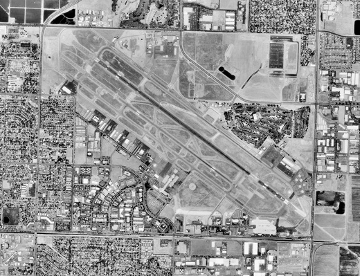 |
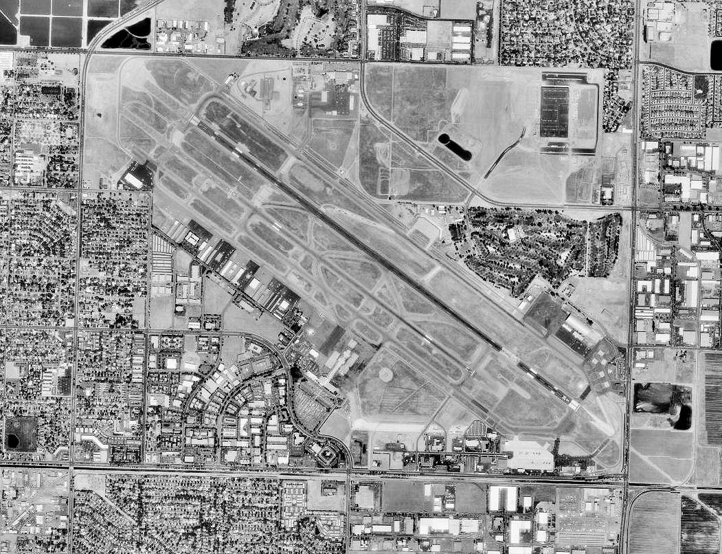
| Aerial image - 17 August 1998 |
| IATA: FAT – ICAO: KFAT – FAA LID: FAT |
| Summary |
| Airport type |
Public / Military |
| Owner |
City of Fresno |
| Serves |
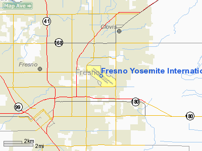
Fresno, California |
| Elevation AMSL |
336 ft / 102 m |
| Coordinates |
36°46′34″N 119°43′05″W / 36.77611°N 119.71806°W / 36.77611; -119.71806 |
| Website |
www.fresno.gov/... |
| Runways |
| Direction |
Length |
Surface |
| ft |
m |
| 11L/29R |
9,227 |
2,812 |
Asphalt |
| 11R/29L |
7,205 |
2,196 |
Asphalt |
| Helipads |
| Number |
Length |
Surface |
| ft |
m |
| H1 |
70 |
21 |
Asphalt |
| Statistics (2008) |
| Aircraft operations |
104,195 |
| Based aircraft |
208 |
| Source: Federal Aviation Administration |
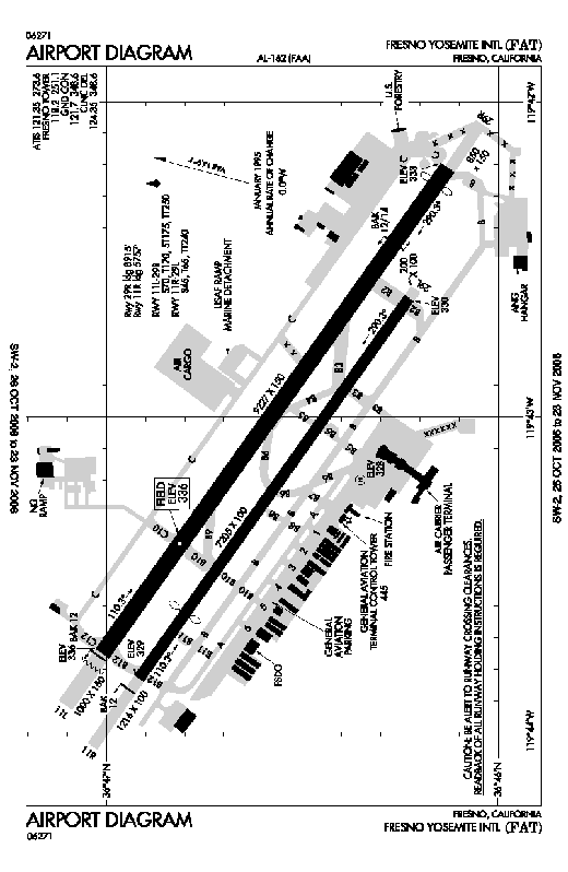 | |
FAA diagram of FAT |
Fresno Yosemite International Airport (IATA: FAT, ICAO: KFAT, FAA LID: FAT), often called FYI, formerly known as Fresno Air Terminal, is a joint civil-military public airport located in eastern Fresno, in Fresno County, California. The airport is over 60 miles (97 km) away from Yosemite National Park, which lies directly north of the city, on California State Route 41. The airport covers 2,150 acres (8.7 km²) and has two runways and one helipad. It is the major air transportation center for the San Joaquin Valley, with major air carrier service to airline hubs throughout the Western United States, as well as direct international flights to Guadalajara, Mexico. It is also home to Fresno Air National Guard Base and the 144th Fighter Wing (144 FW) of the California Air National Guard. Fresno was the ninth (9th) busiest international route out of Guadalajara International Airport in 2009. History
World War II
The airfield was opened in June 1942. During World War II the airfield was known as Hammer Field and was used by the United States Army Air Forces' Fourth Air Force. Hammer Field was a training base and had three sub-bases and two gunnery ranges.
Hammer Field also had an Army Air Forces regional hospital. The Army Air Force acquired this area for the Airways Detachment to set up a sub-base of Camp Pinedale for an extension of ordnance storage facilities and additional land for housing construction, a hospital, laundry, drainage facilities, cold storage, fire station, school building, rifle ranges, high tower shot gun range, motor pool areas, chemical warfare storage area, and a concrete underground igloo magazine arms storage.
Known Army Air Force units at Hammer Field were:
- 84th, 85th, 86th, 97th Bombardment Squadron (Light)
- 402nd Army Air Forces Base Unit (Fighter) (318th Wing)
- 450th Army Air Forces Base Unit (Combat Crew Training Station-Night Fighter)
- 15th Air Force, 456th Bomb Group, 745th Squadron, 15th Crew (B-24 Bombers)
On 1 January 1944, a Night Fighter school began operations at Hammer Field, with IV Fighter Command activating the 426th Night Fighter Squadron at the field under the 481st Night Fighter Operational Training Group. The unit operated P-70s and P-61 Black Widows and flew training missions in the Bakersfield area. With their training as a unit completed, the 426th NFS packed their bags and left California in mid-June 1944 for duty in India as part of Tenth Air Force. The 481st remained at Hammer Field as a training organization with P-70s and night-equipped P-38 Lightnings until being inactivated in April 1945.
With the end of the war in September 1945, Hammer Field was inactivated and was disposed of though the War Assets Administration (WAA). By 1949 the facility was completely in civil hands; the sources included the City of Fresno (804.59 acres by lease), 21 individual land owners (781.96 acres by fee and 27.24 acres (110,200 m) by lease), easement right-of-ways (1.42 acres) and permit (1.64 acres). In 1943 the lease on 9.24 acres (37,400 m) was terminated. In 1945 and 1946, the leases for 18 acres (73,000 m) and 5 acres (20,000 m) were terminated, respectively. Effective January 15, 1947, 23.06 acres (93,300 m) were reassigned for the Hammer Field National Guard training area. In 1948, 319 acres (1.29 km) were quitclaimed and the lease on 799.69 acres (3.2362 km) were transferred to the City of Fresno. In 1948 and 1949, 441.5 acres (1.787 km) were quitclaimed to the State of California.
Air National Guard use
The airfield was renamed Fresno Air Terminal, and retained a military cantonement area for the an Army Air Forces unit of the National Guard that became a unit of the Air National Guard when the U.S. Air Force was established as a separate service in 1947.
Today the California Air National Guard's 144th Fighter Wing (144 FW) occupies two separate parcels of land at the airport. (the main base area and the Munitions Storage Area). These areas of the airport are known as the Fresno Air National Guard Base.
Operationally-gained by the Air Combat Command (ACC), the mission of the 144th FW is to provide air defense protection for California from the Mexican border to Oregon utilizing F-16 Fighting Falcon aircraft. The 144th FW occupies 6 administrative, 16 industrial and 2 services buildings totaling approximately 341,251 square feet (31,703.3 m) with 325 full-time personnel, primarily Active Guard and Reserve (AGR) and Air Reserve Technician (ART) personnel. A unit training drill is conducted once a month and results in a surge of up to a total of 990 personnel when "traditional" part-time air national guardsmen are included. The part-time personnel, particularly pilots, also perform additional drills, additional flying training periods and/or additional active duty every month throughout the year.
The Composite Support Facility completed in late 2001 added an additional 6,236 square feet (579.3 m) of building area.
In addition to its Fresno ANGB facility, the 144 FW also maintains a permanent F-16 alert detachment/operating location (OL) at March Air Reserve Base, near Riverside, California.
Civil use
In 1988 the FAA designated the airport as an "International Point of Entry", making it eligible for international flights.
In 1995 the name was changed to attract out-of-state and international visitors to Yosemite National Park. Since its opening, the airport has gone through multiple renovations and expansions. In 2002 a new two-level Concourse building was completed and in 2006 construction of a new Federal Inspection Facility (FIS) was completed. The airport applied for a new FAA identifier code when its name was changed in 1996; however, the FAA will only assign a new airport identifier code when an airport physically moves to another location, such as in 1995 when Denver Airport moved from Stapleton (DIA to DEN).
Fresno has also served as headquarters for at least two airlines. Roughly 1996-1998, Air 21 flew Fokker F28 jets to various destinations; as far east as Colorado Springs, and as far west as San Francisco. Allegiant Air also called Fresno home, but has since moved its headquarters to Las Vegas.
In the 1980s, Fresno saw a variety of mainline aircraft, but throughout the 1990s, there was a shift to mainly regional aircraft. There has recently been more mainline aircraft returning to Fresno; including the long standing service to Dallas/Ft. Worth on American Airlines, Allegiant Air, and US Airways offer mainline service to Fresno. Delta Airlines announced service to Fresno from Atlanta, but this was later recanted. Frontier Airlines ended service as of June 2007, after 2 years of steady service.
Facilities and aircraft
Fresno Yosemite International Airport covers an area of 1,728 acres (699 ha) at an elevation of 336 feet (102 m) above mean sea level. It has two asphalt paved runways: 11L/29R is 9,227 by 150 feet (2,812 x 46 m) and 11R/29L is 7,205 by 100 feet (2,196 x 30 m). It also has one helipad designated H1 which measures 70 by 70 feet (21 x 21 m).
For the 12-month period ending September 30, 2008, the airport had 104,195 aircraft operations, an average of 285 per day: 65% general aviation, 18% air taxi, 11% scheduled commercial, and 6% military. At that time there were 208 aircraft based at this airport: 44% single-engine, 22% multi-engine, 6% jet, 11% helicopter and 18% military.
Passenger totals
Fresno completed 2006 with 1.281 million passengers traveling through Fresno Yosemite International Airport, an increase of 7.54% over 2005.
Fresno completed 2007 with 1.382 million passengers traveling through Fresno Yosemite International Airport, an increase of 3.13% over 2006.
The most prominent airlines at Fresno are Skywest Airlines for United Express and Delta Connection (36.29%), Mesa Airlines for US Airways Express (16.97%), American Airlines (12.77%), and Horizon Air (9.92%).
Airlines and destinations
| Airlines |
Destinations |
| Allegiant Air |
Las Vegas |
| American Airlines |
Dallas/Fort Worth |
| American Eagle |
Los Angeles |
| Delta Connection operated by SkyWest Airlines |
Salt Lake City |
| Horizon Air |
Portland (OR), Seattle/Tacoma |
| United Express operated by SkyWest Airlines |
Denver, Las Vegas, Los Angeles, San Francisco |
| US Airways |
Phoenix [seasonal] |
| US Airways Express operated by Mesa Airlines |
Las Vegas, Phoenix |
Cargo
| Airlines |
Destinations |
| ABX Air |
|
| Ameriflight |
Oakland, Visalia, Santa Maria |
| FedEx Express |
Oakland |
| UPS Airlines |
Ontario |
Quick facts
- Airport covers 2,300 acres (9.3 km²)
- WiFi access available throughout airport.
- FAT was the first airport in the country to implement an anti-terrorist facial recognition system, shortly after the September 11, 2001 attacks.
- The first airport in the Nation to install a web-based, wireless system (PASSUR Flight Information Display) to list active flight arrivals and departures.
- The Category IIIB Landing System is one of the most sophisticated in the nation, necessary when navigating through the Valley's winter tule fog.
- The vast majority of air traffic in and out of the airport is private aircraft. Only 7% of the air traffic is commercial, 6% is military, and the remainder is private.
- The 144th Fighter Wing of the California Air National Guard is based out of the Fresno Yosemite International Airport.[1]
- The California Army National Guard maintains an Aviation Classification Repair Activity Depot (AVCRAD) at the airport. The mission of this unit is to perform high level maintenance and repair on Army aircraft. Its jurisdiction covers a 15-state region in the Western United States.
- Both the U.S. Forest Service and the California Department of Forestry operate an Air Attack Base at the airport for fighting forest fires with aerial tankers.
Solar power
Fresno Yosemite International features a 2.4 megawatt solar system, completed in March 2008. The airport purchases solar-generated electricity from the system, which is owned, operated, and maintained by Solar Power Partners and its investors. Solar Power Partners contracted WorldWater & Solar Technologies Corp to construct the system. The solar system was financed through a solar Power Purchase Agreement, which required no capital outlay from the airport. At the time of commissioning, the system was the largest airport solar system in the nation.
The above content comes from Wikipedia and is published under free licenses – click here to read more.
Location
& QuickFacts
|
FAA
Information Effective: |
2006-06-08 |
|
Airport
Identifier: |
FAT |
|
Longitude/Latitude: |
119-43-05.3000W/36-46-34.3000N
-119.718139/36.776194 (Estimated) |
|
Elevation: |
336 ft / 102.41 m (Surveyed) |
|
Land: |
2150 acres |
|
From
nearest city: |
5 nautical miles NE of Fresno, CA |
|
Location: |
Fresno County, CA |
|
Magnetic Variation: |
14E (2005) |
Owner
& Manager
|
Ownership: |
Publicly owned |
|
Owner: |
City Of Fresno |
|
Address: |
4995 E Clinton Way
Fresno, CA 93727 |
|
Phone
number: |
559-621-4500 |
|
Manager: |
Russell C. Widmar, A.a.e.
DIRECTOR OF AVIATION |
|
Address: |
4995 E Clinton Way
Fresno, CA 93727 |
|
Phone number: |
559-621-4500 |
Airport
Operations and Facilities
|
Airport
Use: |
Open to public |
|
Wind
indicator: |
Yes |
|
Segmented
Circle: |
Yes |
|
Control
Tower: |
Yes |
|
Attendance
Schedule: |
ALL/ALL/ALL |
|
Lighting
Schedule: |
DUSK-DAWN |
|
Beacon
Color: |
Clear-Green (lighted land airport) |
|
Sectional
chart: |
San Francisco |
|
Region: |
AWP - Western-Pacific |
|
Traffic
Pattern Alt: |
967 ft |
|
Boundary
ARTCC: |
ZOA - Oakland |
|
Tie-in
FSS: |
RIU - Rancho Murieta |
|
FSS
on Airport: |
No |
|
FSS
Phone: |
916-354-0161 |
|
FSS
Toll Free: |
1-800-WX-BRIEF |
|
NOTAMs
Facility: |
FAT (NOTAM-d service avaliable) |
|
Certification type/date: |
I BS 5/1973 |
|
Federal Agreements: |
NGPY |
Airport
Communications
Airport
Services
|
Fuel
available: |
100 A |
|
Airframe
Repair: |
MAJOR |
|
Power
Plant Repair: |
MAJOR |
|
Bottled
Oxygen: |
HIGH/LOW |
|
Bulk
Oxygen: |
HIGH |
|
Runway Information
Runway 11L/29R
|
Dimension: |
9217 x 150 ft / 2809.3 x 45.7 m |
|
Surface: |
ASPH, Good Condition |
|
Surface
Treatment: |
Saw-cut or plastic Grooved |
|
Weight
Limit: |
Single wheel: 70000 lbs.
Dual wheel: 170000 lbs.
Dual
tandem wheel: 250000 lbs. |
|
Edge
Lights: |
High |
|
|
Runway 11L |
Runway 29R |
|
Longitude: |
119-43-45.0680W |
119-42-12.6794W |
|
Latitude: |
36-47-00.5601N |
36-46-07.8172N |
|
Elevation: |
333.00 ft |
332.00 ft |
|
Alignment: |
125 |
127 |
|
ILS
Type: |
LOC/DME
|
ILS/DME
|
|
Traffic
Pattern: |
Left |
Right |
|
Markings: |
Precision instrument, Good Condition |
Precision instrument, Good Condition |
|
Arresting: |
BAK12 |
BAK12 |
|
Crossing
Height: |
0.00 ft |
75.00 ft |
|
Displaced
threshold: |
0.00 ft |
312.00 ft |
|
VASI: |
|
4-light PAPI on left side |
|
Visual
Glide Angle: |
0.00� |
3.00� |
|
RVR
Equipment: |
touchdown, midfield, rollout |
touchdown, midfield, rollout |
|
Approach
lights: |
|
ALSF2 |
|
Runway
End Identifier: |
Yes |
No |
|
Centerline
Lights: |
Yes |
Yes |
|
Touchdown
Lights: |
No |
Yes |
|
Obstruction: |
31 ft pole, 1360.0 ft from runway, 650 ft left
of centerline, 37:1 slope to clear |
16 ft road, 750.0 ft from runway, 580 ft right
of centerline, 34:1 slope to clear |
|
Runway 11R/29L
|
Dimension: |
7205 x 100 ft / 2196.1 x 30.5 m |
|
Surface: |
ASPH, Good Condition |
|
Weight
Limit: |
Single wheel: 70000 lbs.
Dual wheel: 125000 lbs.
Dual
tandem wheel: 200000 lbs. |
|
Edge
Lights: |
Medium |
|
|
Runway 11R |
Runway 29L |
|
Longitude: |
119-43-49.7002W |
119-42-37.4762W |
|
Latitude: |
36-46-55.0149N |
36-46-13.7904N |
|
Elevation: |
329.00 ft |
330.00 ft |
|
Alignment: |
125 |
127 |
|
Traffic
Pattern: |
Right |
Left |
|
Markings: |
Basic, Good Condition |
Basic, Good Condition |
|
Crossing
Height: |
0.00 ft |
44.00 ft |
|
Displaced
threshold: |
1448.00 ft |
0.00 ft |
|
VASI: |
|
4-light PAPI on left side |
|
Visual
Glide Angle: |
0.00� |
3.00� |
|
Runway
End Identifier: |
Yes |
|
|
Centerline
Lights: |
No |
No |
|
Touchdown
Lights: |
No |
No |
|
Helipad H1
|
Dimension: |
70 x 70 ft / 21.3 x 21.3 m |
|
Surface: |
ASPH, Good Condition |
|
Weight
Limit: |
Single wheel: 60000 lbs.
Dual wheel: 110000 lbs. |
|
|
Runway H1 |
Runway |
|
Traffic
Pattern: |
Left |
Left |
|
Markings: |
Basic, |
, |
|
Radio Navigation
Aids
|
ID |
Type |
Name |
Ch |
Freq |
Var |
Dist |
|
CUK |
NDB |
Academy |
|
266.00 |
14E |
4.8 nm |
|
FCH |
NDB |
Chandler |
|
344.00 |
15E |
6.4 nm |
|
COR |
NDB |
Salyer Farms |
|
205.00 |
16E |
43.6 nm |
|
NLC |
TACAN |
Lemoore |
080X |
|
16E |
28.6 nm |
|
VIS |
VOR/DME |
Visalia |
031X |
109.40 |
16E |
27.1 nm |
|
HYP |
VOR/DME |
El Nido |
089X |
114.20 |
15E |
42.2 nm |
|
CZQ |
VORTAC |
Clovis |
076X |
112.90 |
15E |
8.0 nm |
|
FRA |
VORTAC |
Friant |
103X |
115.60 |
17E |
20.6 nm |
Remarks
- 1000'
STWY RY 29R; 850' STWY RY 11L; 1216' STWY RY 29L; 200' STWY RY 11R.
- (E60-29L)
BAK-12 1216'.
- NUMEROUS
BIRDS INVOF ARPT.
- TWY
B5 BTN RY 11L/29R & 11R/29L UNLGTD RETROREFLECTIVE MARKERS RSTRD
TO ACFT 12500 LBS OR LESS.
-
< LBS
60000 OVER ACFT RQRD APVL PRIOR WIDE; FT 40 A; TWY>
- NO
INTERSECTION DEPS TO THE NW EXCP THE INTERSECTION OF RY 29R AT TWY B2
OR DURG SNGL RY OPNS.
- FRESNO
YOSEMITE INTL IS NOISE SENSITIVE; NOISE ABATEMENT PROCEDURES IN EFFECT.
- LGTD
RY DSTC REMAINING SIGNS S SIDE OF RY 11R/29L; LGTD RY DSTC REMAINING
SIGNS BOTH SIDES OF RY 11L/29R.
- NO
MULT APCHS AND LNDGS 2200-0700 MONDAY THRU SATURDAY; 1800-1000 SUNDAY.
- MIL
BAK-14 IN PAVEMENT ARRESTING CABLE 1634' NW OF RY 29 THR; BAK 12 ARRESTING
CABLE ON RY 29L & 29R STWYS.
- PSBL
WAKE TURBULENCE OR WIND SHEAR ARR TO RY 29L OR DEP FM RY 11R. JET TESTING
CONDUCTED AT AIR NATIONAL GUARD RAMP LCTD AT SE CORNER OF ARPT.
Based Aircraft
|
Aircraft
based on field: |
229 |
|
Single
Engine Airplanes: |
122 |
|
Multi
Engine Airplanes: |
43 |
|
Jet Engine
Airplanes: |
10 |
|
Helicopters: |
12 |
|
Military: |
42 |
Major Carriers
Serving This Airport
| Sky West Airlines |
74.1% |
| American Eagle Airlines |
20.6% |
| American Airlines |
5.2% |
Most Popular Destinations
| Los Angeles Intl (LAX) |
43.6% |
| San Francisco International (SFO) |
17.9% |
|
Salt Lake City Intl (SLC) |
11.4% |
| Denver Intl (DEN) |
9.3% |
| Mc Carran Intl (LAS) |
7.8% |
|
Dallas/fort Worth International (DFW) |
5.2% |
| Visalia Muni (VIS) |
4.7% |
|
City Of Colorado Springs Muni (COS) |
0.0% |
|
Joslin Field - Magic Valley Rgnl (TWF) |
0.0% |
Most Popular Aircraft
|
N394AE |
2.0% |
| N390AE |
1.9% |
|
N393AE |
1.9% |
| N370AM |
1.9% |
|
N389AE |
1.8% |
| N901AE |
1.7% |
|
N392AE |
1.7% |
| N250YV |
1.7% |
|
N388AE |
1.6% |
| N396AE |
1.6% |
Operational Statistics
|
Aircraft
Operations: |
485/Day |
|
Air Carrier: |
6.2% |
|
Air Taxi: |
23.9% |
|
General
Aviation Local: |
12.8% |
|
General
Aviation Itinerant: |
44.8% |
|
Military: |
6.0% |
Fresno Yosemite International Airport
Address:
Fresno County, CA
Tel:
559-621-4500
Images
and information placed above are from
http://www.airport-data.com/airport/FAT/
We
thank them for the data!
| General
Info |
| Country |
United
States |
| State |
CALIFORNIA
|
| FAA ID |
FAT
|
| Latitude |
36-46-34.300N
|
| Longitude |
119-43-05.300W
|
| Elevation |
336 feet
|
| Near City |
FRESNO
|
We don't guarantee the information is fresh and accurate. The data may
be wrong or outdated.
For more up-to-date information please refer to other sources.
|
|