|
|
Fresno Chandler Executive Airport |
| Fresno Chandler Executive Airport |
 |
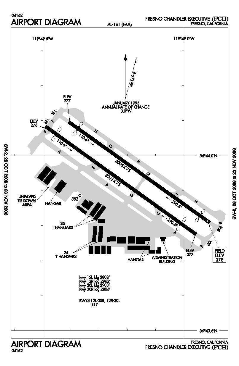
| FAA airport diagram |
| IATA: FCH – ICAO: KFCH – FAA LID: FCH |
| Summary |
| Airport type |
Public |
| Owner |
City of Fresno |
| Serves |
Fresno, California |
| Elevation AMSL |
279 ft / 85 m |
| Coordinates |
36°43′56″N 119°49′13″W / 36.73222°N 119.82028°W / 36.73222; -119.82028 |
| Runways |
| Direction |
Length |
Surface |
| ft |
m |
| 12/30 |
3,630 |
1,106 |
Asphalt |
| Statistics (2007) |
| Aircraft operations |
25,000 |
| Based aircraft |
126 |
| Source: Federal Aviation Administration |
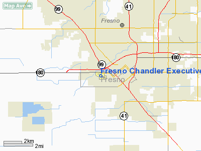
Fresno Chandler Executive Airport (IATA: FCH, ICAO: KFCH, FAA LID: FCH) is a public use airport located two nautical miles (3.7 km) west of the central business district of Fresno, a city in Fresno County, California, United States. It is owned by the City of Fresno.
Chandler is a general aviation airport serving the central San Joaquin Valley. Scheduled airline service is provided at the city owned airport, Fresno Yosemite International Airport, located 6 miles (8 km) northeast. Sierra Sky Park Airport, a privately owned airport opened to the public, is located 22 km (14 mi) north.
Facilities and aircraft
Fresno Chandler Executive Airport covers an area of 200 acres (81 ha) at an elevation of 279 feet (85 m) above mean sea level. It has one asphalt paved runway designated 12/30 which measures 3,630 by 75 feet (1,106 x 23 m).
For the 12-month period ending March 2, 2007, the airport had 25,000 general aviation aircraft operations, an average of 68 per day. At that time there were 126 aircraft based at this airport: 83% single-engine, 6% multi-engine, 1% jet, 4% helicopter, 6% ultralight.
The above content comes from Wikipedia and is published under free licenses – click here to read more.
Location
& QuickFacts
|
FAA
Information Effective: |
2006-06-08 |
|
Airport
Identifier: |
FCH |
|
Longitude/Latitude: |
119-49-11.6260W/36-43-56.5140N
-119.819896/36.732365 (Estimated) |
|
Elevation: |
278 ft / 84.73 m (Surveyed) |
|
Land: |
200 acres |
|
From
nearest city: |
2 nautical miles W of Fresno, CA |
|
Location: |
Fresno County, CA |
|
Magnetic Variation: |
15E (1985) |
Owner
& Manager
|
Ownership: |
Publicly owned |
|
Owner: |
City Of Fresno |
|
Address: |
4995 E. Clinton Way
Fresno, CA 93727-1525 |
|
Phone
number: |
559-498-4500 |
|
Manager: |
Dan Card |
|
Address: |
510 West Kearney Blvd
Fresno, CA 93706 |
|
Phone number: |
559-621-4513 |
Airport
Operations and Facilities
|
Airport
Use: |
Open to public |
|
Wind
indicator: |
Yes |
|
Segmented
Circle: |
Yes |
|
Control
Tower: |
No |
|
Attendance
Schedule: |
ALL/ALL/0800-1700 |
|
Lighting
Schedule: |
DUSK-DAWN
ACTVT MIRL RY 12R/30L REIL RY 12R & 30L AND TWY LGTS.
- CTAF. |
|
Beacon
Color: |
Clear-Green (lighted land airport) |
|
Sectional
chart: |
San Francisco |
|
Region: |
AWP - Western-Pacific |
|
Boundary
ARTCC: |
ZOA - Oakland |
|
Tie-in
FSS: |
RIU - Rancho Murieta |
|
FSS
on Airport: |
No |
|
FSS
Phone: |
916-354-0161 |
|
FSS
Toll Free: |
1-800-WX-BRIEF |
|
NOTAMs
Facility: |
FCH (NOTAM-d service avaliable) |
|
Federal Agreements: |
NGY |
Airport
Communications
|
CTAF: |
123.000 |
|
Unicom: |
123.000 |
Airport
Services
|
Fuel
available: |
100LL
FUEL AVBL 0800-1700 DAILY. |
|
Airframe
Repair: |
MINOR |
|
Power
Plant Repair: |
MINOR |
|
Bulk
Oxygen: |
NONE |
|
Runway Information
Runway 12L/30R
|
Dimension: |
3006 x 75 ft / 916.2 x 22.9 m |
|
Surface: |
ASPH, Good Condition |
|
Weight
Limit: |
Single wheel: 17000 lbs. |
|
|
Runway 12L |
Runway 30R |
|
Longitude: |
119-49-24.5730W |
119-48-54.5720W |
|
Latitude: |
36-44-05.8550N |
36-43-48.5240N |
|
Elevation: |
277.00 ft |
278.00 ft |
|
Alignment: |
126 |
127 |
|
Traffic
Pattern: |
Left |
Right |
|
Markings: |
Basic, Fair Condition |
Basic, Fair Condition |
|
Displaced
threshold: |
198.00 ft |
200.00 ft |
|
Runway
End Identifier: |
No |
No |
|
Centerline
Lights: |
No |
No |
|
Touchdown
Lights: |
No |
No |
|
Obstruction: |
14 ft road, 350.0 ft from runway, 140 ft left
of centerline, 10:1 slope to clear
APCH RATIO 39:1 FM DSPLCD THR. |
62 ft trees, 1200.0 ft from runway, 260 ft
right of centerline, 16:1 slope to clear
APCH RATIO 24:1 TO DSPLCD THLD. |
|
Runway 12R/30L
|
Dimension: |
3202 x 75 ft / 976.0 x 22.9 m |
|
Surface: |
ASPH, Good Condition |
|
Weight
Limit: |
Single wheel: 17000 lbs. |
|
Edge
Lights: |
Medium |
|
|
Runway 12R |
Runway 30L |
|
Longitude: |
119-49-29.4400W |
119-48-57.4840W |
|
Latitude: |
36-44-05.0140N |
36-43-46.5550N |
|
Elevation: |
276.00 ft |
277.00 ft |
|
Alignment: |
126 |
127 |
|
Traffic
Pattern: |
Right |
Left |
|
Markings: |
Non-precision instrument, Fair Condition |
Non-precision instrument, Fair Condition |
|
Displaced
threshold: |
240.00 ft |
299.00 ft |
|
VASI: |
2-box on left side |
4-light PAPI on right side |
|
Runway
End Identifier: |
Yes |
Yes |
|
Centerline
Lights: |
No |
No |
|
Touchdown
Lights: |
No |
No |
|
Obstruction: |
15 ft road, 450.0 ft from runway, 150 ft left
of centerline, 16:1 slope to clear
APCH RATIO 46:1 FM DSPLCD THR. |
15 ft road, 360.0 ft from runway, 140 ft left
of centerline, 10:1 slope to clear
APCH RATIO 43:1 FM DSPLCD THR. |
|
Radio Navigation
Aids
|
ID |
Type |
Name |
Ch |
Freq |
Var |
Dist |
|
FCH |
NDB |
Chandler |
|
344.00 |
15E |
0.8 nm |
|
CUK |
NDB |
Academy |
|
266.00 |
14E |
8.9 nm |
|
COR |
NDB |
Salyer Farms |
|
205.00 |
16E |
42.3 nm |
|
NLC |
TACAN |
Lemoore |
080X |
|
16E |
24.4 nm |
|
VIS |
VOR/DME |
Visalia |
031X |
109.40 |
16E |
27.3 nm |
|
HYP |
VOR/DME |
El Nido |
089X |
114.20 |
15E |
40.4 nm |
|
CZQ |
VORTAC |
Clovis |
076X |
112.90 |
15E |
9.1 nm |
|
FRA |
VORTAC |
Friant |
103X |
115.60 |
17E |
24.8 nm |
|
PXN |
VORTAC |
Panoche |
073X |
112.60 |
16E |
46.2 nm |
Remarks
- NMRS
BIRDS INVOF ARPT.
- PRACTICE
LDGS & LOW APCHS & TGL OR STOP-AND-GO OPNS AUTH ONLY BTN 0700-2200.
- RY
30L & RY 30R CALM WIND RY WHEN WIND REPORTED BY AWOS LESS THAN 5
KNOTS.
- RY
12L & RY 12R PRACTICE LDGS & LOW APCHS & TGL OR STOP-AND-GO
OPNS NOT PERMITTED DUE TO NOISE SENSITIVE RESIDENTIAL AREAS SE OF ARPT.
- AFT
TKOF CLIMB ON RY HEADING UNTIL PASSING 800 FT MSL; FOR SAFETY &
NOISE ABATEMENT INITIAL CLIMBOUT AT BEST RATE-OF-CLIMB RECOMMENDED.
- AWOS
CEILING UNRELIABLE.
Based Aircraft
|
Aircraft
based on field: |
234 |
|
Single
Engine Airplanes: |
215 |
|
Multi
Engine Airplanes: |
11 |
|
Ultralights: |
8 |
Operational Statistics
|
Aircraft
Operations: |
69/Day |
|
General
Aviation Local: |
76.0% |
|
General
Aviation Itinerant: |
24.0% |
Fresno Chandler Executive Airport
Address:
Fresno County, CA
Tel:
559-498-4500,
559-621-4513
Images
and information placed above are from
http://www.airport-data.com/airport/FCH/
We
thank them for the data!
| General
Info |
| Country |
United
States |
| State |
CALIFORNIA
|
| FAA ID |
FCH
|
| Time |
UTC-8(-7DT)
|
| Latitude |
36.732364
36� 43' 56.51" N |
| Longitude |
-119.819897
119� 49' 11.63" W |
| Elevation |
278 feet
85 meters |
| Type |
Civil
|
| Magnetic
Variation |
014� E
(01/06) |
| Beacon |
Yes
|
| Operating
Agency |
U.S.CIVIL
AIRPORT WHEREIN PERMIT COVERS USE BY TRANSIT MILITARY AIRCRAFT
|
| Operating
Hours |
SEE REMARKS
FOR OPERATING HOURS OR COMMUNICATIONS FOR POSSIBLE HOURS |
| Daylight
Savings Time |
First
Sunday in April at 0200 to last Sunday in October at 0200 local time
(Exception Arizona and that portion of Indiana in the Eastern Time
Zone) |
We don't guarantee the information is fresh and accurate. The data may
be wrong or outdated.
For more up-to-date information please refer to other sources.
|
|