 |
|
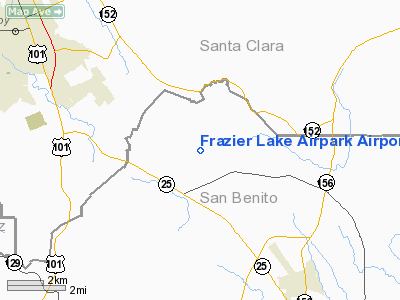
Frazier Lake Airpark Airport |
| Frazier Lake Airpark |
| IATA: none – ICAO: none – FAA LID: 1C9 |
| Summary |
| Airport type |
Public |
| Operator |
Frazier Lake Airpark |
| Location |
Hollister, California |
| Elevation AMSL |
151 ft / 46 m |
| Coordinates |
36°57′12″N 121°27′56″W / 36.95333°N 121.46556°W / 36.95333; -121.46556Coordinates: 36°57′12″N 121°27′56″W / 36.95333°N 121.46556°W / 36.95333; -121.46556 |
| Runways |
| Direction |
Length |
Surface |
| ft |
m |
| 5/23 |
2,500 |
762 |
Grass |
| 5W/23W |
3,000 |
914 |
Water |
Frazier Lake Airpark (FAA LID: 1C9) is a small non-towered airport located near Hollister, in San Benito County, California, USA. It is unusual in that one of its runways is grass, and the other is water. On the first Saturday of each month the Airpark has an open house when it puts its antique and homebuilt aircraft on display to the public.
The above content comes from Wikipedia and is published under free licenses – click here to read more.
Location
& QuickFacts
|
FAA
Information Effective: |
2006-06-08 |
|
Airport
Identifier: |
1C9 |
|
Longitude/Latitude: |
121-27-55.7730W/36-57-11.8190N
-121.465492/36.953283 (Estimated) |
|
Elevation: |
151 ft / 46.02 m (Surveyed) |
|
Land: |
155 acres |
|
From
nearest city: |
8 nautical miles NW of Hollister, CA |
|
Location: |
San Benito County, CA |
|
Magnetic Variation: |
15E (1985) |
Owner
& Manager
|
Ownership: |
Privately owned |
|
Owner: |
Frazier Lake Airpark |
|
Address: |
Po Box 513
San Martin, CA 95046 |
|
Phone
number: |
831-634-0855 |
|
Manager: |
Bob Zeiher
PRESIDENT NOT LOCATED ON ARPT. |
|
Address: |
Po Box 513
San Martin, CA 95046 |
|
Phone number: |
408-374-0158 |
Airport
Operations and Facilities
|
Airport
Use: |
Open to public |
|
Wind
indicator: |
Yes |
|
Segmented
Circle: |
Yes |
|
Control
Tower: |
No |
|
Attendance
Schedule: |
ALL/SAT-SUN/0800-SS,ALL/MON-FRI/IREG |
|
Lighting
Schedule: |
RDO-CTL
ACTVT LIRL RWY 05/23 - CTAF. |
|
Landing
fee charge: |
No |
|
Sectional
chart: |
San Francisco |
|
Region: |
AWP - Western-Pacific |
|
Boundary
ARTCC: |
ZOA - Oakland |
|
Tie-in
FSS: |
OAK - Oakland |
|
FSS
on Airport: |
No |
|
FSS
Phone: |
510-273-6111 |
|
FSS
Toll Free: |
1-800-WX-BRIEF |
|
NOTAMs
Facility: |
OAK (NOTAM-d service avaliable) |
Airport
Communications
|
CTAF: |
123.050 |
|
Unicom: |
123.050 |
|
Runway Information
Runway 05/23
|
Dimension: |
2500 x 100 ft / 762.0 x 30.5 m |
|
Surface: |
TURF, Good Condition
WATER DEPTH NOTED AS SHALLOW AS 1 1/2 FEET DEEP. |
|
Edge
Lights: |
Low |
|
|
Runway 05 |
Runway 23 |
|
Traffic
Pattern: |
Left |
Right |
|
Runway
End Identifier: |
|
No |
|
Obstruction: |
40 ft pline, 1350.0 ft from runway, 33:1 slope
to clear |
, 50:1 slope to clear |
|
Runway 05W/23W
|
Dimension: |
3000 x 60 ft / 914.4 x 18.3 m |
|
Surface: |
WATER, Good Condition
WATER DEPTH NOTED AS SHALLOW AS 1 1/2 FEET DEEP. |
|
|
Runway 05W |
Runway 23W |
|
Traffic
Pattern: |
Left |
Right |
|
Obstruction: |
40 ft pline, 1100.0 ft from runway, 27:1 slope
to clear |
, 50:1 slope to clear |
|
Radio Navigation
Aids
|
ID |
Type |
Name |
Ch |
Freq |
Var |
Dist |
|
PDG |
NDB |
Pajar |
|
327.00 |
17E |
16.6 nm |
|
UAD |
NDB |
Chualar |
|
263.00 |
16E |
27.8 nm |
|
TCY |
NDB |
Tracy |
|
203.00 |
15E |
44.4 nm |
|
LV |
NDB |
Reiga |
|
374.00 |
16E |
45.6 nm |
|
NUQ |
TACAN |
Moffett |
123X |
|
17E |
40.4 nm |
|
SJC |
VOR/DME |
San Jose |
088X |
114.10 |
16E |
34.2 nm |
|
MOD |
VOR/DME |
Modesto |
093X |
114.60 |
17E |
47.2 nm |
|
SNS |
VORTAC |
Salinas |
120X |
117.30 |
17E |
18.6 nm |
|
PXN |
VORTAC |
Panoche |
073X |
112.60 |
16E |
36.0 nm |
|
OSI |
VORTAC |
Woodside |
086X |
113.90 |
17E |
47.2 nm |
|
BSR |
VORTAC |
Big Sur |
087X |
114.00 |
16E |
47.2 nm |
Remarks
- RY
05W/23W NOT MKD; TYPICAL WATER DEPTH 1.5'.
- RAMP
& DOCK FACILITIES AVBL.
- CAUTION:
SEAPLANE LANDING AREA /WATER CHANNEL/ 200' SOUTH OF ADJACENT/PARALLEL
GRASS RUNWAY.
- NO
PRACTICE TKOFS & LNDGS RY 05/23 WHEN WET OR SOFT.
- NO
MIDFIELD TAKEOFFS OR BACK-TAXI ON RUNWWAY 5/23.
- BURM
AND DITCH ADJACENT TO RUNWAY 5 APPROACH AND SEAPLANE TURN AROUND.
- PAEW
VCNTY OF RY 05/23 EVERY TUESDAY DURG DALGHT HRS.
- CONDL:
VFR USE ONLY.
Based Aircraft
|
Aircraft
based on field: |
91 |
|
Single
Engine Airplanes: |
87 |
|
Multi
Engine Airplanes: |
1 |
|
Ultralights: |
3 |
Operational Statistics
|
Aircraft
Operations: |
100/Week |
|
General
Aviation Local: |
42.3% |
|
General
Aviation Itinerant: |
57.7% |
Frazier Lake Airpark Airport
Address:
San Benito County, CA
Tel:
831-634-0855,
408-374-0158
Images
and information placed above are from
http://www.airport-data.com/airport/1C9/
We
thank them for the data!
| General
Info |
| Country |
United
States |
| State |
CALIFORNIA
|
| FAA ID |
1C9
|
| Latitude |
36-57-11.819N
|
| Longitude |
121-27-55.773W
|
| Elevation |
151 feet
|
| Near City |
HOLLISTER
|
We don't guarantee the information is fresh and accurate. The data may
be wrong or outdated.
For more up-to-date information please refer to other sources.
|
|


