 |
|
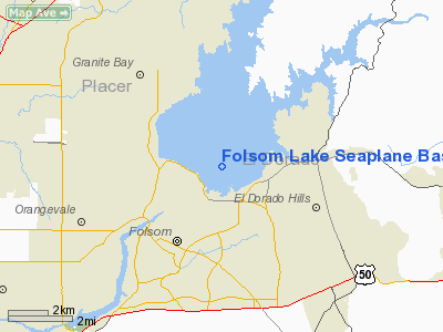
Folsom Lake Seaplane Base |
|
|
Location
& QuickFacts
|
FAA
Information Effective: |
2006-06-08 |
|
Airport
Identifier: |
C39 |
|
Longitude/Latitude: |
121-08-00.0000W/38-42-26.0000N
-121.133333/38.707222 (Estimated) |
|
Elevation: |
466 ft / 142.04 m (Estimated)
LAKE LEVEL VARIES FROM 350 FT TO 466 FT. NO LNDG OF SEAPLANES
OR ULTRALIGHTS WHEN LAKE ELEVATION IS BELOW 380 FT. CALL
BUREAU OF RECLAMATION FOR CURRENT LAKE ELEVATION AT 1-800-742-9474
EXT 102. |
|
Land: |
0 acres |
|
From
nearest city: |
1 nautical miles N of Folsom, CA |
|
Location: |
Sacramento County, CA |
|
Magnetic Variation: |
16E (1995) |
Owner
& Manager
|
Ownership: |
Publicly owned |
|
Owner: |
U.s. Bureau Of Reclamation |
|
Address: |
7794 Folsom-auburn Road
Folsom, CA 95630 |
|
Phone
number: |
916-988-0205 |
|
Manager: |
Bruce Kranz/dept Parks & Rec |
|
Address: |
7806 Folsom-auburn Road
Folsom, CA 95630 |
|
Phone number: |
916-988-0205 |
Airport
Operations and Facilities
|
Airport
Use: |
Open to public |
|
Wind
indicator: |
Yes
WIND INDICATOR IS MOUNTED ON A BUOY IN THE MIDDLE OF THE
LAKE. |
|
Segmented
Circle: |
No |
|
Control
Tower: |
No |
|
Attendance
Schedule: |
UNATNDD |
|
Sectional
chart: |
San Francisco |
|
Region: |
AWP - Western-Pacific |
|
Boundary
ARTCC: |
ZOA - Oakland |
|
Tie-in
FSS: |
RIU - Rancho Murieta |
|
FSS
on Airport: |
No |
|
FSS
Phone: |
916-354-0161 |
|
FSS
Toll Free: |
1-800-WX-BRIEF |
|
NOTAMs
Facility: |
RIU (NOTAM-d service avaliable) |
Airport
Communications
Airport Services
|
Fuel
available: |
MOGAS
FOR FUEL CALL (916) 933-1300 DURING DALGT HRS. |
|
Runway
Information
Runway ALL/WAY
|
Dimension: |
10000 x 4000 ft / 3048.0 x 1219.2 m |
|
Surface: |
WATER, |
|
|
Runway ALL |
Runway WAY |
|
Traffic
Pattern: |
Left |
Left |
|
Radio Navigation
Aids
|
ID |
Type |
Name |
Ch |
Freq |
Var |
Dist |
|
MY |
NDB |
Halow |
|
222.00 |
16E |
35.6 nm |
|
BAB |
TACAN |
Beale |
023X |
|
16E |
29.4 nm |
|
SUU |
TACAN |
Travis |
113X |
|
17E |
47.2 nm |
|
TZZ |
VOR |
Travis |
|
116.40 |
17E |
38.6 nm |
|
MCC |
VOR/DME |
Mc Clellan |
029X |
109.20 |
17E |
12.9 nm |
|
HNW |
VOR/DME |
Hangtown |
102X |
115.50 |
17E |
18.0 nm |
|
MYV |
VOR/DME |
Marysville |
045X |
110.80 |
16E |
31.3 nm |
|
SWR |
VOR/DME |
Squaw Valley |
079X |
113.20 |
16E |
49.4 nm |
|
SAC |
VORTAC |
Sacramento |
099X |
115.20 |
17E |
25.2 nm |
|
LIN |
VORTAC |
Linden |
095X |
114.80 |
17E |
38.5 nm |
|
ILA |
VORTAC |
Williams |
091X |
114.40 |
18E |
47.2 nm |
|
SAC |
VOT |
Sacramento Executive |
|
111.40 |
|
20.7 nm |
|
SMF |
VOT |
Sacramento Metropolitan |
|
111.40 |
|
21.5 nm |
Remarks
- LAND
& TAKEOFF ONLY AT THE MAIN LAKE.
- STAY
2000 FT AWAY FROM ALL SHORELINES.
- BEACHING
OF ACFT ONLY ON SHORELINE OF PENINSULA & UNOCCUPIED AREAS. NO BEACHING
ON DAY USE AREAS AT DYKE 8; BEAL'S POINT & GRANITE BAY.
- POWER
LINES S OF MAIN LAKE & ALONG RIDGE 1000 YARDS FROM SHORELINE.
- PARAGLIDER
ACTIVITY ON LAKE UP TO 3000 FT ABV SURFACE OF LAKE. PILOTS BE AWARE
OF TOW LINES.
- PRVDD
VFR; SPONSOR SHALL ENSURE OBSTN-FREE INGRESS & EGRESS AND OBTAIN
PERMITS FROM THE APPLICABLE GOVERNMENT AGENCY.
Folsom Lake Seaplane Base
Address:
Sacramento County, CA
Tel:
916-988-0205
Images
and information placed above are from
http://www.airport-data.com/airport/C39/
We
thank them for the data!
| General
Info |
| Country |
United
States |
| State |
CALIFORNIA
|
| FAA ID |
C39
|
| Latitude |
38-42-26.000N
|
| Longitude |
121-08-00.000W
|
| Elevation |
466 feet
|
| Near City |
FOLSOM
|
We don't guarantee the information is fresh and accurate. The data may
be wrong or outdated.
For more up-to-date information please refer to other sources.
|
|


