 |
|
Fallbrook Community Airpark Airport |
| Fallbrook Community Airpark |
| IATA: none – ICAO: none – FAA LID: L18 |
| Summary |
| Airport type |
Public |
| Owner |
County of San Diego |
| Serves |
Fallbrook, California |
| Elevation AMSL |
708 ft / 216 m |
| Coordinates |
33°21′15″N 117°15′03″W / 33.35417°N 117.25083°W / 33.35417; -117.25083 |
| Runways |
| Direction |
Length |
Surface |
| ft |
m |
| 18/36 |
2,160 |
658 |
Asphalt |
| Statistics (2005) |
| Aircraft operations |
36,125 |
| Based aircraft |
97 |
| Source: Federal Aviation Administration |
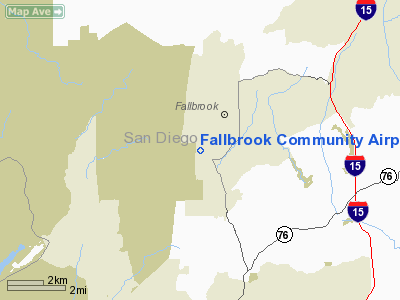
Fallbrook Community Airpark (FAA LID: L18), also known as Fallbrook Airpark, is a county-owned public-use airport located two nautical miles (3.7 km) south of the central business district of Fallbrook, in San Diego County, California, United States.
Facilities and aircraft
Fallbrook Community Airpark covers an area of 290 acres (117 ha) at an elevation of 708 feet (216 m) above mean sea level. It has one runway designated 18/36 with an asphalt surface measuring 2,160 by 60 feet (658 x 18 m).
For the 12-month period ending December 31, 2005, the airport had 36,125 general aviation aircraft operations, an average of 98 per day. At that time there were 97 aircraft based at this airport: 92% single-engine, 6% multi-engine and 2% helicopter.
The above content comes from Wikipedia and is published under free licenses – click here to read more.
Location
& QuickFacts
|
FAA
Information Effective: |
2006-06-08 |
|
Airport
Identifier: |
L18 |
|
Longitude/Latitude: |
117-15-03.1270W/33-21-15.1130N
-117.250869/33.354198 (Estimated) |
|
Elevation: |
708 ft / 215.80 m (Estimated) |
|
Land: |
290 acres |
|
From
nearest city: |
2 nautical miles S of Fallbrook, CA |
|
Location: |
San Diego County, CA |
|
Magnetic Variation: |
13E (1985) |
Owner
& Manager
|
Ownership: |
Publicly owned |
|
Owner: |
County Of San Diego |
|
Address: |
1960 Joe Crosson Drive
El Cajon, CA 92020-1235 |
|
Phone
number: |
619-956-4800 |
|
Manager: |
Bo Donovan |
|
Address: |
2155 South Mission Road
Fallbrook, CA 92028 |
|
Phone number: |
760-723-8395 |
Airport
Operations and Facilities
|
Airport
Use: |
Open to public |
|
Wind
indicator: |
Yes |
|
Segmented
Circle: |
Yes |
|
Control
Tower: |
No |
|
Attendance
Schedule: |
ALL/ALL/0800-1700 |
|
Lighting
Schedule: |
DUSK-DAWN
MIRL RY 18/36 MED INTST ONLY AVBL. ACTVT MIRL RY 18/36 &
TWY LGTS - CTAF. |
|
Beacon
Color: |
Clear-Green (lighted land airport) |
|
Landing
fee charge: |
No |
|
Sectional
chart: |
Los Angeles |
|
Region: |
AWP - Western-Pacific |
|
Traffic
Pattern Alt: |
1000 ft |
|
Boundary
ARTCC: |
ZLA - Los Angeles |
|
Tie-in
FSS: |
SAN - San Diego |
|
FSS
on Airport: |
No |
|
FSS
Phone: |
858-277-7043 |
|
FSS
Toll Free: |
1-800-WX-BRIEF |
|
NOTAMs
Facility: |
SAN (NOTAM-d service avaliable) |
|
Federal Agreements: |
NPSY |
Airport
Communications
|
CTAF: |
123.050 |
|
Unicom: |
123.050
AUTOMATED UNICOM - 3 CLICKS FOR ARPT ADVISORY & WEATHER,
4 CLICKS FOR RADIO CHECK. |
Airport
Services
|
Fuel
available: |
100LL |
|
Airframe
Repair: |
MAJOR |
|
Power
Plant Repair: |
MAJOR |
|
Bottled
Oxygen: |
NONE |
|
Bulk
Oxygen: |
NONE |
|
Runway Information
Runway 18/36
|
Dimension: |
2160 x 60 ft / 658.4 x 18.3 m |
|
Surface: |
ASPH, Good Condition |
|
Surface
Treatment: |
Rubberized Friction Seal Coat |
|
Weight
Limit: |
Single wheel: 12000 lbs. |
|
Edge
Lights: |
Medium |
|
|
Runway 18 |
Runway 36 |
|
Longitude: |
117-14-59.8900W |
117-15-06.1100W |
|
Latitude: |
33-21-25.3600N |
33-21-04.6400N |
|
Elevation: |
708.00 ft |
699.00 ft |
|
Alignment: |
127 |
14 |
|
Traffic
Pattern: |
Left |
Right |
|
Markings: |
Basic, Good Condition
/36 HAS 1 FT WIDE EDGE STRIPES. |
Basic, Good Condition |
|
Crossing
Height: |
20.00 ft |
0.00 ft |
|
VASI: |
nonstandard system
NSTD-VASI ONE BOX ON LEFT SIDE OF RY. |
|
|
Visual
Glide Angle: |
4.00� |
0.00� |
|
Runway
End Identifier: |
No |
No |
|
Centerline
Lights: |
No |
No |
|
Touchdown
Lights: |
No |
No |
|
Radio Navigation
Aids
|
ID |
Type |
Name |
Ch |
Freq |
Var |
Dist |
|
SAN |
FAN MARKER |
Encat |
|
|
15E |
39.6 nm |
|
SJY |
NDB |
San Jacinto |
|
227.00 |
14E |
29.3 nm |
|
SB |
NDB |
Petis |
|
397.00 |
14E |
42.6 nm |
|
NFG |
TACAN |
Camp Pendleton |
055X |
|
13E |
8.4 nm |
|
NKX |
TACAN |
Miramar |
033X |
|
15E |
29.5 nm |
|
RIV |
TACAN |
March |
077X |
|
14E |
33.2 nm |
|
NZY |
TACAN |
North Island |
117X |
|
14E |
39.2 nm |
|
NRS |
TACAN |
Imperial Beach |
029X |
|
14E |
48.0 nm |
|
NKX |
UHF/NDB |
Miramar |
|
352.00 |
15E |
29.3 nm |
|
HDF |
VOR |
Homeland |
|
113.40 |
14E |
25.6 nm |
|
RAL |
VOR |
Riverside |
|
112.40 |
15E |
37.3 nm |
|
ELB |
VOR/DME |
El Toro |
119X |
117.20 |
14E |
30.9 nm |
|
OCN |
VORTAC |
Oceanside |
100X |
115.30 |
15E |
10.8 nm |
|
MZB |
VORTAC |
Mission Bay |
125X |
117.80 |
15E |
34.4 nm |
|
JLI |
VORTAC |
Julian |
087X |
114.00 |
15E |
35.8 nm |
|
PDZ |
VORTAC |
Paradise |
059X |
112.20 |
15E |
36.7 nm |
|
PGY |
VORTAC |
Poggi |
035X |
109.80 |
14E |
46.8 nm |
|
SLI |
VORTAC |
Seal Beach |
104X |
115.70 |
15E |
47.8 nm |
|
SAN |
VOT |
Mount Soledad |
|
109.00 |
|
30.9 nm |
|
SEE |
VOT |
Gillespie Field |
|
110.00 |
|
34.7 nm |
|
SNA |
VOT |
Santa Ana |
|
110.00 |
|
36.6 nm |
Remarks
- NO
SAFETY AREA AVBL DUE TO ABRUPT DROP-OFF EACH END OF RY 18/36.
- RECOMMENDED
HELICOPTER TRAFFIC PATTERN IS TO APPROACH FROM AND DEPART TO THE EAST
AT (492 FT AGL) DIRECTLY TO THE HELICOPTER LANDING AREA LOCATED ON THE
SOUTHEAST CORNER OF THE AIRFIELD.
- NO
HELICOPTER FUELING AVAILABLE.
- HELICOPTER
PAD CLOSED TO TRANSIENT AIRCRAFT.
-
ADMINISTRATION BLDG & FUELING AREA WEST; HILL EAST
PART 77 OBSTRUCTION.
- NOISE
ABATEMENT: TKOFS CLIMB STRAIGHT AHEAD TO 1200 FT MSL. RY 18 TURN CROSSWIND
WHEN ABEAM WATER TANK 1.1 MI ESE OF RY. RY 18 EXTEND DOWNWIND LEG TO
ALLOW 1/3 MILE FINAL APCH. FLY DOWNWIND TO EAST OF HIGH SCHOOL.
- ACFT
OVER 12000 LBS PPR CALL AMGR (760) 723-8395.
- RY
18/36 EDGE MARKINGS NON-STD SPACING FM RY EDGE.
- RY
36 BLAST PAD MKD WITH CHEVRONS AND UNUSBL.
- TWY
HOLD BARS NON-STD DISTC FM RY EDGE.
- MILITARY
HELICOPTERS INVOF ARPT.
Based Aircraft
|
Aircraft
based on field: |
83 |
|
Single
Engine Airplanes: |
79 |
|
Multi
Engine Airplanes: |
3 |
|
Helicopters: |
1 |
Operational Statistics
|
Aircraft
Operations: |
63/Day |
|
General
Aviation Local: |
20.0% |
|
General
Aviation Itinerant: |
80.0% |
Fallbrook Community Airpark Airport
Address:
San Diego County, CA
Tel:
619-956-4800,
760-723-8395
Images
and information placed above are from
http://www.airport-data.com/airport/L18/
We
thank them for the data!
| General
Info |
| Country |
United
States |
| State |
CALIFORNIA
|
| FAA ID |
L18
|
| Latitude |
33-21-15.113N
|
| Longitude |
117-15-03.127W
|
| Elevation |
708 feet
|
| Near City |
FALLBROOK
|
We don't guarantee the information is fresh and accurate. The data may
be wrong or outdated.
For more up-to-date information please refer to other sources.
|
|


