 |
|
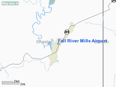
| Fall River Mills Airport |
| IATA: none – ICAO: none – FAA LID: O89 |
| Summary |
| Airport type |
Public |
| Location |
Fall River Mills, California |
| Elevation AMSL |
3,323 ft / 1,013 m |
| Coordinates |
41°01′07.587″N 121°25′59.929″W / 41.01877417°N 121.43331361°W / 41.01877417; -121.43331361Coordinates: 41°01′07.587″N 121°25′59.929″W / 41.01877417°N 121.43331361°W / 41.01877417; -121.43331361 |
| Runways |
| Direction |
Length |
Surface |
| ft |
m |
| 2/20 |
3,600 |
1,097 |
Asphalt |
Fall River Mills Airport (FAA LID: O89) is a public airport located one mile (1.6 km) north of Fall River Mills, serving Shasta County, California, USA. The airport has one runway and is mostly used for general aviation.
Facilities
Bryon Airport has one runway:
- Runway 2/20: 3,600 x 75 ft (1,097 x 23 m). Surface: Asphalt
The above content comes from Wikipedia and is published under free licenses – click here to read more.
Location
& QuickFacts
|
FAA
Information Effective: |
2006-06-08 |
|
Airport
Identifier: |
O89 |
|
Longitude/Latitude: |
121-25-59.9290W/41-01-07.5870N
-121.433314/41.018774 (Estimated) |
|
Elevation: |
3323 ft / 1012.85 m (Estimated) |
|
Land: |
233 acres |
|
From
nearest city: |
1 nautical miles N of Fall River Mills, CA |
|
Location: |
Shasta County, CA |
|
Magnetic Variation: |
17E (1985) |
Owner
& Manager
|
Ownership: |
Publicly owned |
|
Owner: |
County Of Shasta |
|
Address: |
1855 Placer St
Redding, CA 96001 |
|
Phone
number: |
530-225-5661 |
|
Manager: |
Daniel J. Kovacich |
|
Address: |
, 1855 Placer Street
Redding, CA 96001 |
|
Phone
number: |
530-225-5155
ARPT PAY PHONE 530-336-9948. |
Airport
Operations and Facilities
|
Airport
Use: |
Open to public |
|
Wind
indicator: |
Yes |
|
Segmented
Circle: |
Yes |
|
Control
Tower: |
No |
|
Attendance
Schedule: |
UNATNND |
|
Lighting
Schedule: |
DUSK-DAWN
ACTVT LIRL RY 02/20 - CTAF. |
|
Beacon
Color: |
Clear-Green (lighted land airport) |
|
Landing
fee charge: |
No |
|
Sectional
chart: |
Klamath Falls |
|
Region: |
AWP - Western-Pacific |
|
Traffic
Pattern Alt: |
800 ft |
|
Boundary
ARTCC: |
ZOA - Oakland |
|
Tie-in
FSS: |
RIU - Rancho Murieta |
|
FSS
on Airport: |
No |
|
FSS
Phone: |
916-354-0161 |
|
FSS
Toll Free: |
1-800-WX-BRIEF |
|
NOTAMs
Facility: |
RIU (NOTAM-d service avaliable) |
|
Federal Agreements: |
N1 |
Airport
Communications
|
CTAF: |
122.800 |
|
Unicom: |
122.800 |
Airport
Services
|
Fuel
available: |
100LL |
|
Airframe
Repair: |
MAJOR |
|
Power
Plant Repair: |
MAJOR |
|
Bottled
Oxygen: |
NONE |
|
Bulk
Oxygen: |
NONE |
|
Runway Information
Runway 02/20
|
Dimension: |
3600 x 75 ft / 1097.3 x 22.9 m |
|
Surface: |
ASPH, Good Condition |
|
Edge
Lights: |
Low |
|
|
Runway 02 |
Runway 20 |
|
Traffic
Pattern: |
Left |
Left |
|
Markings: |
Basic, Fair Condition |
Basic, Fair Condition |
|
Runway
End Identifier: |
No |
No |
|
Centerline
Lights: |
No |
No |
|
Touchdown
Lights: |
No |
No |
|
Obstruction: |
15 ft road, 650.0 ft from runway, 30:1 slope
to clear |
40 ft trees, 1800.0 ft from runway, 175 ft
right of centerline, 40:1 slope to clear |
|
Radio Navigation
Aids
|
ID |
Type |
Name |
Ch |
Freq |
Var |
Dist |
|
ARU |
NDB |
Alturas |
|
215.00 |
18E |
48.1 nm |
|
RDD |
VOR/DME |
Redding |
021X |
108.40 |
18E |
49.8 nm |
Remarks
- CROP
DUSTERS WORKING INVOF ARPT FEB-OCT.
- UNLIMITED
ROAD ACCESS TO TAXIWAYS, RUNWAY, AND RAMP.
- ARPT
CLSD PERIODICALLY WINTER MONTHS DUE TO SNOW, CALL AMGR (530) 225-5661
FOR CURRENT CONDITIONS.
- PERIODS
OF CONSTRUCTION WITH MEN AND EQUIPMENT SPRING 2006 THRU 2007.
- ACFT
HANGARS AT MIDFIELD LCT 25 FT FM EDGE OF TWY.
- ESTABD
PRIOR TO 15 MAY 1959.
Based Aircraft
|
Aircraft
based on field: |
12 |
|
Single
Engine Airplanes: |
12 |
Operational Statistics
|
Aircraft
Operations: |
116/Week |
|
General
Aviation Local: |
50.0% |
|
General
Aviation Itinerant: |
50.0% |
Fall River Mills Airport
Address:
Shasta County, CA
Tel:
530-225-5661,
530-225-5155
Images
and information placed above are from
http://www.airport-data.com/airport/O89/
We
thank them for the data!
| General
Info |
| Country |
United
States |
| State |
CALIFORNIA
|
| FAA ID |
O89
|
| Latitude |
41-01-07.587N
|
| Longitude |
121-25-59.929W
|
| Elevation |
3323 feet
|
| Near City |
FALL RIVER
MILLS |
We don't guarantee the information is fresh and accurate. The data may
be wrong or outdated.
For more up-to-date information please refer to other sources.
|
|


