 |
|
| Delano Municipal Airport |
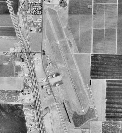 |
| USGS aerial photo as of 4 September 1994 |
| IATA: none – ICAO: KDLO – FAA LID: DLO |
| Summary |
| Airport type |
Public |
| Owner |
City of Delano |
| Serves |
Delano, California |
| Elevation AMSL |
314 ft / 96 m |
| Coordinates |
35°44′44″N 119°14′11″W / 35.74556°N 119.23639°W / 35.74556; -119.23639 |
| Runways |
| Direction |
Length |
Surface |
| ft |
m |
| 14/32 |
5,651 |
1,722 |
Asphalt |
| Statistics (2006) |
| Aircraft operations |
19,000 |
| Based aircraft |
44 |
| Source: Federal Aviation Administration |
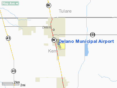
Delano Municipal Airport (ICAO: KDLO, FAA LID: DLO) is a public airport located two miles (3 km) southeast of the central business district of Delano, a city in Kern County, California, United States. It is owned by the City of Delano.
Although most U.S. airports use the same three-letter location identifier for the FAA and IATA, Delano Municipal Airport is assigned DLO by the FAA but has no designation from the IATA. Facilities and aircraft
Delano Municipal Airport covers an area of 546 acres (221 ha) which contains one asphalt paved runway (14/32) measuring 5,651 x 75 ft (1,722 x 23 m).
For the 12-month period ending January 23, 2006, the airport had 19,000 aircraft operations, an average of 52 per day, all of which were general aviation. There are 44 aircraft based at this airport: 68% single engine, 5% multi-engine and 27% helicopters.
History
The airfield was opened in April 1940. During World War II the airfield was known as Delano Army Airfield and was used by the United States Army Air Forces Air Technical Service Command. With the end of the war, the base was declared excess to requirements and returned to civil control.
The above content comes from Wikipedia and is published under free licenses – click here to read more.
Location
& QuickFacts
|
FAA
Information Effective: |
2006-06-08 |
|
Airport
Identifier: |
DLO |
|
Longitude/Latitude: |
119-14-11.4140W/35-44-44.0900N
-119.236504/35.745581 (Estimated) |
|
Elevation: |
314
ft / 95.71 m (Surveyed) |
|
Land: |
546
acres |
|
From
nearest city: |
2 nautical miles SE of Delano, CA |
|
Location: |
Kern County, CA |
|
Magnetic Variation: |
16E (1965) |
Owner
& Manager
|
Ownership: |
Publicly owned |
|
Owner: |
City Of Delano |
|
Address: |
1015 11th Ave.
Delano, CA 93215 |
|
Phone
number: |
661-720-2228 |
|
Manager: |
Phil Newhouse
COMMUNITY SERVICES DIRECTOR. |
|
Address: |
P.o. Box 939
Delano, CA 93216 |
|
Phone number: |
661-721-3335 |
Airport
Operations and Facilities
|
Airport
Use: |
Open to public |
|
Wind
indicator: |
Yes |
|
Segmented
Circle: |
Yes |
|
Control
Tower: |
No |
|
Attendance
Schedule: |
ALL/ALL/0800-1700 |
|
Lighting
Schedule: |
DUSK-DAWN
MIRL RY 14/32 PRESET LOW INTST DUSK-DAWN; TO INCR INTST
ACTVT - CTAF. |
|
Beacon
Color: |
Clear-Green (lighted land airport) |
|
Landing
fee charge: |
No |
|
Sectional
chart: |
Los Angeles |
|
Region: |
AWP - Western-Pacific |
|
Traffic
Pattern Alt: |
800
ft |
|
Boundary
ARTCC: |
ZLA - Los Angeles |
|
Tie-in
FSS: |
RIU - Rancho Murieta |
|
FSS
on Airport: |
No |
|
FSS
Phone: |
916-354-0161 |
|
FSS
Toll Free: |
1-800-WX-BRIEF |
|
NOTAMs
Facility: |
RIU (NOTAM-d service avaliable) |
|
Federal Agreements: |
NGRY |
Airport
Communications
|
CTAF: |
122.800 |
|
Unicom: |
122.800 |
Airport
Services
|
Fuel
available: |
100LL |
|
Airframe
Repair: |
MINOR |
|
Power
Plant Repair: |
MAJOR |
|
Bottled
Oxygen: |
NONE |
|
Bulk
Oxygen: |
NONE |
|
Runway Information
Runway 14/32
|
Dimension: |
5651 x 75 ft / 1722.4 x 22.9 m |
|
Surface: |
ASPH, Good Condition |
|
Weight
Limit: |
Single wheel: 30000 lbs. |
|
Edge
Lights: |
Medium |
|
|
Runway 14 |
Runway 32 |
|
Longitude: |
119-14-23.9580W |
119-13-58.8820W |
|
Latitude: |
35-45-10.0990N |
35-44-18.0810N |
|
Elevation: |
314.00
ft |
311.00
ft |
|
Alignment: |
127 |
127 |
|
Traffic
Pattern: |
Right |
Left |
|
Markings: |
Non-precision instrument, Good Condition |
Non-precision instrument, Good Condition |
|
Displaced
threshold: |
1640.00
ft |
0.00 ft |
|
VASI: |
2-light PAPI on left side |
2-light PAPI on left side |
|
Visual
Glide Angle: |
3.50� |
3.00� |
|
Runway
End Identifier: |
Yes |
Yes |
|
Centerline
Lights: |
No |
No |
|
Touchdown
Lights: |
No |
No |
|
Obstruction: |
15 ft road, 200.0 ft from runway, 130 ft right
of centerline
APCH RATIO 50:1 TO DSPLCD THR.
ROAD +6 FT FENCE THRU WEST SIDE OF PRIM SURF. |
, 50:1 slope to clear |
|
Radio Navigation
Aids
|
ID |
Type |
Name |
Ch |
Freq |
Var |
Dist |
|
COR |
NDB |
Salyer Farms |
|
205.00 |
16E |
24.2 nm |
|
TTE |
VOR/DME |
Tule |
029X |
109.20 |
16E |
14.6 nm |
|
VIS |
VOR/DME |
Visalia |
031X |
109.40 |
16E |
39.2 nm |
|
EHF |
VORTAC |
Shafter |
101X |
115.40 |
14E |
17.1 nm |
|
AVE |
VORTAC |
Avenal |
118X |
117.10 |
16E |
36.7 nm |
|
FLW |
VORTAC |
Fellows |
122X |
117.50 |
16E |
49.9 nm |
|
BFL |
VOT |
Bakersfield |
|
111.20 |
|
21.4 nm |
Remarks
- SEASONAL
CROP DUSTER OPNS ON ARPT EAST OF RY 14/32.
- AFTER
HRS EMERGENCY CTC POLICE DEPT (661) 721-3377.
Based Aircraft
|
Aircraft
based on field: |
44 |
|
Single
Engine Airplanes: |
30 |
|
Multi
Engine Airplanes: |
2 |
|
Helicopters: |
12 |
Operational Statistics
|
Aircraft
Operations: |
53/Day |
|
General
Aviation Local: |
42.1% |
|
General
Aviation Itinerant: |
57.9% |
Delano Municipal Airport
Address:
Kern County, CA
Tel:
661-720-2228,
661-721-3335
Images
and information placed above are from
http://www.airport-data.com/airport/DLO/
We
thank them for the data!
| General
Info |
| Country |
United
States |
| State |
CALIFORNIA
|
| FAA ID |
DLO
|
| Latitude |
35-44-44.090N
|
| Longitude |
119-14-11.414W
|
| Elevation |
314 feet
|
| Near City |
DELANO
|
We don't guarantee the information is fresh and accurate. The data may
be wrong or outdated.
For more up-to-date information please refer to other sources.
|
|


