 |
|
Corning Municipal Airport |
| Corning Municipal Airport |
| IATA: none – ICAO: none – FAA LID: 0O4 |
| Summary |
| Airport type |
City of Corning |
| Operator |
Corning, California |
| Location |
292 |
| Elevation AMSL |
89 ft / m |
| Coordinates |
39°56′37″N 122°10′16″W / 39.94361°N 122.17111°W / 39.94361; -122.17111Coordinates: 39°56′37″N 122°10′16″W / 39.94361°N 122.17111°W / 39.94361; -122.17111 |
| Runways |
| Direction |
Length |
Surface |
| ft |
m |
| 16/34 |
2,702 |
824 |
Asphalt |
Corning Municipal Airport (FAA LID: 0O4) is a public airport located one mile (1.6 km) northeast of Corning, serving Tehama County, California, USA. The airport is mostly used for general aviation.
Facilities
Corning Municipal Airport covers 77 acres and has one runway:
- Runway 16/34: 2,702 x 50 ft (824 x 15 m), Surface: Asphalt
The above content comes from Wikipedia and is published under free licenses – click here to read more.
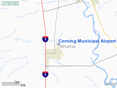
Location
& QuickFacts
|
FAA
Information Effective: |
2006-06-08 |
|
Airport
Identifier: |
0O4 |
|
Longitude/Latitude: |
122-10-16.1000W/39-56-37.1000N
-122.171139/39.943639 (Estimated) |
|
Elevation: |
292
ft / 89.00 m (Estimated) |
|
Land: |
77
acres |
|
From
nearest city: |
1 nautical miles NE of Corning, CA |
|
Location: |
Tehama County, CA |
|
Magnetic Variation: |
17E (1985) |
Owner
& Manager
|
Ownership: |
Publicly owned |
|
Owner: |
City Of Corning |
|
Address: |
794 3rd Street
Corning, CA 96021 |
|
Phone number: |
916-824-7029 |
|
Manager: |
Stephen Kimbrought |
|
Address: |
794 3rd Street
Corning, CA 96021 |
|
Phone number: |
916-824-7029 |
Airport
Operations and Facilities
|
Airport
Use: |
Open to public |
|
Wind
indicator: |
Yes |
|
Segmented
Circle: |
Yes |
|
Control
Tower: |
No |
|
Attendance
Schedule: |
ALL/ALL/0800-1700
FBO ON ARPT PHONE 916-824-0644. |
|
Lighting
Schedule: |
DUSK-DAWN
ACTVT MIRL RY 16/34 - CTAF. |
|
Beacon
Color: |
Clear-Green (lighted land airport) |
|
Landing
fee charge: |
No |
|
Sectional
chart: |
San Francisco |
|
Region: |
AWP - Western-Pacific |
|
Traffic
Pattern Alt: |
1000
ft |
|
Boundary
ARTCC: |
ZOA - Oakland |
|
Tie-in
FSS: |
RIU - Rancho Murieta |
|
FSS
on Airport: |
No |
|
FSS
Phone: |
916-354-0161 |
|
FSS
Toll Free: |
1-800-WX-BRIEF |
|
NOTAMs
Facility: |
RIU (NOTAM-d service avaliable) |
|
Federal Agreements: |
NGY |
Airport
Communications
|
CTAF: |
123.000 |
|
Unicom: |
123.000 |
Airport
Services
|
Fuel
available: |
100LL |
|
Airframe
Repair: |
MAJOR |
|
Power
Plant Repair: |
MAJOR |
|
Runway Information
Runway 16/34
|
Dimension: |
2702
x 50 ft / 823.6 x 15.2 m
300 FT STOPWAY NORTH END OF RY; 200 FT STOPWAY SOUTH END OF RY. |
|
Surface: |
ASPH, Good Condition |
|
Weight
Limit: |
Single wheel: 12000 lbs. |
|
Edge
Lights: |
Medium |
|
|
Runway 16 |
Runway 34 |
|
Longitude: |
122-10-16.0833W |
122-10-16.0697W |
|
Latitude: |
39-56-50.4501N |
39-56-23.7460N |
|
Elevation: |
293.00
ft |
293.00
ft |
|
Alignment: |
127 |
127 |
|
Traffic
Pattern: |
Left |
Right |
|
Markings: |
Basic, Good Condition |
, |
|
Obstruction: |
40 ft tree, 1100.0 ft from runway, 22:1 slope
to clear |
55 ft poles, 1900.0 ft from runway, 250 ft
left of centerline, 30:1 slope to clear |
|
Radio Navigation
Aids
|
ID |
Type |
Name |
Ch |
Freq |
Var |
Dist |
|
PBT |
NDB |
Proberta |
|
338.00 |
16E |
10.7 nm |
|
OVE |
NDB |
Oroville |
|
212.00 |
16E |
37.0 nm |
|
CIC |
VOR/DME |
Chico |
035X |
109.80 |
16E |
17.6 nm |
|
RDD |
VOR/DME |
Redding |
021X |
108.40 |
18E |
34.2 nm |
|
RBL |
VORTAC |
Red Bluff |
104X |
115.70 |
18E |
9.8 nm |
|
MXW |
VORTAC |
Maxwell |
037X |
110.00 |
18E |
37.7 nm |
Remarks
- ULTRALIGHT
ACTIVITY ON & INVOF ARPT.
Based Aircraft
|
Aircraft
based on field: |
25 |
|
Single
Engine Airplanes: |
18 |
|
Multi
Engine Airplanes: |
1 |
|
Ultralights: |
6 |
Operational Statistics
|
Aircraft
Operations: |
168/Week |
|
Air Taxi: |
0.6% |
|
General
Aviation Local: |
64.4% |
|
General
Aviation Itinerant: |
35.0% |
Corning Municipal Airport
Address:
Tehama County, CA
Tel:
916-824-7029
Images
and information placed above are from
http://www.airport-data.com/airport/0O4/
We
thank them for the data!
| General
Info |
| Country |
United
States |
| State |
CALIFORNIA
|
| FAA ID |
0O4
|
| Latitude |
39-56-37.565N
|
| Longitude |
122-10-16.961W
|
| Elevation |
292 feet
|
| Near City |
CORNING
|
We don't guarantee the information is fresh and accurate. The data may
be wrong or outdated.
For more up-to-date information please refer to other sources.
|
|


