|
|
| Columbia Airport |
 |
| IATA: COA – ICAO: none – FAA LID: O22 |
| Summary |
| Airport type |
Public |
| Owner |
County of Tuolumne |
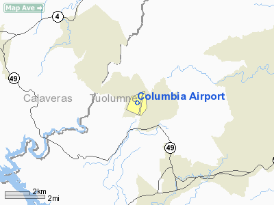
| Location |
Columbia, California |
| Elevation AMSL |
2,118 ft / 646 m |
| Coordinates |
38°01′50″N 120°24′52″W / 38.03056°N 120.41444°W / 38.03056; -120.41444 |
| Runways |
| Direction |
Length |
Surface |
| ft |
m |
| 11/29 |
2,600 |
792 |
Turf |
| 17/35 |
4,670 |
1,423 |
Asphalt |
| Statistics (2001) |
| Aircraft operations |
46,020 |
| Based aircraft |
243 |
| Source: Federal Aviation Administration |
Columbia Airport (IATA: COA, FAA LID: O22) is a public airport located one mile (1.6 km) southwest of the central business district of Columbia, in Tuolumne County, California, United States. It is owned by the County of Tuolumne.
Facilities and aircraft
Columbia Airport covers an area of 356 acres (144 ha) which contains two runways: 17/35 is asphalt paved and measures 4,670 x 75 ft (1,423 x 23 m), and turf runway 11/29 measuring 2,600 x 100 ft (792 x 30 m).
For the 12-month period ending December 31, 2001, the airport had 46,020 aircraft operations, an average of 126 per day: 96% general aviation, 4% air taxi and <1% military. There are 243 aircraft based at this airport: 95% single engine, 2% multi-engine, 2% helicopters and 1% ultralight.
The above content comes from Wikipedia and is published under free licenses – click here to read more.
Location
& QuickFacts
|
FAA
Information Effective: |
2006-06-08 |
|
Airport Identifier: |
O22 |
|
Longitude/Latitude: |
120-24-52.4000W/38-01-49.5230N
-120.414556/38.030423 (Estimated) |
|
Elevation: |
2118
ft / 645.57 m (Surveyed) |
|
Land: |
356
acres |
|
From nearest
city: |
1
nautical miles SW of Columbia, CA |
|
Location: |
Tuolumne County, CA |
|
Magnetic
Variation: |
16E
(1985) |
Owner
& Manager
|
Ownership: |
Publicly
owned |
|
Owner: |
County
Of Tuolumne |
|
Address: |
2
South Green St.
Sonora, CA 95370 |
|
Phone
number: |
209-533-5685 |
|
Manager: |
Jim
Thomas |
|
Address: |
10723 Airport Rd
Columbia, CA 95310 |
|
Phone
number: |
209-533-5685 |
Airport
Operations and Facilities
|
Airport
Use: |
Open to
public |
|
Wind indicator: |
Yes |
|
Segmented
Circle: |
Yes |
|
Control Tower: |
No |
|
Attendance
Schedule: |
ALL/ALL/0800-1700 |
|
Lighting
Schedule: |
DUSK-DAWN
ACTVT MIRL RY 17/35 & REIL RYS 17 & 35 - CTAF. |
|
Beacon Color: |
Clear-Green (lighted land airport)
ARPT HAS TWO ROTG BCNS; ONE ON THE ARPT AND ONE 6500' SE
THR RWY 35. |
|
Landing fee
charge: |
Yes |
|
Sectional
chart: |
San
Francisco |
|
Region: |
AWP
- Western-Pacific |
|
Traffic Pattern
Alt: |
1000
ft |
|
Boundary
ARTCC: |
ZOA
- Oakland |
|
Tie-in FSS: |
RIU
- Rancho Murieta |
|
FSS on Airport: |
No |
|
FSS Phone: |
916-354-0161 |
|
FSS Toll
Free: |
1-800-WX-BRIEF |
|
NOTAMs Facility: |
RIU
(NOTAM-d service avaliable) |
|
Federal
Agreements: |
NGY |
Airport
Communications
|
CTAF: |
122.975 |
|
Unicom: |
122.975
|
Airport
Services
|
Fuel
available: |
100LLA |
|
Airframe
Repair: |
MAJOR |
|
Power
Plant Repair: |
MAJOR |
|
Bottled Oxygen: |
LOW |
|
Bulk Oxygen: |
LOW |
|
Runway Information
Runway 11/29
|
Dimension: |
2600
x 100 ft / 792.5 x 30.5 m
RY END SAFETY AREAS NSTD LENGTH; RY 17 210 FT; RY 35 300 FT. |
|
Surface: |
TURF,
Good Condition |
|
|
Runway
11 |
Runway
29 |
|
Longitude: |
120-25-13.8500W |
120-24-50.3410W |
|
Latitude: |
38-01-58.8820N |
38-01-41.1430N |
|
Elevation: |
2089.00 ft |
2077.00 ft |
|
Alignment: |
127 |
127 |
|
Traffic Pattern: |
Right |
Left |
|
Markings: |
None, |
Numbers only, Good Condition |
|
Runway End
Identifier: |
No |
No |
|
Centerline
Lights: |
No |
No |
|
Touchdown Lights: |
No |
No |
|
Obstruction: |
135
ft trees, 2190.0 ft from runway, 125 ft left of centerline,
16:1 slope to clear |
115
ft trees, 1600.0 ft from runway, 100 ft right of centerline,
13:1 slope to clear |
|
Runway 17/35
|
Dimension: |
4670
x 75 ft / 1423.4 x 22.9 m
RY END SAFETY AREAS NSTD LENGTH; RY 17 210 FT; RY 35 300 FT. |
|
Surface: |
ASPH,
Good Condition |
|
Weight Limit: |
Single wheel: 30000 lbs. |
|
Edge Lights: |
Medium |
|
|
Runway
17 |
Runway
35 |
|
Longitude: |
120-24-41.8410W |
120-24-52.1440W |
|
Latitude: |
38-02-11.9980N |
38-01-26.5610N |
|
Elevation: |
2118.00 ft |
2071.00 ft |
|
Alignment: |
127 |
10 |
|
Traffic Pattern: |
Right |
Left |
|
Markings: |
Non-precision instrument, Fair Condition |
Non-precision instrument, Fair Condition |
|
Crossing Height: |
55.00 ft |
35.00 ft |
|
Displaced threshold: |
595.00 ft |
589.00 ft |
|
VASI: |
2-box on left side |
2-box on left side |
|
Visual Glide
Angle: |
4.55� |
4.00� |
|
Runway End
Identifier: |
Yes
& RY 35 REILS OTS INDEFLY. |
Yes |
|
Centerline
Lights: |
No |
No |
|
Touchdown Lights: |
No |
No |
|
Obstruction: |
33
ft gnd, 450.0 ft from runway, 125 ft right of centerline,
8:1 slope to clear
APCH RATIO FM DSPLCD THLD 31:1. |
61
ft trees, 1700.0 ft from runway, 350 ft right of centerline,
24:1 slope to clear
APCH RATIO FM DSPLCD THLD 37:1. |
|
Radio Navigation
Aids
|
ID |
Type |
Name |
Ch |
Freq |
Var |
Dist |
|
MOD |
VOR/DME |
Modesto |
093X |
114.60 |
17E |
35.4
nm |
|
HNW |
VOR/DME |
Hangtown |
102X |
115.50 |
17E |
44.6
nm |
|
HYP |
VOR/DME |
El
Nido |
089X |
114.20 |
15E |
48.8
nm |
|
LIN |
VORTAC |
Linden |
095X |
114.80 |
17E |
28.0
nm |
|
ECA |
VORTAC |
Manteca |
107X |
116.00 |
17E |
37.8
nm |
Remarks
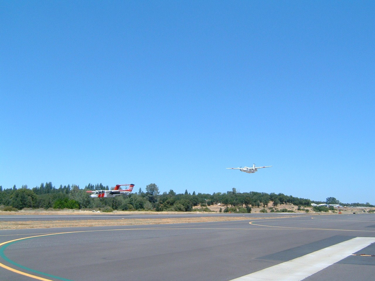
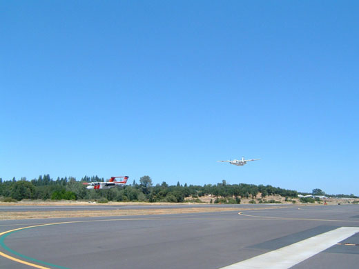
- FORESTRY
AIR TANKER OPERS FM ARPT DURING SUMMER FIRE SEASON.
- LANDING
FEE FOR ALL COMMERCIAL OPERATORS REGARDLESS OF SIZE & CORPORATE
ACFT OVER 12500 LBS GROSS LANDING WEIGHT.
- AVOID
FLIGHTS OVER COLUMBIA STATE PARK NE OF ARPT.
- HELICOPTER
PARKING AREA 300 FT BY 120 FT (3 POSITIONS).
- VARYING
WIND DIRECTION & VELOCITY MAY BE ENCOUNTERED AT MID POINT OF RY
17/35 DUE TO TERRAIN FEATURES & WIND FLOW PATTERNS.
- ULTRALIGHT
ACTIVITY ON ARPT; SOUTHWEST TFC PAT ALT 500' BLO STANDARD ARPT TFC PAT
TO RWY 29; ULTRALIGHTS TO OPERATE WEST OF RWY 35.
- CTN:
DEER ON & INVOF ARPT.
- RY
11 DEPS PROHIBITED DUE TO CONFLICT WITH MAIN RY.
- DIRT
TWY NORTH SIDE OF RY 11/29 NOT RECOMMENDED FOR USE NOV-MAR.
- RY
29 NOT RECOMMENDED FOR USE DURING WINTER MONTHS NOV THROUGH MAR.
- ALL
JET & HIGH PERFORMANCE ACFT EQUIPPED WITH 250 HORSEPOWER ENGINES
& MORE ARE REQUESTED TO LAND RY 35 & DEPART RY 17 WIND &
WEATHER PERMITTING.
Based Aircraft
|
Aircraft
based on field: |
243 |
|
Single Engine Airplanes: |
230 |
|
Multi Engine Airplanes: |
5 |
|
Helicopters: |
5 |
|
Ultralights: |
3 |
Operational
Statistics
|
Aircraft
Operations: |
127/Day |
|
Air Taxi: |
4.3% |
|
General Aviation
Local: |
47.8% |
|
General Aviation
Itinerant: |
47.8% |
|
Military: |
0.0% |
Columbia Airport
Address:
Tuolumne County, CA
Tel:
209-533-5685
Images
and information placed above are from
http://www.airport-data.com/airport/O22/
We
thank them for the data!
| General
Info |
| Country |
United
States |
| State |
CALIFORNIA
|
| FAA ID |
O22
|
| Latitude |
38.030422
38� 01' 49.52" N |
| Longitude |
-120.414556
120� 24' 52.40" W |
| Elevation |
2118 feet
646 meters |
| Magnetic
Variation |
014� E
(01/06) |
| Beacon |
Yes
|
| Operating
Agency |
U.S.CIVIL
AIRPORT WHEREIN PERMIT COVERS USE BY TRANSIT MILITARY AIRCRAFT
|
| Daylight
Savings Time |
First
Sunday in April at 0200 to last Sunday in October at 0200 local time
(Exception Arizona and that portion of Indiana in the Eastern Time
Zone) |
We don't guarantee the information is fresh and accurate. The data may
be wrong or outdated.
For more up-to-date information please refer to other sources.
|
|