 |
|
Cloverdale Municipal Airport |
| Cloverdale Municipal Airport |
 |
| IATA: none – ICAO: none – FAA LID: O60 |
| Summary |
| Airport type |
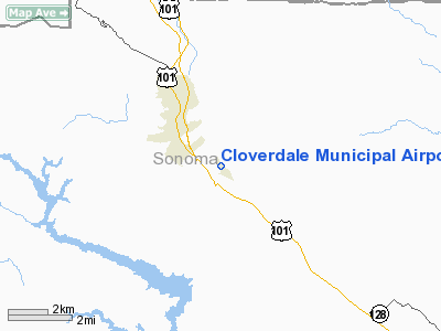
City of Cloverdale |
| Operator |
Cloverdale, California |
| Location |
272 |
| Elevation AMSL |
82.9 ft / m |
| Coordinates |
38°46′34″N 122°59′33″W / 38.77611°N 122.9925°W / 38.77611; -122.9925Coordinates: 38°46′34″N 122°59′33″W / 38.77611°N 122.9925°W / 38.77611; -122.9925 |
| Runways |
| Direction |
Length |
Surface |
| ft |
m |
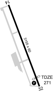
| 14/32 |
3,155 |
962 |
Asphalt |
Cloverdale Municipal Airport (FAA LID: O60) is a public airport located three miles (4.8 km) southeast of Cloverdale, serving Sonoma County, California, USA. The airport is mostly used for general aviation. There are additional activities on the airport: Skydiving, ultralight and experimental activities; it is home to Quality Sport Planes, the western representative for Zenith Aircraft Company since 2005.
Facilities
Cloverdale Municipal Airport covers 58 acres (230,000 m) and has one runway:
- Runway 14/32: 3,155 x 60 ft (962 x 18 m), Surface: Asphalt
The above content comes from Wikipedia and is published under free licenses – click here to read more.
Location
& QuickFacts
|
FAA
Information Effective: |
2006-06-08 |
|
Airport
Identifier: |
O60 |
|
Longitude/Latitude: |
122-59-33.4990W/38-46-33.6700N
-122.992639/38.776019 (Estimated) |
|
Elevation: |
272
ft / 82.91 m (Estimated) |
|
Land: |
58
acres |
|
From
nearest city: |
3 nautical miles SE of Cloverdale, CA |
|
Location: |
Sonoma County, CA |
|
Magnetic Variation: |
16E (1985) |
Owner
& Manager
|
Ownership: |
Publicly owned |
|
Owner: |
City Of Cloverdale |
|
Address: |
Po Box 217
Cloverdale, CA 95425 |
|
Phone
number: |
707-894-2521 |
|
Manager: |
Bob Crabb |
|
Address: |
P.o. Box 217
Cloverdale, CA 95425 |
|
Phone number: |
707-894-1791 |
Airport
Operations and Facilities
|
Airport
Use: |
Open to public |
|
Wind
indicator: |
Yes |
|
Segmented
Circle: |
Yes |
|
Control
Tower: |
No |
|
Attendance
Schedule: |
ALL/ALL/0800-1700 |
|
Lighting
Schedule: |
RDO-CTL
ACTVT MIRL RY 14/32 AND PAPI RY 32 - CTAF. |
|
Landing
fee charge: |
No |
|
Sectional
chart: |
San Francisco |
|
Region: |
AWP - Western-Pacific |
|
Traffic
Pattern Alt: |
1000
ft |
|
Boundary
ARTCC: |
ZOA - Oakland |
|
Tie-in
FSS: |
OAK - Oakland |
|
FSS
on Airport: |
No |
|
FSS
Phone: |
510-273-6111 |
|
FSS
Toll Free: |
1-800-WX-BRIEF |
|
NOTAMs
Facility: |
OAK (NOTAM-d service avaliable) |
|
Federal Agreements: |
NGY |
Airport
Communications
|
CTAF: |
122.800 |
|
Unicom: |
122.800 |
Airport
Services
|
Fuel
available: |
100LL |
|
Bottled
Oxygen: |
NONE |
|
Bulk
Oxygen: |
NONE |
|
Runway Information
Runway 14/32
|
Dimension: |
3155 x 60 ft / 961.6 x 18.3 m |
|
Surface: |
ASPH, Good Condition |
|
Weight
Limit: |
Single wheel: 12000 lbs. |
|
Edge
Lights: |
Medium |
|
|
Runway 14 |
Runway 32 |
|
Longitude: |
122-59-41.9990W |
122-59-24.9990W |
|
Latitude: |
38-46-47.6690N |
38-46-19.6700N |
|
Elevation: |
272.00
ft |
269.00
ft |
|
Traffic
Pattern: |
Left |
Right |
|
Markings: |
Basic, Fair Condition |
Basic, Fair Condition |
|
Crossing
Height: |
0.00 ft |
15.00 ft |
|
Displaced
threshold: |
0.00 ft |
510.00
ft |
|
VASI: |
|
2-light PAPI on left side |
|
Visual
Glide Angle: |
0.00� |
3.50� |
|
Runway
End Identifier: |
No |
No |
|
Centerline
Lights: |
No |
No |
|
Touchdown
Lights: |
No |
No |
|
Obstruction: |
, 50:1 slope to clear |
15 ft brush, 200.0 ft from runway
RWY 32 APCH RATIO 38:1 TO DSPLCD THLD; 27:1 OVER 75 FT POLE
AT 1520 FT, 300 L FM END OF RWY.
RWY 32 +10 FT ROAD AT 0 FT & 105 FT L; +4 FT FENCE AT
0 FT & 125 FT L; +20 FT BRUSH AT 200 FT & 100 FT R. |
|
Radio Navigation
Aids
|
ID |
Type |
Name |
Ch |
Freq |
Var |
Dist |
|
LOP |
NDB |
Lampson |
|
217.00 |
16E |
14.1 nm |
|
STS |
VOR/DME |
Santa Rosa |
077X |
113.00 |
16E |
18.2 nm |
|
ENI |
VORTAC |
Mendocino |
070X |
112.30 |
16E |
21.2 nm |
|
PYE |
VORTAC |
Point Reyes |
084X |
113.70 |
17E |
42.3 nm |
|
SGD |
VORTAC |
Scaggs Island |
058X |
112.10 |
17E |
46.2 nm |
|
ILA |
VORTAC |
Williams |
091X |
114.40 |
18E |
48.5 nm |
|
MXW |
VORTAC |
Maxwell |
037X |
110.00 |
18E |
48.5 nm |
Based Aircraft
|
Aircraft
based on field: |
21 |
|
Single
Engine Airplanes: |
18 |
|
Multi
Engine Airplanes: |
3 |
Operational Statistics
|
Aircraft
Operations: |
210/Week |
|
General
Aviation Local: |
27.5% |
|
General
Aviation Itinerant: |
72.5% |
Cloverdale Municipal Airport
Address:
Sonoma County, CA
Tel:
707-894-2521,
707-894-1791
Images
and information placed above are from
http://www.airport-data.com/airport/O60/
We
thank them for the data!
| General
Info |
| Country |
United
States |
| State |
CALIFORNIA
|
| FAA ID |
O60
|
| Latitude |
38-46-33.670N
|
| Longitude |
122-59-33.499W
|
| Elevation |
272 feet
|
| Near City |
CLOVERDALE
|
We don't guarantee the information is fresh and accurate. The data may
be wrong or outdated.
For more up-to-date information please refer to other sources.
|
|


