 |
|
| Chowchilla Airport |
| IATA: none – ICAO: none – FAA LID: 2O6 |
| Summary |
| Airport type |
City of Chowchilla |
| Operator |
Chowchilla, California |
| Location |
242 |
| Elevation AMSL |
73.8 ft / m |
| Coordinates |
37°06′45″N 120°14′49″W / 37.1125°N 120.24694°W / 37.1125; -120.24694Coordinates: 37°06′45″N 120°14′49″W / 37.1125°N 120.24694°W / 37.1125; -120.24694 |
| Runways |
| Direction |
Length |
Surface |
| ft |
m |
| 12/30 |
3,250 |
991 |
Asphalt |
Chowchilla Airport (FAA LID: 2O6) is a public airport located one mile (1.6 km) southeast of Chowchilla, serving Madera County, California, USA. The airport is mostly used for general aviation.
Facilities
Chowchilla Airport covers 75 acres (300,000 m) and has one runway:
- Runway 12/30: 3,250 x 60 ft (991 x 18 m), Surface: Asphalt
The above content comes from Wikipedia and is published under free licenses – click here to read more.
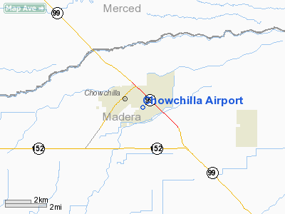
Location
& QuickFacts
|
FAA
Information Effective: |
2006-06-08 |
|
Airport
Identifier: |
2O6 |
|
Longitude/Latitude: |
120-14-48.6260W/37-06-44.7990N
-120.246841/37.112444 (Estimated) |
|
Elevation: |
242 ft / 73.76 m (Estimated) |
|
Land: |
75 acres |
|
From
nearest city: |
1 nautical miles SE of Chowchilla, CA |
|
Location: |
Madera County, CA |
|
Magnetic Variation: |
15E (1985) |
Owner
& Manager
|
Ownership: |
Publicly owned |
|
Owner: |
City Of Chowchilla |
|
Address: |
145 Robertson Blvd
Chowchilla, CA 93610 |
|
Phone number: |
209-665-8615 |
|
Manager: |
Nancy Red |
|
Address: |
145 Robertson Blvd
Chowchilla, CA 93610 |
|
Phone number: |
209-665-8640 |
Airport
Operations and Facilities
|
Airport
Use: |
Open to public |
|
Wind
indicator: |
Yes |
|
Segmented
Circle: |
Yes |
|
Control
Tower: |
No |
|
Attendance
Schedule: |
UNATNDD |
|
Lighting
Schedule: |
RDO-CTL
ACTVT MIRL RY 12/30 - CTAF. |
|
Landing
fee charge: |
No |
|
Sectional
chart: |
San Francisco |
|
Region: |
AWP - Western-Pacific |
|
Traffic
Pattern Alt: |
1000 ft |
|
Boundary
ARTCC: |
ZOA - Oakland |
|
Tie-in
FSS: |
RIU - Rancho Murieta |
|
FSS
on Airport: |
No |
|
FSS
Phone: |
916-354-0161 |
|
FSS
Toll Free: |
1-800-WX-BRIEF |
|
NOTAMs
Facility: |
RIU (NOTAM-d service avaliable) |
|
Federal Agreements: |
NGY |
Airport
Communications
Airport
Services
|
Bottled
Oxygen: |
NONE |
|
Bulk
Oxygen: |
NONE |
|
Runway Information
Runway 12/30
|
Dimension: |
3250
x 60 ft / 990.6 x 18.3 m
300 FT STOPWAYS AT BOTH ENDS OF RY. |
|
Surface: |
ASPH, Good Condition |
|
Weight
Limit: |
Single wheel: 12000 lbs. |
|
Edge
Lights: |
Medium |
|
|
Runway 12 |
Runway 30 |
|
Elevation: |
237.00 ft |
242.00 ft |
|
Traffic
Pattern: |
Left |
Right |
|
Markings: |
Basic, Good Condition |
Basic, Good Condition |
|
Crossing
Height: |
0.00 ft |
20.00 ft |
|
VASI: |
|
2-box on left side
VASI RY 30 OTS INDEFLY. |
|
Visual
Glide Angle: |
0.00� |
3.00� |
|
Runway
End Identifier: |
No |
No |
|
Centerline
Lights: |
No |
No |
|
Touchdown
Lights: |
No |
No |
|
Obstruction: |
60 ft ant, 1500.0 ft from runway, 100 ft right
of centerline, 21:1 slope to clear |
24 ft rr, 750.0 ft from runway, 22:1 slope
to clear |
|
Radio Navigation
Aids
|
ID |
Type |
Name |
Ch |
Freq |
Var |
Dist |
|
FCH |
NDB |
Chandler |
|
344.00 |
15E |
30.7 nm |
|
CUK |
NDB |
Academy |
|
266.00 |
14E |
37.3 nm |
|
NLC |
TACAN |
Lemoore |
080X |
|
16E |
48.1 nm |
|
HYP |
VOR/DME |
El Nido |
089X |
114.20 |
15E |
9.8 nm |
|
MOD |
VOR/DME |
Modesto |
093X |
114.60 |
17E |
46.0 nm |
|
CZQ |
VORTAC |
Clovis |
076X |
112.90 |
15E |
24.8 nm |
|
FRA |
VORTAC |
Friant |
103X |
115.60 |
17E |
31.2 nm |
|
PXN |
VORTAC |
Panoche |
073X |
112.60 |
16E |
35.0 nm |
Remarks
- APCH
TO RWY 12 +35' POWERLINES 1150' FM THR ON EXTNDD RY CNTRLN.
Based Aircraft
|
Aircraft
based on field: |
28 |
|
Single
Engine Airplanes: |
25 |
|
Multi
Engine Airplanes: |
1 |
|
Ultralights: |
2 |
Operational Statistics
|
Aircraft
Operations: |
130/Week |
|
General
Aviation Local: |
70.2% |
|
General
Aviation Itinerant: |
29.8% |
Chowchilla Airport
Address:
Madera County, CA
Tel:
209-665-8615, 209-665-8640
Images
and information placed above are from
http://www.airport-data.com/airport/2O6/
We
thank them for the data!
| General
Info |
| Country |
United
States |
| State |
CALIFORNIA
|
| FAA ID |
2O6
|
| Latitude |
37-06-44.799N
|
| Longitude |
120-14-48.626W
|
| Elevation |
242 feet
|
| Near City |
CHOWCHILLA
|
We don't guarantee the information is fresh and accurate. The data may
be wrong or outdated.
For more up-to-date information please refer to other sources.
|
|


