 |
|
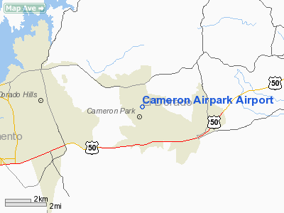
| Cameron Airpark |
| IATA: none – ICAO: none – FAA LID: O61 |
| Summary |
| Airport type |
public use/private owned |
| Owner |
Cameron Park Airport District |
| Location |
Cameron Park, California |
| Elevation AMSL |
1,286 ft / 392 m |
| Coordinates |
38°41′02″N 120°59′15″W / 38.68389°N 120.9875°W / 38.68389; -120.9875Coordinates: 38°41′02″N 120°59′15″W / 38.68389°N 120.9875°W / 38.68389; -120.9875 |
| Runways |
| Direction |
Length |
Surface |
| ft |
m |
| 13/31 |
4,051 |
1,235 |
Asphalt |
Cameron Airpark (FAA LID: O61) is a public airport located in the city of Cameron Park, serving El Dorado County, California, USA. The airport is used for general aviation. The area to the West of the runway is an airpark where home owners can taxi their planes up to their homes. The East side of the runway is public and includes rented tie down spaces, hanger spaces, and a limited number of transient spaces. The runway and general airport area is owned and operated by a council of the home owners on the field. The elevated area to the East of the runway is owned by private individuals. Some of the area is offered for tie down rental spots. Since the airport is privately owned with difference parcels owned by different individuals the airport has continued to shrink as parcels are sold off for non-aviation businesses. The airport has never received federal obligation grant funds and therefor is not obligated to operate.
Facilities
Cameron Airpark covers 61 acres (250,000 m) and has one runway:
- Runway 13/31: 4,051 x 50 ft (1,235 x 15 m), Surface: Asphalt
The above content comes from Wikipedia and is published under free licenses – click here to read more.
Location
& QuickFacts
|
FAA
Information Effective: |
2006-06-08 |
|
Airport
Identifier: |
O61 |
|
Longitude/Latitude: |
120-59-15.1000W/38-41-02.4000N
-120.987528/38.684000 (Estimated) |
|
Elevation: |
1286 ft / 391.97 m (Estimated) |
|
Land: |
61 acres |
|
From
nearest city: |
0 nautical miles N of Cameron Park, CA |
|
Location: |
El Dorado County, CA |
|
Magnetic Variation: |
16E (1985) |
Owner
& Manager
|
Ownership: |
Publicly owned |
|
Owner: |
Cameron Park Arpt District |
|
Address: |
3260 Cameron Park Dr. Rm202
Cameron Park, CA 95682 |
|
Phone
number: |
530-676-8316 |
|
Manager: |
Guy Hooper
ACTING AIRPORT MANAGER |
|
Address: |
3260 Cameron Park Dr. Rm 202
Cameron Park, CA 95682 |
|
Phone number: |
530-676-8316 |
Airport
Operations and Facilities
|
Airport
Use: |
Open to public |
|
Wind
indicator: |
Yes |
|
Segmented
Circle: |
Yes |
|
Control
Tower: |
No |
|
Attendance
Schedule: |
ALL/ALL/0800-1700 |
|
Lighting
Schedule: |
RDO-CTL
ACTVT MIRL RY 13/31 - CTAF. |
|
Landing
fee charge: |
No |
|
Sectional
chart: |
San Francisco |
|
Region: |
AWP - Western-Pacific |
|
Traffic
Pattern Alt: |
1014 ft |
|
Boundary
ARTCC: |
ZOA - Oakland |
|
Tie-in
FSS: |
RIU - Rancho Murieta |
|
FSS
on Airport: |
No |
|
FSS
Phone: |
916-354-0161 |
|
FSS
Toll Free: |
1-800-WX-BRIEF |
|
NOTAMs
Facility: |
RIU (NOTAM-d service avaliable) |
|
Federal Agreements: |
N |
Airport
Communications
|
CTAF: |
123.050 |
|
Unicom: |
123.050 |
Airport
Services
|
Fuel
available: |
100LL |
|
Airframe
Repair: |
MAJOR |
|
Power
Plant Repair: |
MAJOR |
|
Bottled
Oxygen: |
NONE |
|
Bulk
Oxygen: |
NONE |
|
Runway Information
Runway 13/31
|
Dimension: |
4051 x 50 ft / 1234.7 x 15.2 m |
|
Surface: |
ASPH, Good Condition |
|
Edge
Lights: |
Medium |
|
|
Runway 13 |
Runway 31 |
|
Longitude: |
120-59-30.1488W |
120-58-59.9894W |
|
Latitude: |
38-41-18.5051N |
38-40-46.1900N |
|
Elevation: |
1287.00 ft |
1267.00 ft |
|
Alignment: |
127 |
127 |
|
Traffic
Pattern: |
Left |
Left |
|
Markings: |
Basic, Good Condition |
Basic, Good Condition |
|
Crossing
Height: |
0.00 ft |
18.00 ft |
|
Displaced
threshold: |
193.00 ft |
1509.00 ft |
|
VASI: |
|
pulsating/steady burning on left side |
|
Visual
Glide Angle: |
0.00� |
6.00� |
|
Runway
End Identifier: |
No |
No |
|
Centerline
Lights: |
No |
No |
|
Touchdown
Lights: |
No |
No |
|
Obstruction: |
40 ft tree, 410.0 ft from runway, 125 ft left
of centerline, 10:1 slope to clear
+4' TERRAIN 100' RIGHT.
RWY 13 APCH RATIO 5:1 TO DSPLCD THLD OVER 65 FT TREE 350 FT
FROM DSPLCD THRESHOLD.
+65 FT TREE, 150 FT FROM EOR, 125 FT LEFT OF RWY CENTERLINE |
240 ft tree, 2190.0 ft from runway, 300 ft
right of centerline, 9:1 slope to clear
TREE 1190' FROM THR.
RY 31 +60 FT TREE 130 FT LEFT 250 FT FM EOR. APCH RATIO 29:1
TO DSPLCD THLD.
+8
FT GND 200 FT FM EOR. |
|
Radio Navigation
Aids
|
ID |
Type |
Name |
Ch |
Freq |
Var |
Dist |
|
MY |
NDB |
Halow |
|
222.00 |
16E |
41.2 nm |
|
BAB |
TACAN |
Beale |
023X |
|
16E |
34.4 nm |
|
TZZ |
VOR |
Travis |
|
116.40 |
17E |
43.8 nm |
|
HNW |
VOR/DME |
Hangtown |
102X |
115.50 |
17E |
11.4 nm |
|
MCC |
VOR/DME |
Mc Clellan |
029X |
109.20 |
17E |
19.6 nm |
|
MYV |
VOR/DME |
Marysville |
045X |
110.80 |
16E |
37.0 nm |
|
SWR |
VOR/DME |
Squaw Valley |
079X |
113.20 |
16E |
44.9 nm |
|
SAC |
VORTAC |
Sacramento |
099X |
115.20 |
17E |
30.2 nm |
|
LIN |
VORTAC |
Linden |
095X |
114.80 |
17E |
36.6 nm |
|
SAC |
VOT |
Sacramento Executive |
|
111.40 |
|
26.1 nm |
|
SMF |
VOT |
Sacramento Metropolitan |
|
111.40 |
|
28.3 nm |
Remarks
- FOR
NOISE ABATEMENT PROCEDURES CALL AMGR (530) 676-8316
- RY
13/31 WEST SIDE 60 FT GATES IN PERIMETER FENCING TO PROVIDE ACCESS TO
RESIDENTIAL AREA FOR RESIDENTS AND INVITED GUESTS.
- RY
13/31 RESTRICTED TO USE BY ACFT WITH LESS THAN A MAXIMUM CERTIFICATED
GWT OF 12,500 LBS AND WINGSPAN LESS THAN 50 FT.
- HELICOPTER
PARKING NOT AUTHORIZED.
- 1597
FT HILL UNLGTD .5 NM SE OF ARPT.
Based Aircraft
|
Aircraft
based on field: |
179 |
|
Single
Engine Airplanes: |
168 |
|
Multi
Engine Airplanes: |
11 |
Operational Statistics
|
Aircraft
Operations: |
99/Day |
|
Air Taxi: |
2.1% |
|
General
Aviation Local: |
70.1% |
|
General
Aviation Itinerant: |
27.8% |
Cameron Airpark Airport
Address:
El Dorado County, CA
Tel:
530-676-8316
Images
and information placed above are from
http://www.airport-data.com/airport/O61/
We
thank them for the data!
| General
Info |
| Country |
United
States |
| State |
CALIFORNIA
|
| FAA ID |
O61
|
| Latitude |
38-41-02.653N
|
| Longitude |
120-59-13.791W
|
| Elevation |
1286 feet
|
| Near City |
CAMERON
PARK |
We don't guarantee the information is fresh and accurate. The data may
be wrong or outdated.
For more up-to-date information please refer to other sources.
|
|


