|
|
| Camarillo Airport |
 |
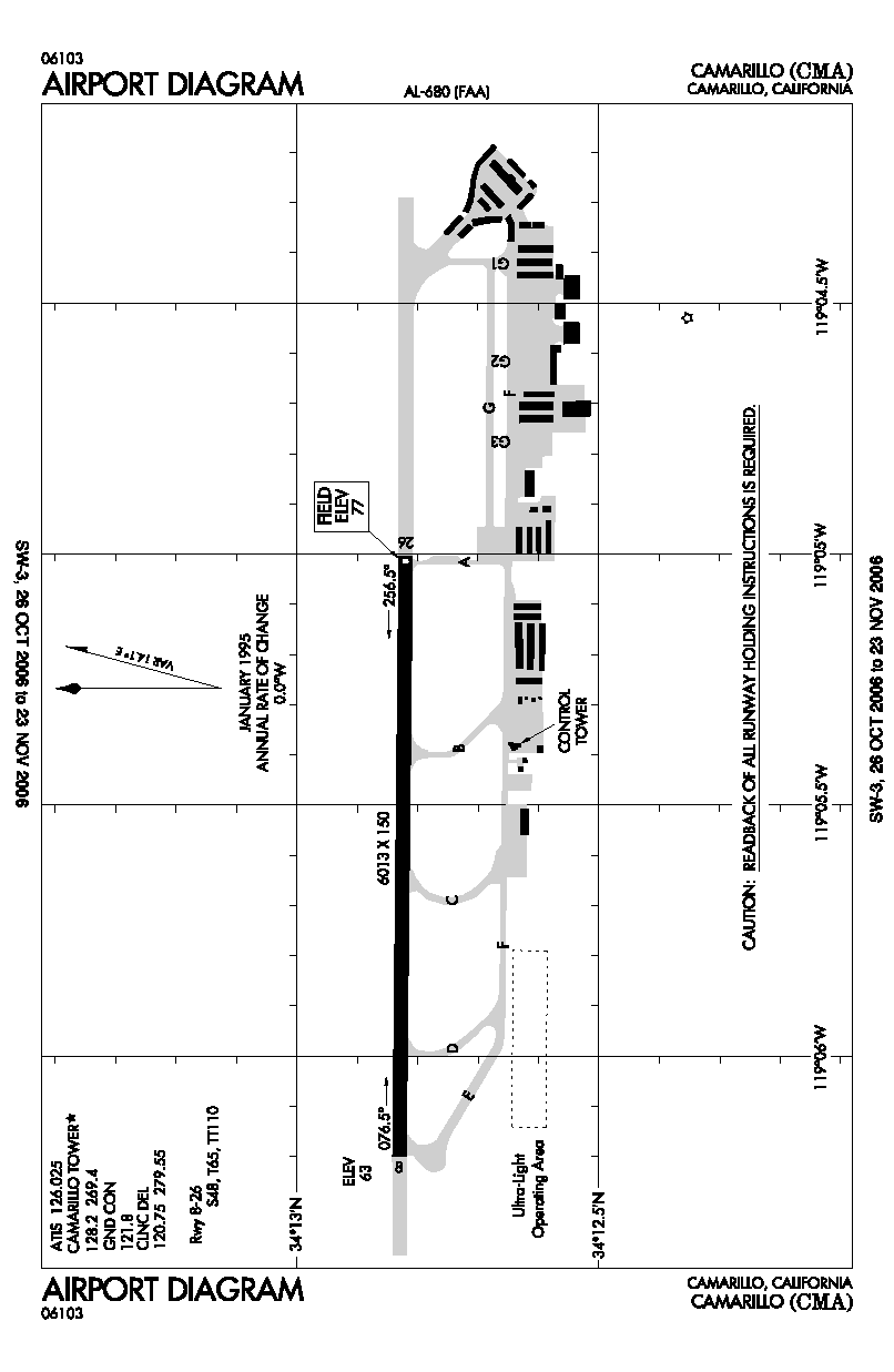
| FAA airport diagram |
| IATA: none – ICAO: KCMA – FAA LID: CMA |
| Summary |
| Airport type |
Public |
| Owner |
County of Ventura |
| Location |
Camarillo, California |
| Elevation AMSL |
77 ft / 23 m |
| Coordinates |
34°12′50″N 119°05′40″W / 34.21389°N 119.09444°W / 34.21389; -119.09444 |
| Runways |
| Direction |
Length |
Surface |
| ft |
m |
| 8/26 |
6,013 |
1,833 |
Asphalt/Concrete |
| Statistics (2006) |
| Aircraft operations |
153,360 |
| Based aircraft |
600 |
| Source: Federal Aviation Administration |
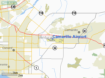
Camarillo Airport (ICAO: KCMA, FAA LID: CMA) is a public airport located three miles (5 km) west of the central business district of Camarillo, a city in Ventura County, California, United States. It is roughly equidistant from Los Angeles, CA and Santa Barbara, CA although it is inland. The airport has one runway and exclusively serves privately-operated general aviation and executive aircraft with no scheduled commercial service.
Before 1970, the airport was known as Oxnard Air Force Base.
According to the FAA's National Plan of Integrated Airport Systems for 2007-2011, it is categorized as a reliever airport.
Although most U.S. airports use the same three-letter location identifier for the FAA and IATA, Camarillo Airport is assigned CMA by the FAA but has no designation from the IATA (which assigned CMA to Cunnamulla Airport in Cunnamulla, Queensland, Australia).
Camarillo Airport was the filming location for an episode of the TV series 24. HistoryCamarillo Airport was originally established in 1942 when the California State Highway Department constructed an auxiliary landing field with a 5,000 ft (1,500 m) runway, which was later extended to 8,000 ft (2,400 m) in 1951 to accommodate what by then had developed into Oxnard Air Force Base.
In the years following, the County of Ventura actively pursued the acquisition of the former military base property from the Department of Defense for commercial airport use, opposed primarily by local residents concerned about the noise of growing commercial traffic. In 1976, the transfer of the airport was finally approved, provided the runway length was shortened to 6,000 ft by displacing the runway threshold on one end. The airport was then formally opened with Channel Islands Aviation providing FBO and initial operations management services. By 1985, the airport was entirely managed by the Ventura County Department of Airports.
Facilities and aircraft
Camarillo Airport covers an area of 650 acres (263 ha) and contains one runway (8/26) which measures 6,013 x 150 ft (1,833 x 46 m). For 12-month period ending June 5, 2006, the airport had 153,360 aircraft operations, an average of 420 per day: 98% general aviation, 2% air taxi and <1% military. There are 600 aircraft based at this airport: 84% single engine, 8% multi engine, 5% ultralights, 3% jet aircraft and 1% helicopters. It is an FAA-towered facility and there are three Fixed Base Operators are headquartered at the airfield.
- The Waypoint Cafe is a restaurant that is adjacent to the runway on the airport property, which was reopened in March 2009 after being closed for refurbishment.
- Civil Air Patrol Camarillo Composite Squadron 61 is based at this airfield, located near Sky Blue Air, at the east end of the airport.
- Channel Islands Aviation Channel Islands Aviation is a Cessna Pilot Center and a FAA Approved Part 141 Flight School. The FBO is located near the end of Taxiway Alpha and has been at Camarillo since the beginning of the facility as a public use airport in 1976. On behalf of the Channel Islands National Park, CIA provide a year round charter service for hikers and campers to Santa Rosa Island.
- Sun Air Jets recently completed construction (2005) of a full-service corporate jet FBO facility on the north-end of the airport near the end of the Charlie taxiway.
- Western Cardinal is a Camarillo-based FBO located between the Golf 1 and Golf 2 taxiways, and built as the second major FBO to serve the airport in the 1980’s.
- The Commemorative Air Force's Southern California Wing and it's museum are located to the west of the Waypoint Cafe in two large hangars. Aircraft include the C-46 'China Doll', an F8F Bearcat, and a B-25J.
The Ventura County Fire and Sheriff's Departments each support large, separate facilities at opposite ends of the field to support new recruit and recurring refreshment training.
The above content comes from Wikipedia and is published under free licenses – click here to read more.
|
 |
(Click on the photo to enlarge) |
|
 |
(Click on the photo to enlarge) |
|
 |
(Click on the photo to enlarge) |
Location
& QuickFacts
|
FAA
Information Effective: |
2006-06-08 |
|
Airport
Identifier: |
CMA |
|
Longitude/Latitude: |
119-05-39.7000W/34-12-49.5000N
-119.094361/34.213750 (Estimated) |
|
Elevation: |
77 ft / 23.47 m (Surveyed) |
|
Land: |
650 acres |
|
From
nearest city: |
3 nautical miles W of Camarillo, CA |
|
Location: |
Ventura County, CA |
|
Magnetic Variation: |
14E (1990) |
Owner
& Manager
|
Ownership: |
Publicly owned |
|
Owner: |
County Of Ventura |
|
Address: |
555 Airport Way
Camarillo, CA 93010-8544 |
|
Phone number: |
805-388-4372 |
|
Manager: |
Chris Hastert |
|
Address: |
555 Airport Way
Camarillo, CA 93010-8544 |
|
Phone number: |
805-388-4246 |
Airport
Operations and Facilities
|
Airport
Use: |
Open to public |
|
Wind
indicator: |
Yes |
|
Segmented
Circle: |
Yes |
|
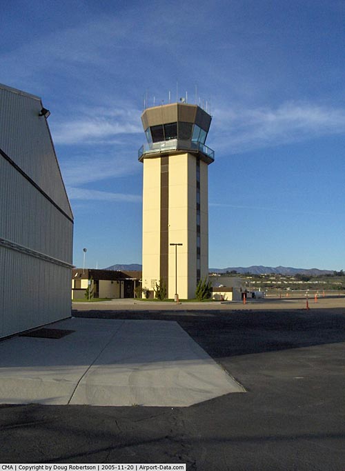
Control
Tower: |
Yes |
|
Attendance
Schedule: |
ALL/ALL/ALL |
|
Lighting
Schedule: |
DUSK-DAWN
WHEN ATCT CLSD ACTVT MIRL RY 08/26 & REIL RYS 08 &
26 - CTAF. |
|
Beacon
Color: |
Clear-Green (lighted land airport) |
|
Landing
fee charge: |
Yes
< 12,500 OVER ACFT
FOR FEE> |
|
Sectional
chart: |
Los Angeles |
|
Region: |
AWP - Western-Pacific |
|
Traffic
Pattern Alt: |
800 ft |
|
Boundary
ARTCC: |
ZLA - Los Angeles |
|
Tie-in
FSS: |
HHR - Hawthorne |
|
FSS
on Airport: |
No |
|
FSS
Phone: |
310-970-0102 |
|
FSS
Toll Free: |
1-800-WX-BRIEF |
|
NOTAMs
Facility: |
CMA (NOTAM-d service avaliable) |
|
Federal Agreements: |
NGPY |
Airport
Communications
Airport
Services
|
Fuel
available: |
100LLA
FUEL AVBL 24 HRS SELF SERVE. |
|
Airframe
Repair: |
MAJOR |
|
Power
Plant Repair: |
MAJOR |
|
Bottled
Oxygen: |
NONE |
|
Bulk
Oxygen: |
LOW |
|
Runway Information
Runway 08/26
|
Dimension: |
6013 x 150 ft / 1832.8 x 45.7 m |
|
Surface: |
ASPH-CONC, Good Condition |
|
Surface
Treatment: |
Rubberized Friction Seal Coat |
|
Weight
Limit: |
Single wheel: 48000 lbs.
Dual wheel: 65000 lbs.
Dual
tandem wheel: 110000 lbs. |
|
Edge
Lights: |
Medium |
|
|
Runway 08 |
Runway 26 |
|
Longitude: |
119-06-15.4596W |
119-05-03.8660W |
|
Latitude: |
34-12-49.8119N |
34-12-49.2278N |
|
Elevation: |
63.00 ft |
77.00 ft |
|
Alignment: |
90 |
127 |
|
Traffic
Pattern: |
Right |
Left |
|
Markings: |
Non-precision instrument, Fair Condition |
Non-precision instrument, Fair Condition |
|
Crossing
Height: |
48.00 ft |
48.00 ft |
|
VASI: |
2-light PAPI on left side |
2-light PAPI on left side |
|
Visual
Glide Angle: |
3.00� |
3.00� |
|
Runway
End Identifier: |
Yes |
Yes |
|
Touchdown
Lights: |
No |
No |
|
Radio Navigation
Aids
|
ID |
Type |
Name |
Ch |
Freq |
Var |
Dist |
|
PAI |
NDB |
Pacoima |
|
370.00 |
15E |
34.0 nm |
|
CPM |
NDB |
Compton |
|
378.00 |
15E |
46.5 nm |
|
NTD |
TACAN |
Point Mugu |
043X |
|
15E |
5.6 nm |
|
VTU |
VOR/DME |
Ventura |
019X |
108.20 |
15E |
6.3 nm |
|
VNY |
VOR/DME |
Van Nuys |
078X |
113.10 |
15E |
30.0 nm |
|
SMO |
VOR/DME |
Santa Monica |
045X |
110.80 |
15E |
34.0 nm |
|
FIM |
VORTAC |
Fillmore |
072X |
112.50 |
15E |
13.6 nm |
|
LAX |
VORTAC |
Los Angeles |
083X |
113.60 |
15E |
37.0 nm |
|
GMN |
VORTAC |
Gorman |
108X |
116.10 |
16E |
37.3 nm |
|
RZS |
VORTAC |
San Marcus |
096X |
114.90 |
14E |
38.0 nm |
|
LHS |
VORTAC |
Lake Hughes |
021X |
108.40 |
15E |
38.1 nm |
|
LAX |
VOT |
San Pedro Hill |
|
113.90 |
|
47.1 nm |
Remarks
- UNLGTD
MTN 1173 FT MSL; BEGINNING 5 MILES FM EAST END RY 26. UNLGTD MTN 1814
FT MSL 5 MILES TO ESE OF APCH END RY 26.
- NO
FORMATION TKOFS OR LDGS.
- NUMEROUS
FLOCKS OF GEESE INVOF ARPT.
- NO
TAKEOFFS 0000-0500 LOCAL TIME (WITHOUT PRIOR PERMISSION).
- WILDLIFE
ON AND INVOF ARPT.
- NO
LDGS/TAXIING/TKOFS ON CHEVERONED AREA EAST OF RY 26 THR.
- NOISE
SENSITIVE ALL QUADRANTS PRACTICE NOISE ABATEMENT/FLY QUIET/PROCS.
- CTN:
HIGH PERFORMANCE MIL. ACFT OPNS INVOF ARPT.
- AVOID
OVERFLIGHT OF PISTOL RANGE LCTD SOUTH OF RY 08 THLD.
Based Aircraft
|
Aircraft
based on field: |
588 |
|
Single
Engine Airplanes: |
502 |
|
Multi
Engine Airplanes: |
46 |
|
Jet Engine
Airplanes: |
4 |
|
Helicopters: |
6 |
|
Ultralights: |
30
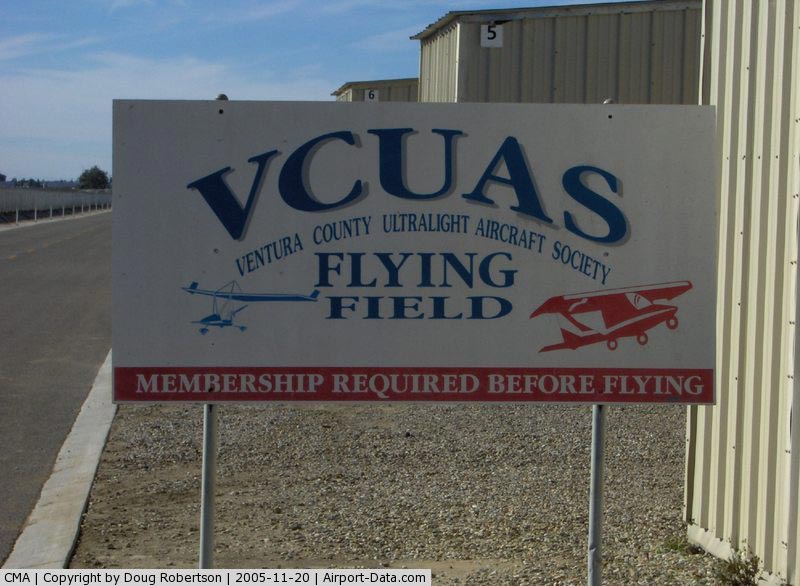
ULTRALIGHT ACTIVITY SW QUAD OF ARPT. |
Operational Statistics
|
Aircraft
Operations: |
558/Day |
|
Air Taxi: |
1.4% |
|
General
Aviation Local: |
45.9% |
|
General
Aviation Itinerant: |
52.6% |
|
Military: |
0.1% |
Camarillo Airport
Address:
Ventura County, CA
Tel:
805-388-4372, 805-388-4246
Images
and information placed above are from
http://www.airport-data.com/airport/CMA/
We
thank them for the data!
| General
Info |
| Country |
United
States |
| State |
CALIFORNIA
|
| FAA ID |
CMA
|
| Latitude |
34-12-49.517N
|
| Longitude |
119-05-39.575W
|
| Elevation |
75 feet
|
| Near City |
CAMARILLO
|
We don't guarantee the information is fresh and accurate. The data may
be wrong or outdated.
For more up-to-date information please refer to other sources.
|
|