 |
|
| Byron Airport |
| IATA: none – ICAO: none – FAA LID: C83 |
| Summary |
| Airport type |
Public |
| Owner |
Contra Costa County |
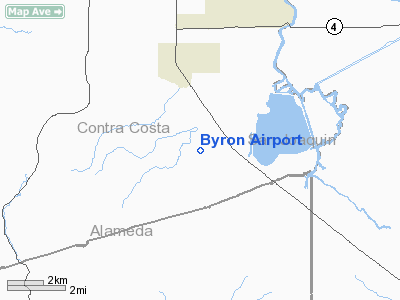
| Location |
Byron, California |
| Elevation AMSL |
79 ft / 24 m |
| Coordinates |
37°49′42″N 121°37′33″W / 37.82833°N 121.62583°W / 37.82833; -121.62583Coordinates: 37°49′42″N 121°37′33″W / 37.82833°N 121.62583°W / 37.82833; -121.62583 |
| Runways |
| Direction |
Length |
Surface |
| ft |
m |
| 12/30 |
4,500 |
1,372 |
Asphalt |
| 5/23 |
3,000 |
914 |
Asphalt |
| Statistics (2004) |
| Aircraft operations |
60,050 |
| Based aircraft |
130 |
| Source: Federal Aviation Administration |
Byron Airport (FAA LID: C83) is a county-owned public-use airport located two miles (3 km) south of the central business district of Byron, a community in Contra Costa County, California, United States. According to the FAA's National Plan of Integrated Airport Systems for 2007-2011, it is categorized as a reliever airport.
On the lee side of the Diablo Range mountains, Byron regularly experiences variable 10-30 knot winds and thermals in the vicinity. Local student pilots often use Byron to practice crosswind landings. Uncontrolled and relatively isolated, Byron supports organizations for skydiving and soaring. For skydiving, the popular drop zone is on the north end of the airport and serviced by Bay Area Skydiving. For soaring, the Northern California Soaring Association offers instructions on weekends in flying gliders. All pilots should be mindful of the variable wind and thermals, rising terrain, and traffic without radios. Facilities and aircraft
Byron Airport covers an area of 1,421 acres (575 ha) which contains two asphalt paved runways: 12/30 measuring 4,500 x 100 ft (1,372 x 30 m) and 5/23 measuring 3,000 x 75 ft (914 x 23 m).
For the 12-month period ending January 29, 2004, the airport had 60,050 aircraft operations, an average of 164 per day: 99.9% general aviation and <1% military. There are 130 aircraft based at this airport: 69% single-engine, 15% glider, 8% multi-engine, 5% jet and 3% ultralight.
The above content comes from Wikipedia and is published under free licenses – click here to read more.
Location
& QuickFacts
|
FAA
Information Effective: |
2006-06-08 |
|
Airport
Identifier: |
C83 |
|
Longitude/Latitude: |
121-37-33.0000W/37-49-42.4000N
-121.625833/37.828444 (Estimated) |
|
Elevation: |
79 ft / 24.08 m (Surveyed) |
|
Land: |
1421 acres |
|
From
nearest city: |
2 nautical miles S of Byron, CA |
|
Location: |
Contra Costa County, CA |
|
Magnetic Variation: |
15E (1995) |
Owner
& Manager
|
Ownership: |
Publicly owned |
|
Owner: |
Contra Costa County |
|
Address: |
550 Sally Ride Dr
Concord, CA 94520 |
|
Phone
number: |
925-646-5722 |
|
Manager: |
Keith Freitas
MANAGER OF ARPTS CONTRA COSTA COUNTY. |
|
Address: |
550 Sally Ride Dr
Concord, CA 94250 |
|
Phone number: |
925-646-5722 |
Airport
Operations and Facilities
|
Airport
Use: |
Open to public |
|
Segmented
Circle: |
Yes |
|
Control
Tower: |
No |
|
Attendance
Schedule: |
ALL/ALL/0800-1800 |
|
Lighting
Schedule: |
DUSK-DAWN
ACTVT MIRL RYS 12/30 & 05/23 & REIL RY 30 - CTAF. |
|
Beacon
Color: |
Clear-Green (lighted land airport) |
|
Sectional
chart: |
San Francisco |
|
Region: |
AWP - Western-Pacific |
|
Boundary
ARTCC: |
ZOA - Oakland |
|
Tie-in
FSS: |
OAK - Oakland |
|
FSS
on Airport: |
No |
|
FSS
Phone: |
510-273-6111 |
|
FSS
Toll Free: |
1-800-WX-BRIEF |
|
NOTAMs
Facility: |
OAK (NOTAM-d service avaliable) |
|
Federal Agreements: |
NGY |
Airport
Communications
|
CTAF: |
123.050 |
|
Unicom: |
123.050 |
Airport
Services
|
Fuel
available: |
100LL
FUEL AVBL 24 HRS BY CREDIT CARD. |
|
Runway Information
Runway 05/23
|
Dimension: |
3000 x 75 ft / 914.4 x 22.9 m |
|
Surface: |
ASPH, Good Condition |
|
Weight
Limit: |
Single wheel: 29500 lbs. |
|
Edge
Lights: |
Medium |
|
|
Runway 05 |
Runway 23 |
|
Longitude: |
121-37-48.4195W |
121-37-15.0582W |
|
Latitude: |
37-49-20.3509N |
37-49-33.7316N |
|
Elevation: |
78.00 ft |
49.00 ft |
|
Alignment: |
63 |
127 |
|
Traffic
Pattern: |
Right |
Left |
|
Markings: |
Basic, Good Condition |
Basic, Good Condition |
|
Crossing
Height: |
0.00 ft |
25.00 ft |
|
VASI: |
|
2-light PAPI on left side |
|
Visual
Glide Angle: |
0.00� |
3.50� |
|
Runway 12/30
|
Dimension: |
4500 x 100 ft / 1371.6 x 30.5 m |
|
Surface: |
ASPH, Good Condition |
|
Weight
Limit: |
Single wheel: 29500 lbs. |
|
Edge
Lights: |
Medium |
|
|
Runway 12 |
Runway 30 |
|
Longitude: |
121-37-53.5205W |
121-37-14.0485W |
|
Latitude: |
37-50-08.4954N |
37-49-36.8929N |
|
Elevation: |
64.00 ft |
48.00 ft |
|
Alignment: |
127 |
127 |
|
Traffic
Pattern: |
Left |
Right |
|
Markings: |
Non-precision instrument, Good Condition |
Non-precision instrument, Good Condition |
|
Crossing
Height: |
0.00 ft |
25.00 ft |
|
VASI: |
|
2-light PAPI on left side |
|
Visual
Glide Angle: |
0.00� |
3.50� |
|
Runway
End Identifier: |
|
Yes
RY 30 REIL OTS INDEFLY. |
|
Obstruction: |
61 ft pole, 1591.0 ft from runway, 261 ft right
of centerline, 22:1 slope to clear |
65 ft hill, 3218.0 ft from runway, 729 ft left
of centerline, 46:1 slope to clear |
|
Radio Navigation
Aids
|
ID |
Type |
Name |
Ch |
Freq |
Var |
Dist |
|
LV |
NDB |
Reiga |
|
374.00 |
16E |
8.6 nm |
|
TCY |
NDB |
Tracy |
|
203.00 |
15E |
11.9 nm |
|
SUU |
TACAN |
Travis |
113X |
|
17E |
29.3 nm |
|
NUQ |
TACAN |
Moffett |
123X |
|
17E |
31.4 nm |
|
TZZ |
VOR |
Travis |
|
116.40 |
17E |
32.2 nm |
|
CCR |
VOR/DME |
Concord |
117X |
117.00 |
17E |
23.8 nm |
|
SJC |
VOR/DME |
San Jose |
088X |
114.10 |
16E |
31.2 nm |
|
MOD |
VOR/DME |
Modesto |
093X |
114.60 |
17E |
34.0 nm |
|
SFO |
VOR/DME |
San Francisco |
105X |
115.80 |
17E |
37.7 nm |
|
ECA |
VORTAC |
Manteca |
107X |
116.00 |
17E |
21.6 nm |
|
OAK |
VORTAC |
Oakland |
115X |
116.80 |
17E |
29.1 nm |
|
LIN |
VORTAC |
Linden |
095X |
114.80 |
17E |
33.0 nm |
|
SAC |
VORTAC |
Sacramento |
099X |
115.20 |
17E |
37.1 nm |
|
OSI |
VORTAC |
Woodside |
086X |
113.90 |
17E |
40.8 nm |
|
SGD |
VORTAC |
Scaggs Island |
058X |
112.10 |
17E |
41.2 nm |
|
SAU |
VORTAC |
Sausalito |
109X |
116.20 |
17E |
42.6 nm |
|
SFO |
VOT |
San Francisco Intl |
|
111.00 |
|
37.8 nm |
|
SAC |
VOT |
Sacramento Executive |
|
111.40 |
|
41.6 nm |
Remarks
- ULTRALIGHT
& SAILPLANE ACTIVITY ON & INVOF ARPT.
- RISING
TERRAIN WITH NUMEROUS WINDMILLS ON RIDGES WEST OF ARPT.
- HANGAR
APRON & TIEDOWN APRON 12500 LBS MAX.
- RY
30 CALM WIND RY.
- 200'
TOWER 5600 FEET FROM RUNWAY 05.
- 100'
TOWER 5100 FEET FROM RUNWAY 23.
Based Aircraft
|
Aircraft
based on field: |
130 |
|
Single
Engine Airplanes: |
90 |
|
Multi
Engine Airplanes: |
10 |
|
Jet Engine
Airplanes: |
6 |
|
Gliders: |
20 |
|
Ultralights: |
4 |
Operational Statistics
|
Aircraft
Operations: |
165/Day |
|
General
Aviation Local: |
91.6% |
|
General
Aviation Itinerant: |
8.3% |
|
Military: |
0.1% |
Byron Airport
Address:
Contra Costa County, CA
Tel:
925-646-5722
Images
and information placed above are from
http://www.airport-data.com/airport/C83/
We
thank them for the data!
| General
Info |
| Country |
United
States |
| State |
CALIFORNIA
|
| FAA ID |
C83
|
| Latitude |
37-49-42.429N
|
| Longitude |
121-37-32.959W
|
| Elevation |
76 feet
|
| Near City |
BYRON
|
We don't guarantee the information is fresh and accurate. The data may
be wrong or outdated.
For more up-to-date information please refer to other sources.
|
|


