 |
|
| Bryant Field |
| IATA: none – ICAO: none – FAA LID: O57 |
| Summary |
| Airport type |
Mono County |
| Operator |
Bridgeport, California |
| Location |
1,971.4 |
| Coordinates |
38°15′45″N 119°13′33″W / 38.2625°N 119.22583°W / 38.2625; -119.22583Coordinates: 38°15′45″N 119°13′33″W / 38.2625°N 119.22583°W / 38.2625; -119.22583 |
| Runways |
| Direction |
Length |
Surface |
| ft |
m |
| 16/34 |
4,239 |
1,292 |
Asphalt |
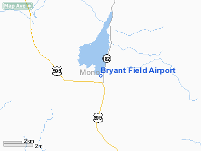
Bryant Field (FAA LID: O57) is a public airport located in Bridgeport, California, USA.
The airport covers 49 acres (200,000 m) and has one runway. It is operated by Mono County.
The above content comes from Wikipedia and is published under free licenses – click here to read more.
Location
& QuickFacts
|
FAA
Information Effective: |
2006-06-08 |
|
Airport
Identifier: |
O57 |
|
Longitude/Latitude: |
119-13-32.5540W/38-15-44.7090N
-119.225709/38.262419 (Estimated) |
|
Elevation: |
6468 ft / 1971.45 m (Estimated) |
|
Land: |
49 acres |
|
From
nearest city: |
0 nautical miles NE of Bridgeport, CA |
|
Location: |
Mono County, CA |
|
Magnetic Variation: |
16E (1985) |
Owner
& Manager
|
Ownership: |
Publicly owned |
|
Owner: |
Mono County |
|
Address: |
Po Box 457
Bridgeport, CA 93517 |
|
Phone
number: |
760-932-5252 |
|
Manager: |
Kelly Garcia
COUNTY ASSISTANT DIRECTOR OF PUBLIC WORKS. |
|
Address: |
P.o. Box 457
Bridgeport, CA 93517 |
|
Phone number: |
760-932-5440 |
Airport
Operations and Facilities
|
Airport
Use: |
Open to public |
|
Wind
indicator: |
Yes |
|
Segmented
Circle: |
Yes |
|
Control
Tower: |
No |
|
Attendance
Schedule: |
UNATNDD |
|
Lighting
Schedule: |
DUSK-DAWN
ACTVT MIRL RY 16/34 - 122.8. |
|
Beacon
Color: |
Clear-Green (lighted land airport)
ROTG BCN LOCATED 1/4 MILE E OF THE ARPT ON TOP OF HILL. |
|
Landing
fee charge: |
No |
|
Sectional
chart: |
San Francisco |
|
Region: |
AWP - Western-Pacific |
|
Traffic
Pattern Alt: |
700 ft |
|
Boundary
ARTCC: |
ZOA - Oakland |
|
Tie-in
FSS: |
RAL - Riverside |
|
FSS
on Airport: |
No |
|
FSS
Phone: |
951-351-3020 |
|
FSS
Toll Free: |
1-800-WX-BRIEF |
|
NOTAMs
Facility: |
RAL (NOTAM-d service avaliable) |
|
Federal Agreements: |
NGY |
Airport
Communications
Airport
Services
|
Fuel
available: |
100
FOR FUEL CALL (760) 932-7153. |
|
Airframe
Repair: |
NONE |
|
Power
Plant Repair: |
NONE |
|
Bottled
Oxygen: |
NONE |
|
Bulk
Oxygen: |
NONE |
|
Runway Information
Runway 16/34
|
Dimension: |
4239 x 60 ft / 1292.0 x 18.3 m |
|
Surface: |
ASPH, Good Condition |
|
Weight
Limit: |
Single wheel: 30000 lbs. |
|
Edge
Lights: |
Medium |
|
|
Runway 16 |
Runway 34 |
|
Elevation: |
6459.00 ft |
6468.00 ft |
|
Traffic
Pattern: |
Right |
Left |
|
Markings: |
Basic, Poor Condition |
Basic, Poor Condition |
|
Displaced
threshold: |
0.00 ft |
389.00 ft |
|
Runway
End Identifier: |
No |
No |
|
Centerline
Lights: |
No |
No |
|
Touchdown
Lights: |
No |
No |
|
Obstruction: |
, 50:1 slope to clear |
5 ft fence, 200.0 ft from runway, 20 ft left
of centerline
APCH RATIO 50:1 TO DSPLCD THR. APCH RATIO TO DSPLCD THR OVER
15 FT ROAD 415 FT FM DSPLCD THR 167 FT LEFT 27:1.
5 FT FENCE & +15 FT ROAD 70 FT L OF CNTRLN 40 FT TO 200
FT FM THR. |
|
Remarks
- BIRDS
TEND TO CONGREGATE ON N END OF RY.
- ESTABD
PRIOR TO 15 MAY 1959.
Based Aircraft
|
Aircraft
based on field: |
2 |
|
Single
Engine Airplanes: |
1 |
|
Helicopters: |
1 |
Operational Statistics
|
Aircraft
Operations: |
62/Week |
|
General
Aviation Local: |
6.3% |
|
General
Aviation Itinerant: |
93.8% |
Bryant Field Airport
Address:
Mono County, CA
Tel:
760-932-5252,
760-932-5440
Images
and information placed above are from
http://www.airport-data.com/airport/O57/
We
thank them for the data!
| General
Info |
| Country |
United
States |
| State |
CALIFORNIA
|
| FAA ID |
O57
|
| Latitude |
38-15-44.709N
|
| Longitude |
119-13-32.554W
|
| Elevation |
6468 feet
|
| Near City |
BRIDGEPORT
|
We don't guarantee the information is fresh and accurate. The data may
be wrong or outdated.
For more up-to-date information please refer to other sources.
|
|


