|
|
| Brackett Field |
 |
| IATA: POC – ICAO: KPOC |
| Summary |
| Airport type |
Public |
| Operator |
County of Los Angeles |
| Location |
La Verne, California |
| Elevation AMSL |
1,011 ft / 308.2 m |
| Coordinates |
34°05′29.93″N 117°46′54.4″W / 34.0916472°N 117.781778°W / 34.0916472; -117.781778Coordinates: 34°05′29.93″N 117°46′54.4″W / 34.0916472°N 117.781778°W / 34.0916472; -117.781778 |
| Runways |
| Direction |
Length |
Surface |
| ft |
m |
| 8L/26R |
3,661 |
1,116 |
Asphalt |
| 8R/26L |
4,839 |
1,475 |
Asphalt |
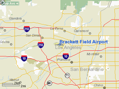
Brackett Field (IATA: POC, ICAO: KPOC) is a public airport located one mile (2 km) southwest of La Verne, in Los Angeles County, California, USA. It was named after Dr. Frank Parkhurst Brackett (1865–1951).
History
Brackett, located about an hour east of the studios in Hollywood, California, has been used for location filming of scenes for a number of TV series and movies. These include Wings of Fire, Airport 1975, Spencer's Pilots (CBS, 1974–1975) The Tim Conway Show and others.
Actor Kent McCord worked for a Fixed Base Operator on the north side of Brackett in the late 1950s.
The field was also the starting point of the Powder Puff Derby in 1974.
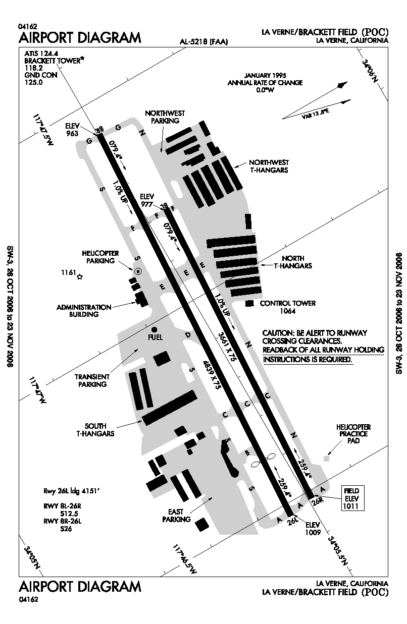
Brackett originally had only one runway (26 / 8), which was paved and had paved taxiways, one on each side. The control tower was built in the late 1960s. In the 1980s, increased traffic (due to the loss of other general aviation airports in the area to urban encroachment) led to the northern taxiway being replaced by a second runway (26R / 8L), which forced the relocation of the control tower a few feet to the north.
Most of the development of the field prior to the 1980s was on the south side, where the Administration Building ("Ad Building") is located. These developments included a Cessna dealership, flying schools and other facilities such as the first metal hangars on the field.
A large, wooden hangar was built on the north side of the field, to house such operations as a Piper dealership and aircraft repair. The hangar burned down circa 1960, was rebuilt, then burned down again about 10 years later, was again rebuilt, then demolished a few years after that to make way for more modern facilities.
Since the 1960s, Brackett has been the home base of Civil Air Patrol Squadron 64.
The above content comes from Wikipedia and is published under free licenses – click here to read more.
Location
& QuickFacts
|
FAA
Information Effective: |
2006-06-08 |
|
Airport
Identifier: |
POC |
|
Longitude/Latitude: |
117-46-54.4090W/34-05-29.9340N
-117.781780/34.091648 (Estimated) |
|
Elevation: |
1011 ft / 308.15 m (Surveyed) |
|
Land: |
276 acres |
|
From
nearest city: |
1 nautical miles SW of La Verne, CA |
|
Location: |
Los Angeles County, CA |
|
Magnetic Variation: |
14E (1985) |
Owner
& Manager
|
Ownership: |
Publicly owned |
|
Owner: |
County Of Los Angeles |
|
Address: |
Po Box 1460
Alhambra, CA 91802-1460 |
|
Phone
number: |
626-300-4602 |
|
Manager: |
Jared Fox-tuck |
|
Address: |
1615 Mc Kinley Avenue
La Verne, CA 91750 |
|
Phone number: |
909-593-1395 |
Airport
Operations and Facilities
|
Airport
Use: |
Open to public |
|
Wind
indicator: |
Yes |
|
Segmented
Circle: |
Yes |
|
Control
Tower: |
Yes |
|
Attendance
Schedule: |
ALL/ALL/ALL |
|
Lighting
Schedule: |
DUSK-DAWN |
|
Beacon
Color: |
Clear-Green (lighted land airport) |
|
Landing
fee charge: |
No |
|
Sectional
chart: |
Los Angeles |
|
Region: |
AWP - Western-Pacific |
|
Traffic
Pattern Alt: |
1000 ft |
|
Boundary
ARTCC: |
ZLA - Los Angeles |
|
Tie-in
FSS: |
RAL - Riverside |
|
FSS
on Airport: |
No |
|
FSS
Phone: |
951-351-3020 |
|
FSS
Toll Free: |
1-800-WX-BRIEF |
|
NOTAMs
Facility: |
POC (NOTAM-d service avaliable) |
|
Federal Agreements: |
NGY |
Airport
Communications
|
CTAF: |
118.200 |
|
Unicom: |
122.950 |
Airport
Services
|
Fuel
available: |
100LLA |
|
Airframe
Repair: |
MAJOR |
|
Power
Plant Repair: |
MAJOR |
|
Bottled
Oxygen: |
LOW |
|
Runway Information
Runway 08L/26R
|
Dimension: |
3661
x 75 ft / 1115.9 x 22.9 m
POMONA POLICE DEPT HELIPORT. |
|
Surface: |
ASPH, Good Condition |
|
Weight
Limit: |
Single wheel: 12500 lbs. |
|
|
Runway 08L |
Runway 26R |
|
Longitude: |
117-47-12.5040W |
117-46-29.0460W |
|
Latitude: |
34-05-32.5180N |
34-05-30.4950N |
|
Elevation: |
976.00 ft |
1011.00 ft |
|
Alignment: |
93 |
127 |
|
Traffic
Pattern: |
Left |
Right |
|
Markings: |
Basic, Good Condition |
Basic, Good Condition |
|
Runway
End Identifier: |
No |
No |
|
Centerline
Lights: |
No |
No |
|
Touchdown
Lights: |
No |
No |
|
Obstruction: |
240 ft hill, 4750.0 ft from runway, 500 ft
left of centerline, 18:1 slope to clear |
15 ft road, 540.0 ft from runway, 159 ft left
of centerline, 22:1 slope to clear |
|
Runway 08R/26L
|
Dimension: |
4839
x 75 ft / 1474.9 x 22.9 m
POMONA POLICE DEPT HELIPORT. |
|
Surface: |
ASPH, Good Condition |
|
Weight
Limit: |
Single wheel: 26000 lbs. |
|
Edge
Lights: |
Medium |
|
|
Runway 08R |
Runway 26L |
|
Longitude: |
117-47-25.7990W |
117-46-28.3550W |
|
Latitude: |
34-05-30.1610N |
34-05-27.4910N |
|
Elevation: |
963.00 ft |
1008.00 ft |
|
Alignment: |
93 |
127 |
|
ILS
Type: |
|
ILS |
|
Traffic
Pattern: |
Right |
Left |
|
Markings: |
Precision instrument, Good Condition |
Precision instrument, Good Condition |
|
Crossing
Height: |
30.00 ft |
18.00 ft |
|
Displaced
threshold: |
0.00 ft |
688.00 ft |
|
VASI: |
4-light PAPI on left side |
4-light PAPI on left side |
|
Visual
Glide Angle: |
3.76� |
3.76� |
|
Runway
End Identifier: |
Yes |
Yes |
|
Centerline
Lights: |
No |
No |
|
Touchdown
Lights: |
No |
No |
|
Obstruction: |
254 ft hill, 3651.0 ft from runway, 800 ft
left of centerline, 13:1 slope to clear |
15 ft road, 200.0 ft from runway, 290 ft left
of centerline
APCH RATIO TO DSPLCD THR 50:1. APCH RATIO TO DSPLCD THR OVER
+65 FT POLES 1988 FT FROM DSPLCD THR, 250 FT L, 30:1. |
|
Helipad H1
|
Dimension: |
50
x 50 ft / 15.2 x 15.2 m
POMONA POLICE DEPT HELIPORT. |
|
Surface: |
ASPH-CONC, |
|
Edge
Lights: |
Low |
|
|
Runway H1 |
Runway |
|
Traffic
Pattern: |
Left |
Left |
|
Radio Navigation
Aids
|
ID |
Type |
Name |
Ch |
Freq |
Var |
Dist |
|
EMT |
NDB |
El Monte |
|
359.00 |
15E |
12.4 nm |
|
SB |
NDB |
Petis |
|
397.00 |
14E |
20.8 nm |
|
CPM |
NDB |
Compton |
|
378.00 |
15E |
26.2 nm |
|
PAI |
NDB |
Pacoima |
|
370.00 |
15E |
33.0 nm |
|
SJY |
NDB |
San Jacinto |
|
227.00 |
14E |
42.9 nm |
|
GWF |
NDB |
Gen William J Fox |
|
282.00 |
15E |
44.5 nm |
|
RIV |
TACAN |
March |
077X |
|
14E |
27.6 nm |
|
RAL |
VOR |
Riverside |
|
112.40 |
15E |
18.6 nm |
|
HDF |
VOR |
Homeland |
|
113.40 |
14E |
35.3 nm |
|
ELB |
VOR/DME |
El Toro |
119X |
117.20 |
14E |
25.1 nm |
|
SMO |
VOR/DME |
Santa Monica |
045X |
110.80 |
15E |
34.0 nm |
|
VCV |
VOR/DME |
Victorville |
031X |
109.40 |
14E |
35.9 nm |
|
VNY |
VOR/DME |
Van Nuys |
078X |
113.10 |
15E |
36.2 nm |
|
POM |
VORTAC |
Pomona |
041X |
110.40 |
15E |
0.8 nm |
|
PDZ |
VORTAC |
Paradise |
059X |
112.20 |
15E |
16.3 nm |
|
SLI |
VORTAC |
Seal Beach |
104X |
115.70 |
15E |
23.0 nm |
|
LAX |
VORTAC |
Los Angeles |
083X |
113.60 |
15E |
33.8 nm |
|
PMD |
VORTAC |
Palmdale |
092X |
114.50 |
15E |
35.3 nm |
|
SNA |
VOT |
Santa Ana |
|
110.00 |
|
25.3 nm |
|
LAX |
VOT |
San Pedro Hill |
|
113.90 |
|
34.6 nm |
Remarks
- NOISE
ABATEMENT PROCEDURES IN EFFECT CTC AMGR (909) 593-1396.
- RWY
08L/26R CLSD NGTS INDEF.
Based Aircraft
|
Aircraft
based on field: |
485 |
|
Single
Engine Airplanes: |
420 |
|
Multi
Engine Airplanes: |
48 |
|
Helicopters: |
17 |
Operational Statistics
|
Aircraft
Operations: |
463/Day |
|
Air Taxi: |
0.3% |
|
General
Aviation Local: |
45.8% |
|
General
Aviation Itinerant: |
53.7% |
|
Military: |
0.2% |
Brackett Field Airport
Address:
Los Angeles County, CA
Tel:
626-300-4602,
909-593-1395
Images
and information placed above are from
http://www.airport-data.com/airport/POC/
We
thank them for the data!
| General
Info |
| Country |
United
States |
| State |
CALIFORNIA
|
| FAA ID |
POC
|
| Latitude |
34-05-29.934N
|
| Longitude |
117-46-54.409W
|
| Elevation |
1011 feet
|
| Near City |
LA VERNE
|
We don't guarantee the information is fresh and accurate. The data may
be wrong or outdated.
For more up-to-date information please refer to other sources.
|
|