 |
|
| Borrego Valley Airport |
 |
| IATA: BXS – ICAO: none – FAA LID: L08 |
| Summary |
| Airport type |
Public |
| Owner |
County of San Diego |
| Serves |
Borrego Springs, California |
| Elevation AMSL |
520 ft / 158 m |
| Coordinates |
33°15′32″N 116°19′16″W / 33.25889°N 116.32111°W / 33.25889; -116.32111 |
| Runways |
| Direction |
Length |
Surface |
| ft |
m |
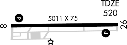
| 8/26 |
5,011 |
1,527 |
Asphalt |
| Statistics (2004) |
| Aircraft operations |
22,000 |
| Based aircraft |
28 |
| Source: Federal Aviation Administration |
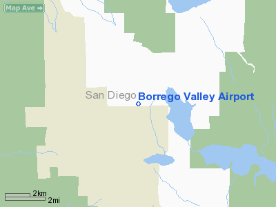
Borrego Valley Airport (IATA: BXS, FAA LID: L08) is a county-owned public-use airport located three nautical miles (6 km) east of the central business district of Borrego Springs, in San Diego County, California, United States.
Facilities and aircraft
Borrego Valley Airport covers an area of 198 acres (80 ha) at an elevation of 520 feet (158 m) above mean sea level. It has one asphalt paved runway (8/26) measuring 5,011 x 75 ft (1,527 x 23 m).
For the 12-month period ending December 31, 2004, the airport had 22,000 aircraft operations, an average of 60 per day: 99.9% general aviation and 0.1% military. At that time there were 28 aircraft based at this airport: 64% single-engine, 7% multi-engine, 7% helicopter and 21% ultralight.
The above content comes from Wikipedia and is published under free licenses – click here to read more.
Location
& QuickFacts
|
FAA
Information Effective: |
2006-06-08 |
|
Airport
Identifier: |
L08 |
|
Longitude/Latitude: |
116-19-15.5000W/33-15-32.5000N
-116.320972/33.259028 (Estimated) |
|
Elevation: |
520 ft / 158.50 m (Surveyed) |
|
Land: |
198 acres |
|
From
nearest city: |
3 nautical miles E of Borrego Springs, CA |
|
Location: |
San Diego County, CA |
|
Magnetic Variation: |
13E (2000) |
Owner
& Manager
|
Ownership: |
Publicly owned |
|
Owner: |
County Of San Diego |
|
Address: |
1960 Joe Crosson Drive
El Cajon, CA 92020-1235 |
|
Phone
number: |
619-956-4800 |
|
Manager: |
Sherry Miller
AIRPORT MANAGER'S OFFICE IS AT GILLESPIE FIELD AIRPORT.
BORREGO VALLEY AIRPORT ON SITE MANAGER IS VICKIE COLE PHONE
760-767-7415 FAX 760-767-5727. |
|
Address: |
1960 Joe Crosson Drive
El Cajon, CA 92020-1235 |
|
Phone number: |
619-520-8963 |
Airport
Operations and Facilities
|
Airport
Use: |
Open to public |
|
Wind
indicator: |
Yes |
|
Segmented
Circle: |
Yes |
|
Control
Tower: |
No |
|
Attendance
Schedule: |
ALL/ALL/0800-1600 |
|
Lighting
Schedule: |
DUSK-DAWN
ACTVT MIRL RY 08/26; PAPI RYS 08 & 26 AND TWY LGTS -
CTAF. |
|
Beacon
Color: |
Clear-Green (lighted land airport) |
|
Landing
fee charge: |
No |
|
Sectional
chart: |
Los Angeles |
|
Region: |
AWP - Western-Pacific |
|
Traffic
Pattern Alt: |
1000 ft |
|
Boundary
ARTCC: |
ZLA - Los Angeles |
|
Tie-in
FSS: |
SAN - San Diego |
|
FSS
on Airport: |
No |
|
FSS
Phone: |
858-277-7043 |
|
FSS
Toll Free: |
1-800-WX-BRIEF |
|
NOTAMs
Facility: |
SAN (NOTAM-d service avaliable) |
|
Federal Agreements: |
NGY |
Airport
Communications
|
CTAF: |
122.800 |
|
Unicom: |
122.800
STAFFED 0800-1600 |
Airport
Services
|
Fuel
available: |
100LL |
|
Airframe
Repair: |
NONE |
|
Power
Plant Repair: |
NONE |
|
Bottled
Oxygen: |
NONE |
|
Bulk
Oxygen: |
NONE |
|
Runway Information
Runway 08/26
|
Dimension: |
5011
x 75 ft / 1527.4 x 22.9 m
RY 08 HAS 400 FT BLAST PAD BYD EOR. |
|
Surface: |
ASPH, Good Condition |
|
Weight
Limit: |
Single wheel: 30000 lbs.
Dual wheel: 54000 lbs.
Dual
tandem wheel: 90000 lbs. |
|
Edge
Lights: |
Medium |
|
|
Runway 08 |
Runway 26 |
|
Longitude: |
116-19-45.0000W |
116-18-46.0000W |
|
Latitude: |
33-15-32.0000N |
33-15-33.0000N |
|
Elevation: |
519.00 ft |
520.00 ft |
|
Alignment: |
89 |
127 |
|
Traffic
Pattern: |
Right |
Left |
|
Markings: |
Basic, Good Condition |
Basic, Good Condition |
|
Crossing
Height: |
42.00 ft |
42.00 ft |
|
VASI: |
2-light PAPI on left side |
2-light PAPI on left side |
|
Visual
Glide Angle: |
3.00� |
3.00� |
|
Runway
End Identifier: |
No |
No |
|
Centerline
Lights: |
No |
No |
|
Touchdown
Lights: |
No |
No |
|
Obstruction: |
10 ft road, 470.0 ft from runway, 27:1 slope
to clear |
, 50:1 slope to clear |
|
Radio Navigation
Aids
|
ID |
Type |
Name |
Ch |
Freq |
Var |
Dist |
|
SJY |
NDB |
San Jacinto |
|
227.00 |
14E |
46.8 nm |
|
NJK |
TACAN |
El Centro |
047X |
|
13E |
41.2 nm |
|
NKX |
TACAN |
Miramar |
033X |
|
15E |
48.1 nm |
|
NKX |
UHF/NDB |
Miramar |
|
352.00 |
15E |
47.3 nm |
|
JLI |
VORTAC |
Julian |
087X |
114.00 |
15E |
15.1 nm |
|
TRM |
VORTAC |
Thermal |
109X |
116.20 |
13E |
23.6 nm |
|
PSP |
VORTAC |
Palm Springs |
102X |
115.50 |
13E |
37.1 nm |
|
SEE |
VOT |
Gillespie Field |
|
110.00 |
|
42.0 nm |
Remarks
- 140
FT TOWER 1600 FT N OF RY 08.
- DURING
HOT WX HEAVY ACFT PARK ON CONCRETE PADS.
- AEROBATIC
ACTIVITY N SIDE OF ARPT DURING DAYLIGHT HRS FROM SURFACE TO 5000 FT
MSL.
- DO
NOT OVERFLY ELEMENTARY SCHOOL SW OF ARPT.
- BE
AWARE OF FREQUENT CHANGES IN WIND DIRECTION.
- ALL
ACFT TFC PATS TO S.
Based Aircraft
|
Aircraft
based on field: |
31 |
|
Single
Engine Airplanes: |
21 |
|
Multi
Engine Airplanes: |
2 |
|
Helicopters: |
2 |
|
Ultralights: |
6 |
Operational Statistics
|
Aircraft
Operations: |
61/Day |
|
General
Aviation Local: |
20.0% |
|
General
Aviation Itinerant: |
79.9% |
|
Military: |
0.1% |
Borrego Valley Airport
Address:
San Diego County, CA
Tel:
619-956-4800,
619-520-8963
Images
and information placed above are from
http://www.airport-data.com/airport/L08/
We
thank them for the data!
| General
Info |
| Country |
United
States |
| State |
CALIFORNIA
|
| FAA ID |
L08
|
| Latitude |
33-15-32.500N
|
| Longitude |
116-19-15.500W
|
| Elevation |
520 feet
|
| Near City |
BORREGO
SPRINGS |
We don't guarantee the information is fresh and accurate. The data may
be wrong or outdated.
For more up-to-date information please refer to other sources.
|
|


