|
|
| Blythe Airport |
 |
| IATA: BLH – ICAO: KBLH |
| Summary |
| Airport type |
Public |
| Location |
Riverside County, west of Blythe, California |
| Elevation AMSL |
399 ft / 122 m |
| Coordinates |
33°37′09.0″N 114°43′00.8″W / 33.61917°N 114.716889°W / 33.61917; -114.716889Coordinates: 33°37′09.0″N 114°43′00.8″W / 33.61917°N 114.716889°W / 33.61917; -114.716889 |
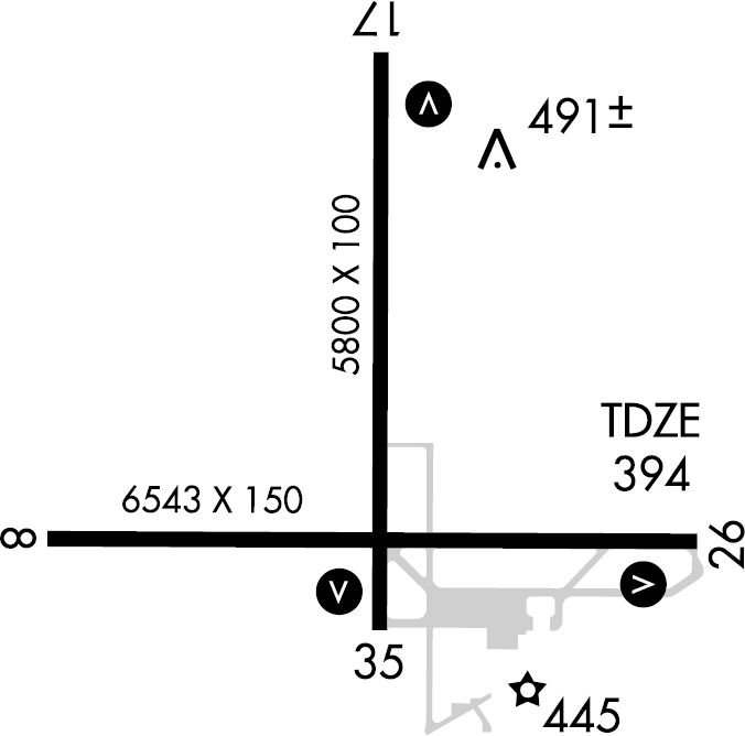
| Runways |
| Direction |
Length |
Surface |
| ft |
m |
| 8/26 |
6,543 |
1,994 |
Asphalt |
| 17/35 |
5,800 |
1,768 |
Asphalt |
Blythe Airport (IATA: BLH, ICAO: KBLH) is a public airport located six miles (9.7 km) west of Blythe, serving Riverside County, California, USA. The airport has two runways and is mostly used for general aviation. Facilities
Blythe Airport has two runways:
- Runway 8/26: 6,543 x 150 ft (1,994 x 46 m). Surface: Asphalt
- Runway 17/35: 5,800 x 100 ft (1,768 x 30 m). Surface: Asphalt
History
Prior to World War II, Blythe Airport was established by the Civil Aeronautics Administration in the late 1930s as an emergency landing field on the Los Angeles to Phoenix airway. A commercial airport was opened in April 1940. During World War II the airfield was known as Blythe Army Air Base (also known as Bishop Army Airfield) and was used by the United States Army Air Forces.
The field was built for the I Troop Carrier Command but was given up by that command, without ever occupying it, to the Fourth Air Force as part of the United States Army Desert Training Center (DTC) was established by General George S. Patton shortly after the outbreak of the war, Blythe was the only air field with construction already under way. For six months, the air field served as the sole air support base for the Army maneuvers under way at the DTC.
The 46th Bombardment Group and later the 85th Bombardment Group occupied the field during the CAMA days and flew a variety of planes including A-31 Vengeances and A-36 Apaches. Once air fields were established at three new locations within the DTC (Thermal, Rice and Desert Center), Blythe field was no longer required for the Army's desert exercises. After General Patton was sent to North Africa, the name of the training center was changed to the California-Arizona Maneuver Area (CAMA). The 46th and 85th Bomb Groups were reassigned elsewhere and Blythe's mission was changed to the training of combat air crews prior to shipment overseas.
Four-engined B-17 Flying Fortresses and B-24 Liberators replaced the dive bombers as part of the Second Air Force 16th Bombardment Training Wing 358th Combat Crew Training School.
Known units assigned to Blythe Army Airfield were:
- 46th Bombardment Group (Light) 23 May 1942-November 1942. A-20 Havoc
- 85th Bombardment Group (Light) 23 May 1942-November 1942. A-20 Havoc
- 85th Bombardment Group (Dive) 2 November-11 December 1942 A-24 Dauntlesses
- 34th Bombardment Group (Heavy) 15 December 1942-April 1944. B-17 Flying Fortresses and B-24 Liberators
- 398th Bombardment Group (Heavy) April 1943 B-17 Flying Fortresses
At its peak in December, 1943, the base had a population just short of 8000 uniformed and civilian personnel. This was twice the population of the city of Blythe, the only community within a one hundred mile radius. By April, 1944 only a housekeeping force was assigned to the base, now downgraded from Air Base to Air Field status. By July 1944 the field was abandoned by the Army and declared surplus. 126 airmen were killed in Blythe Army Air Base-related accidents.
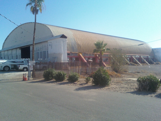 | |
Photo of the main hangar at Blythe Airport taken in August 2009. |
Blythe Army Air Field later became a sub-base of Muroc Army Air Field (now Edwards Air Force Base) on 30 June 1945, and was inactivated on 18 October 1945, although during October-December 1946, the 477th Composite Group (Medium) used the airfield for desert maneuvers, flying B-25 Mitchells. The War Assets Administration returned the airfield to civil control in 1947.
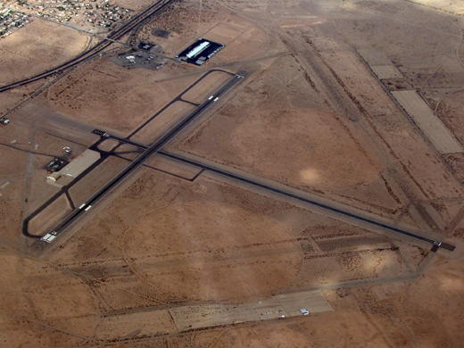
Today a modern airport has been built on the site of the former wartime airfield; however most of the area of what was Blythe Army Air Base has been abandoned to the natural landscape being empty and undeveloped. Deteriorating abandoned runways and concrete parking ramps are clearly visible in aerial photography.
The above content comes from Wikipedia and is published under free licenses – click here to read more.
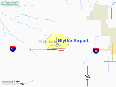
Location
& QuickFacts
|
FAA
Information Effective: |
2006-06-08 |
|
Airport
Identifier: |
BLH |
|
Longitude/Latitude: |
114-43-00.8000W/33-37-09.0000N
-114.716889/33.619167 (Estimated) |
|
Elevation: |
399 ft / 121.62 m (Surveyed) |
|
Land: |
3904 acres |
|
From
nearest city: |
6 nautical miles W of Blythe, CA |
|
Location: |
Riverside County, CA |
|
Magnetic Variation: |
13E (2005) |
Owner
& Manager
|
Ownership: |
Publicly owned |
|
Owner: |
Riverside County Aviation Div |
|
Address: |
3525 14th Street
Riverside, CA 92501-3813 |
|
Phone
number: |
951-863-2530
TOM TURNER, AIRPORT DIVISION, EXT. 358 |
|
Manager: |
Charles Hull
CITY OF BLYTHE ASSISTANT CITY MANAGER. |
|
Address: |
235 N. Broadway
Blythe, CA 92225 |
|
Phone number: |
760-922-6161 |
Airport
Operations and Facilities
|
Airport
Use: |
Open to public |
|
Wind
indicator: |
Yes |
|
Segmented
Circle: |
Yes |
|
Control
Tower: |
No |
|
Attendance
Schedule: |
ALL/ALL/0700-1700 |
|
Lighting
Schedule: |
DUSK-DAWN
ACTVT MIRL RYS 17/35; 08/26; AND VASI RYS 17; 35 & 26
- CTAF. |
|
Beacon
Color: |
Clear-Green (lighted land airport) |
|
Landing
fee charge: |
No |
|
Sectional
chart: |
Phoenix |
|
Region: |
AWP - Western-Pacific |
|
Traffic
Pattern Alt: |
800 ft |
|
Boundary
ARTCC: |
ZLA - Los Angeles |
|
Tie-in
FSS: |
RAL - Riverside |
|
FSS
Phone: |
951-351-3020 |
|
FSS
Toll Free: |
1-800-WX-BRIEF |
|
NOTAMs
Facility: |
BLH (NOTAM-d service avaliable) |
|
Federal Agreements: |
NGPY |
Airport
Communications
|
CTAF: |
122.800 |
|
Unicom: |
122.800 |
Airport
Services
|
Fuel
available: |
100LLA |
|
Airframe
Repair: |
MAJOR |
|
Power
Plant Repair: |
MAJOR |
|
Bottled
Oxygen: |
NONE |
|
Bulk
Oxygen: |
NONE |
|
Runway Information
Runway 08/26
|
Dimension: |
6543 x 150 ft / 1994.3 x 45.7 m |
|
Surface: |
ASPH, Good Condition |
|
Weight
Limit: |
Single wheel: 80000 lbs.
Dual wheel: 160000 lbs.
Dual
tandem wheel: 300000 lbs. |
|
Edge
Lights: |
Medium |
|
|
Runway 08 |
Runway 26 |
|
Longitude: |
114-43-39.8259W |
114-42-22.4640W |
|
Latitude: |
33-36-59.7683N |
33-36-59.5333N |
|
Elevation: |
397.00 ft |
396.00 ft |
|
Alignment: |
90 |
127 |
|
Traffic
Pattern: |
Left |
Left |
|
Markings: |
Non-precision instrument, Good Condition |
Precision instrument, Good Condition |
|
Crossing
Height: |
0.00 ft |
42.00 ft |
|
VASI: |
|
4-box on left side |
|
Visual
Glide Angle: |
0.00� |
3.00� |
|
Runway
End Identifier: |
No |
No |
|
Centerline
Lights: |
No |
No |
|
Touchdown
Lights: |
No |
No |
|
Runway 17/35
|
Dimension: |
5800 x 100 ft / 1767.8 x 30.5 m |
|
Surface: |
ASPH, Good Condition |
|
Weight
Limit: |
Single wheel: 52000 lbs.
Dual wheel: 76000 lbs.
Dual
tandem wheel: 135000 lbs. |
|
Edge
Lights: |
Medium |
|
|
Runway 17 |
Runway 35 |
|
Longitude: |
114-43-00.2703W |
114-43-00.5427W |
|
Latitude: |
33-37-48.1258N |
33-36-50.7511N |
|
Elevation: |
399.00 ft |
394.00 ft |
|
Alignment: |
127 |
0 |
|
Traffic
Pattern: |
Left |
Left |
|
Markings: |
Basic, Good Condition |
Basic, Good Condition |
|
Crossing
Height: |
40.00 ft |
40.00 ft |
|
VASI: |
4-box on left side |
4-box on left side |
|
Visual
Glide Angle: |
3.00� |
3.00� |
|
Runway
End Identifier: |
No |
No |
|
Centerline
Lights: |
No |
No |
|
Touchdown
Lights: |
No |
No |
|
Radio Navigation
Aids
|
ID |
Type |
Name |
Ch |
Freq |
Var |
Dist |
|
OEG |
NDB |
Golden Eagle |
|
413.00 |
12E |
48.0 nm |
|
BLH |
VORTAC |
Blythe |
121X |
117.40 |
14E |
2.6 nm |
|
PKE |
VORTAC |
Parker |
126X |
117.90 |
15E |
29.1 nm |
Remarks
- ACFT
OVER 12500 LBS AVOID HOUSING AREA 1.5 NM SW BLO 2000' FINAL APCH RWY
35 BE ESTABD 2 NM FM TOUCHDOWN.
- DEP
FM RY 17 MAKE CLIMBING LEFT TURN SOON AS SAFETY PERMITS. USE WIDE TFC
PATTERN FOR RYS 26 & 35.
- POWER
PLANT 1 MILE EAST OF ARPT PRODUCING THERMAL PLUMES; AVOID LOW ALTITUDE
DIRECT OVERFLIGHT OF THE POWER PLANT.
Based Aircraft
|
Aircraft
based on field: |
11 |
|
Single
Engine Airplanes: |
9 |
|
Multi
Engine Airplanes: |
2 |
Operational Statistics
|
Aircraft
Operations: |
69/Day |
|
General
Aviation Local: |
49.7% |
|
General
Aviation Itinerant: |
49.7% |
|
Military: |
0.6% |
Blythe Airport
Address:
Riverside County, CA
Tel:
951-863-2530, 760-922-6161
Images
and information placed above are from
http://www.airport-data.com/airport/BLH/
We
thank them for the data!
| General
Info |
| Country |
United
States |
| State |
CALIFORNIA
|
| FAA ID |
BLH
|
| Latitude |
33-37-08.986N
|
| Longitude |
114-43-00.755W
|
| Elevation |
397 feet
|
| Near City |
BLYTHE
|
We don't guarantee the information is fresh and accurate. The data may
be wrong or outdated.
For more up-to-date information please refer to other sources.
|
|