 |
|
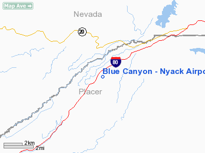
Blue Canyon - Nyack Airport |
|
|
Location
& QuickFacts
|
FAA
Information Effective: |
2006-06-08 |
|
Airport
Identifier: |
BLU |
|
Longitude/Latitude: |
120-42-35.1000W/39-16-29.9000N
-120.709750/39.274972 (Estimated) |
|
Elevation: |
5284 ft / 1610.56 m (Estimated) |
|
Land: |
90 acres |
|
From
nearest city: |
1 nautical miles S of Emigrant Gap, CA |
|
Location: |
Placer County, CA |
|
Magnetic Variation: |
16E (1985) |
Owner
& Manager
|
Ownership: |
Publicly owned |
|
Owner: |
County Of Placer |
|
Address: |
11444 B Ave, Bldg 104b
Auburn, CA 95603 |
|
Phone
number: |
530-889-7564 |
|
Manager: |
John Weber |
|
Address: |
11444 B Ave, Bldg 104b
Auburn, CA 95603 |
|
Phone
number: |
530-889-7500
LOCATED AT DEPT OF PUBLIC WORKS OFFICE, AUBURN, CA. |
Airport
Operations and Facilities
|
Airport
Use: |
Open to public |
|
Wind
indicator: |
Yes |
|
Segmented
Circle: |
No |
|
Control
Tower: |
No |
|
Attendance
Schedule: |
UNATNDD
ARPT CLSD WINTERS DUE TO SNOW. |
|
Lighting
Schedule: |
RDO-CTL
ROTG BCN OTS INDEFLY . |
|
Beacon
Color: |
Clear-Green (lighted land airport) |
|
Landing
fee charge: |
No |
|
Sectional
chart: |
San Francisco |
|
Region: |
AWP - Western-Pacific |
|
Traffic
Pattern Alt: |
1000 ft |
|
Boundary
ARTCC: |
ZOA - Oakland |
|
Tie-in
FSS: |
RIU - Rancho Murieta |
|
FSS
on Airport: |
No |
|
FSS
Phone: |
916-354-0161 |
|
FSS
Toll Free: |
1-800-WX-BRIEF |
|
NOTAMs
Facility: |
BLU (NOTAM-d service avaliable) |
Airport
Communications
Airport
Services
|
Airframe
Repair: |
NONE |
|
Power
Plant Repair: |
NONE |
|
Bottled
Oxygen: |
NONE |
|
Bulk
Oxygen: |
NONE |
|
Runway Information
Runway 15/33
|
Dimension: |
3300 x 50 ft / 1005.8 x 15.2 m |
|
Surface: |
ASPH, Good Condition |
|
Weight
Limit: |
Single wheel: 12000 lbs. |
|
Edge
Lights: |
Medium
MIRL RY 15/33 OTS INDEFLY . |
|
|
Runway 15 |
Runway 33 |
|
Longitude: |
120-42-39.6251W |
120-42-30.6529W |
|
Latitude: |
39-16-45.7757N |
39-16-13.9215N |
|
Elevation: |
5284.00 ft |
5246.00 ft |
|
Traffic
Pattern: |
Left |
Left |
|
Markings: |
Basic, Fair Condition |
Basic, Poor Condition |
|
Runway
End Identifier: |
No |
No |
|
Centerline
Lights: |
No |
No |
|
Touchdown
Lights: |
No |
No |
|
Obstruction: |
20 ft tree, 750.0 ft from runway, 110 ft left
of centerline, 27:1 slope to clear
RWY 15 +4 FT BRUSH 100 FT FM THLD 125 FT LEFT TO 125 FT RIGHT |
15 ft tree, 400.0 ft from runway, 13:1 slope to
clear |
|
Radio Navigation
Aids
|
ID |
Type |
Name |
Ch |
Freq |
Var |
Dist |
|
MY |
NDB |
Halow |
|
222.00 |
16E |
42.4 nm |
|
OVE |
NDB |
Oroville |
|
212.00 |
16E |
44.4 nm |
|
BAB |
TACAN |
Beale |
023X |
|
16E |
35.1 nm |
|
SWR |
VOR/DME |
Squaw Valley |
079X |
113.20 |
16E |
21.3 nm |
|
HNW |
VOR/DME |
Hangtown |
102X |
115.50 |
17E |
33.1 nm |
|
MYV |
VOR/DME |
Marysville |
045X |
110.80 |
16E |
41.6 nm |
|
MCC |
VOR/DME |
Mc Clellan |
029X |
109.20 |
17E |
48.9 nm |
Remarks
- ARPT
CLSD SS-SR.
- DO
NOT ATTEMPT TO LAND WITH SNOW ON THE RUNWAY. NO SNOW REMOVAL SERVICES
ARE PROVIDED.
- PREDATES
TO 1958 FAA ACT.
Operational Statistics
|
Aircraft
Operations: |
24/Week |
|
General
Aviation Itinerant: |
91.7% |
|
Military: |
8.3% |
Blue Canyon - Nyack Airport
Address:
Placer County, CA
Tel:
530-889-7564, 530-889-7500
Images
and information placed above are from
http://www.airport-data.com/airport/BLU/
We
thank them for the data!
| General
Info |
| Country |
United
States |
| State |
CALIFORNIA
|
| FAA ID |
BLU
|
| Latitude |
39-16-29.640N
|
| Longitude |
120-42-33.765W
|
| Elevation |
5284 feet
|
| Near City |
EMIGRANT
GAP |
We don't guarantee the information is fresh and accurate. The data may
be wrong or outdated.
For more up-to-date information please refer to other sources.
|
|


