|
|
| Big Bear City Airport |
 |
| IATA: RBF – ICAO: none – FAA LID: L35 |
| Summary |
| Airport type |
Public |
| Owner |
Big Bear Airport District |
| Location |
Big Bear City, California |
| Elevation AMSL |
6,752 ft / 2,058 m |
| Coordinates |
34°15′50″N 116°51′22″W / 34.26389°N 116.85611°W / 34.26389; -116.85611 |
| Website |
BigBearCityAirport.com |
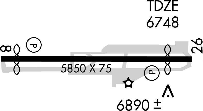
| Runways |
| Direction |
Length |
Surface |
| ft |
m |
| 8/26 |
5,850 |
1,783 |
Asphalt |
| Statistics (2004) |
| Aircraft operations |
30,000 |
| Based aircraft |
141 |
| Source: Federal Aviation Administration |
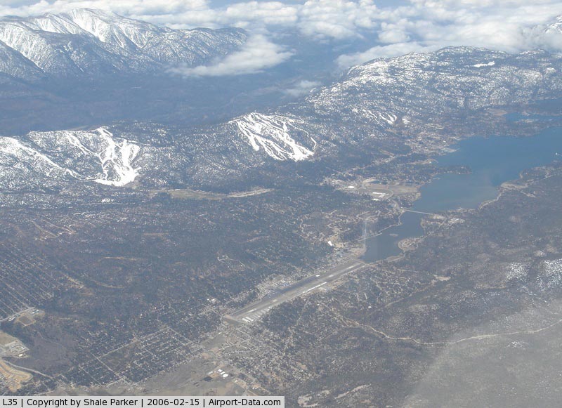
Big Bear City Airport (IATA: RBF, FAA LID: L35) is a public airport located in Big Bear City, San Bernardino County, California, United States. Arrival and Departure
Big Bear City Airport has published specific flight rules for aircraft. At the time of writing, the established procedure is for inbound traffic to fly in over the ski slopes at 9,500 feet, and for departing traffic to fly at or below 8,500 feet. As this airport is at fairly high altitude and routinely experiences density altitudes of 9,000 feet or higher, it's important (perhaps more than usual) for pilots to double-check the performance tables in their aircraft manuals to ensure that they will be able to take off. The flight rules also contain noise abatement procedures that help the airport, its tenants, and its guests to be better neighbors to the community.
The calm wind runway (26) ends at the eastern terminus of Big Bear Lake. There is no suitable landing area for several miles, as the terrain is covered almost completely with coniferous trees and houses. If an airplane can make it over the lake and past the dam, its pilot will enjoy "instant altitude" - there is a deep fissure between mountain ridges that leads roughly south towards San Bernardino. One must be cautious of possible turbulence and mountain wave/rotor activity in this area, but aside from that, it is an option for pilots who are having trouble climbing or maintaining altitude.
Facilities and aircraft
Big Bear City Airport covers an area of 117 acres (47 ha) which contains one asphalt paved runway (8/26) measuring 5,850 x 75 ft (1,783 x 23 m).
There are two restaurants in the terminal building. Barnstormer (American cuisine) is open for breakfast and lunch and then closes until dinner. The Chinese restaurant, upstairs, is open all day.
Average of 81 operations per day.
| Commercial |
Air Taxi |
GA Local |
GA Transient |
Military |
| 0 |
0 |
30 |
46 |
5 |
161 aircraft based at airport
| Single Engine |
Multi Engine |
Jet |
Helicopter |
Glider/ Ultralight |
Military |
| 151 |
6 |
1 |
0 |
4 |
0 |
Accidents and incidents
- Aeroméxico Flight 498 Cerritos air disaster: A private aircraft owned by William Kramer en route to Big Bear City from Zamperini Field in Torrance collided with a Douglas DC-9 owned by Aeroméxico en route to Los Angeles International Airport from various Mexican cities. Both planes crashed, causing all of the people on both planes to die and some residents in Cerritos to die or sustain injuries.
- A small jet crash occcured on the 20th of February after leaving San Bernardino International Airport, but neither the pilot nor the passengers were injured.
The above content comes from Wikipedia and is published under free licenses – click here to read more.
|
 |
(Click on the photo to enlarge) |
Location
& QuickFacts
|
FAA
Information Effective: |
2006-06-08 |
|
Airport
Identifier: |
L35 |
|
Longitude/Latitude: |
116-51-21.7000W/34-15-49.6000N
-116.856028/34.263778 (Estimated) |
|
Elevation: |
6752 ft / 2058.01 m (Surveyed) |
|
Land: |
117
acres |
|
From
nearest city: |
0 nautical miles W of Big Bear City, CA |
|
Location: |
San Bernardino County, CA |
|
Magnetic Variation: |
14E (2000) |
Owner
& Manager
|
Ownership: |
Publicly
owned |
|
Owner: |
Big
Bear Airport Dist |
|
Address: |
P O Box 755
Big Bear City, CA 92314-0755 |
|
Phone
number: |
909-585-3219 |
|
Manager: |
Garry Dokter |
|
Address: |
Po Box 755
Big Bear City, CA 92314-0755 |
|
Phone number: |
909-585-3219 |
Airport
Operations and Facilities
|
Airport Use: |
Open
to public |
|
Wind
indicator: |
Yes |
|
Segmented
Circle: |
Yes |
|
Control
Tower: |
No |
|
Attendance
Schedule: |
ALL/ALL/0800-1700 |
|
Lighting
Schedule: |
DUSK-DAWN
ACTVT MIRL RY 08/26 - CTAF.
PAPI RYS 08 & 26 OPER CONT. |
|
Beacon
Color: |
Clear-Green (lighted land airport) |
|
Landing
fee charge: |
No |
|
Sectional
chart: |
Los
Angeles |
|
Region: |
AWP
- Western-Pacific |
|
Traffic
Pattern Alt: |
1200 ft |
|
Boundary
ARTCC: |
ZLA
- Los Angeles |
|
Tie-in
FSS: |
RAL
- Riverside |
|
FSS
on Airport: |
No |
|
FSS
Phone: |
951-351-3020 |
|
FSS
Toll Free: |
1-800-WX-BRIEF |
|
NOTAMs
Facility: |
RAL (NOTAM-d service avaliable) |
|
Federal Agreements: |
NGY |
Airport
Communications
|
CTAF: |
122.725 |
|
Unicom: |
122.725
|
Airport
Services
|
Fuel available: |
100LLA
JET A FUEL AVBL 0800-1600. |
|
Airframe Repair: |
MAJOR |
|
Power Plant Repair: |
MAJOR |
|
Bottled
Oxygen: |
NONE |
|
Bulk
Oxygen: |
NONE |
|
Runway Information
Runway 08/26
|
Dimension: |
5850
x 75 ft / 1783.1 x 22.9 m |
|
Surface: |
ASPH,
Good Condition |
|
Weight
Limit: |
Single
wheel: 12500 lbs. |
|
Edge
Lights: |
Medium |
| |
Runway
08 |
Runway
26 |
|
Longitude: |
116-51-56.5570W |
116-50-46.8850W |
|
Latitude: |
34-15-49.5020N |
34-15-49.7823N |
|
Elevation: |
6750.00 ft |
6751.00 ft |
|
Alignment: |
90 |
127 |
|
Traffic
Pattern: |
Right |
Left |
|
Markings: |
Non-precision instrument, Good Condition |
Non-precision instrument, Good Condition |
|
Crossing
Height: |
26.00
ft |
26.00
ft |
|
Displaced
threshold: |
370.00 ft |
600.00 ft |
|
VASI: |
2-light PAPI on left side |
2-light PAPI on left side |
|
Visual
Glide Angle: |
4.00� |
4.00� |
|
Runway
End Identifier: |
No |
No |
|
Centerline
Lights: |
No |
No |
|
Touchdown
Lights: |
No |
No |
|
Obstruction: |
,
50:1 slope to clear
APCH RATIO TO DSPLCD THR OVER +15' ROAD 480' FM DSPLCD THR
32:1
ROAD & 6' FENCE 110' FM THR PERPENDICULAR TO CNTRLN. |
40
ft trees, 1000.0 ft from runway, 100 ft left of centerline,
20:1 slope to clear
RWY 26 APCH RATIO TO DSPLCD THR 20:1; APCH RATIO TO DSPLCD
THR OVER +50 FT TREES 1000 FT FM DSPLCD THR 100 FT LEFT 20:1.
ROAD & 6' FENCE 100' FM THR 125' RIGHT. |
|
Radio Navigation
Aids
|
ID |
Type |
Name |
Ch |
Freq |
Var |
Dist |
|
SB |
NDB |
Petis |
|
397.00 |
14E |
28.3
nm |
|
SJY |
NDB |
San
Jacinto |
|
227.00 |
14E |
29.1
nm |
|
RIV |
TACAN |
March |
077X |
|
14E |
29.9
nm |
|
NXP |
TACAN |
Coyote |
063X |
|
14E |
34.8
nm |
|
HDF |
VOR |
Homeland |
|
113.40 |
14E |
33.6
nm |
|
RAL |
VOR |
Riverside |
|
112.40 |
15E |
35.0
nm |
|
VCV |
VOR/DME |
Victorville |
031X |
109.40 |
14E |
33.1
nm |
|
PSP |
VORTAC |
Palm
Springs |
102X |
115.50 |
13E |
31.8
nm |
|
HEC |
VORTAC |
Hector |
074X |
112.70 |
15E |
37.5
nm |
|
PDZ |
VORTAC |
Paradise |
059X |
112.20 |
15E |
39.5
nm |
|
DAG |
VORTAC |
Daggett |
079X |
113.20 |
15E |
44.2
nm |
|
POM |
VORTAC |
Pomona |
041X |
110.40 |
15E |
47.6
nm |
Remarks
- MOUNTAINS
ALL QUADRANTS; PEAK HAZARD LGTS SE; S; & NW.
-
< NOISE OF INTEREST THE IN PROCEDURES QUIET) (FLY
PRACTICE AREA; SENSITIVE>
- NOISE
ABATEMENT PROCEDURES; AVOID OVERFLYING OF HIGH SCHOOL 1 MILE EAST AT
ALL TIMES.
- ON
TKOF MAKE 10 DEG LEFT TURN AT END OF RY TO AVOID HOUSING TO EAST AND
ELEMENTARY SCHOOL TO WEST OF ARPT.
Based Aircraft
|
Aircraft
based on field: |
141 |
|
Single
Engine Airplanes: |
133 |
|
Multi
Engine Airplanes: |
4 |
|
Gliders: |
1 |
|
Ultralights: |
3 |
Operational Statistics
|
Aircraft
Operations: |
83/Day |
|
General
Aviation Local: |
37.3% |
|
General
Aviation Itinerant: |
56.0% |
|
Military: |
6.7% |
Big Bear City Airport
Address:
San Bernardino County, CA
Tel:
909-585-321
Images
and information placed above are from
http://www.airport-data.com/airport/L35/
We
thank them for the data!
| General
Info |
| Country |
United
States |
| State |
CALIFORNIA
|
| FAA ID |
L35
|
| Latitude |
34-15-49.030N
|
| Longitude |
116-51-16.110W
|
| Elevation |
6748 feet
|
| Near City |
BIG BEAR
CITY |
We don't guarantee the information is fresh and accurate. The data may
be wrong or outdated.
For more up-to-date information please refer to other sources.
|
|