|
|
| Bermuda Dunes Airport |
 |
| IATA: UDD – ICAO: KUDD – FAA LID: UDD |
| Summary |
| Airport type |
Bermuda Dunes Airport Corp. |
| Operator |
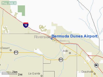
Palm Springs, California |
| Location |
73 |
| Elevation AMSL |
22.3 ft / m |
| Coordinates |
33°44′54″N 116°16′29″W / 33.74833°N 116.27472°W / 33.74833; -116.27472Coordinates: 33°44′54″N 116°16′29″W / 33.74833°N 116.27472°W / 33.74833; -116.27472 |
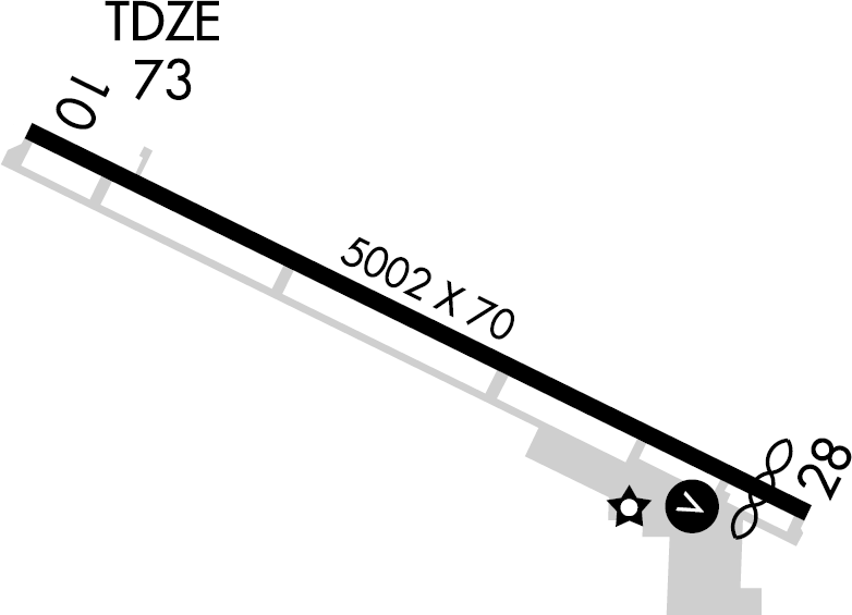
| Runways |
| Direction |
Length |
Surface |
| ft |
m |
| 10/28 |
5,002 |
1,525 |
Asphalt |
Bermuda Dunes Airport (IATA: UDD, ICAO: KUDD, FAA LID: UDD) is a public airport located 13 miles (21 km) east of Palm Springs, serving Riverside County, California, USA. This general aviation airport covers 94 acres (380,000 m) and has one runway. This airport is also the home of Desert West Aviation, a local flight school as well as Desert Jet, a local aircraft charter company recently named the preferred jet provider for the airport
Use
There is an average of 107 operations per day.
| Air Taxi |
GA Local |
GA Transient |
| 21 |
32 |
54 |
There are 137 aircraft based here.
| Single Engine |
Multi Engine |
Jet |
Helicopter |
| 102 |
22 |
10 |
3 |
The above content comes from Wikipedia and is published under free licenses – click here to read more.
Location
& QuickFacts
|
FAA
Information Effective: |
2006-06-08 |
|
Airport
Identifier: |
UDD |
|
Longitude/Latitude: |
116-16-29.3280W/33-44-54.3750N
-116.274813/33.748438 (Estimated) |
|
Elevation: |
73 ft / 22.25 m (Surveyed) |
|
Land: |
94 acres |
|
From
nearest city: |
13 nautical miles E of Palm Springs, CA |
|
Location: |
Riverside County, CA |
|
Magnetic Variation: |
14E (1980) |
Owner
& Manager
|
Ownership: |
Privately owned |
|
Owner: |
Bermuda Dunes Airport Corp |
|
Address: |
79-880 Avenue 42
Bermuda Dunes, CA 92203 |
|
Phone
number: |
760-345-2558 |
|
Manager: |
Mike Smith |
|
Address: |
79-880 Ave. 42
Bermuda Dunes, CA 92203 |
|
Phone number: |
760-345-2558 |
Airport
Operations and Facilities
|
Airport
Use: |
Open to public |
|
Wind
indicator: |
Yes |
|
Segmented
Circle: |
Yes |
|
Control
Tower: |
No |
|
Attendance
Schedule: |
ALL/SAT-THU/0600-2100,ALL/FRI/0600-2200 |
|
Lighting
Schedule: |
DUSK-DAWN
LIRL RY 10/28 VASI RY 28 ON UNTIL 2200; AFTER 2200 ACTVT
- CTAF.
RY 28 OPER CONTINUOUSLY. |
|
Beacon
Color: |
Clear-Green (lighted land airport) |
|
Landing
fee charge: |
Yes
LNDG FEE BASED ON ACFT TYPE/SIZE. |
|
Sectional
chart: |
Los Angeles |
|
Region: |
AWP - Western-Pacific |
|
Traffic
Pattern Alt: |
1000 ft |
|
Boundary
ARTCC: |
ZLA - Los Angeles |
|
Tie-in
FSS: |
RAL - Riverside |
|
FSS
on Airport: |
No |
|
FSS
Phone: |
951-351-3020 |
|
FSS
Toll Free: |
1-800-WX-BRIEF |
|
NOTAMs
Facility: |
RAL (NOTAM-d service avaliable) |
|
Federal Agreements: |
N |
Airport
Communications
|
CTAF: |
122.800 |
|
Unicom: |
122.800 |
Airport
Services
|
Fuel
available: |
100LLA
FUEL AVBL 0630-2030. |
|
Airframe
Repair: |
MAJOR |
|
Power
Plant Repair: |
MAJOR |
|
Bottled
Oxygen: |
HIGH |
|
Runway Information
Runway 10/28
|
Dimension: |
5002 x 70 ft / 1524.6 x 21.3 m |
|
Surface: |
ASPH, Good Condition |
|
Weight
Limit: |
Dual wheel: 70000 lbs. |
|
Edge
Lights: |
Low |
|
|
Runway 10 |
Runway 28 |
|
Longitude: |
116-16-55.9620W |
116-16-02.6510W |
|
Latitude: |
33-45-05.1210N |
33-44-43.5530N |
|
Elevation: |
73.00 ft |
45.00 ft |
|
Alignment: |
116 |
127 |
|
Traffic
Pattern: |
Left |
Left |
|
Markings: |
Non-precision instrument, Fair Condition |
Non-precision instrument, Fair Condition |
|
Crossing
Height: |
0.00 ft |
25.00 ft |
|
Displaced
threshold: |
0.00 ft |
300.00 ft |
|
VASI: |
|
2-box on left side |
|
Visual
Glide Angle: |
0.00� |
3.00� |
|
Runway
End Identifier: |
No |
Yes |
|
Touchdown
Lights: |
No |
No |
|
Obstruction: |
6 ft fence, 200.0 ft from runway, 125 ft left
of centerline
+6' FENCE 125'L. |
37 ft road, 750.0 ft from runway, 150 ft right
of centerline, 14:1 slope to clear
APCH RATIO 28:1 TO DSPLCD THR.
+6'
FENCE 125'R. |
|
Radio Navigation
Aids
|
ID |
Type |
Name |
Ch |
Freq |
Var |
Dist |
|
SJY |
NDB |
San Jacinto |
|
227.00 |
14E |
36.3 nm |
|
NXP |
TACAN |
Coyote |
063X |
|
14E |
33.5 nm |
|
HDF |
VOR |
Homeland |
|
113.40 |
14E |
45.5 nm |
|
TRM |
VORTAC |
Thermal |
109X |
116.20 |
13E |
9.2 nm |
|
PSP |
VORTAC |
Palm Springs |
102X |
115.50 |
13E |
10.6 nm |
|
TNP |
VORTAC |
Twentynine Palms |
089X |
114.20 |
15E |
33.4 nm |
|
JLI |
VORTAC |
Julian |
087X |
114.00 |
15E |
39.7 nm |
Remarks
- NO
AGRI FLIGHTS EXCP BY PPR ARPT MGR.
- FOR
NOISE ABATEMENT PROCEDURES CALL AMGR (760) 345-2558.
- ARPT
CLSD TO TURBINE POWERED ACFT 2300-0600 LCL.
- 30
FT TREE LINE 125 FT NORTH OF CENTERLINE RY 10/28.
- PARL
TWY CLSD ACFT WING SPAN GREATER THAN 65 FT.
Based Aircraft
|
Aircraft
based on field: |
137 |
|
Single
Engine Airplanes: |
102 |
|
Multi
Engine Airplanes: |
22 |
|
Jet Engine
Airplanes: |
10 |
|
Helicopters: |
3 |
Operational Statistics
|
Aircraft
Operations: |
121/Day |
|
Air Taxi: |
18.2% |
|
General
Aviation Local: |
27.3% |
|
General
Aviation Itinerant: |
54.5% |
|
Military: |
0.0% |
Bermuda Dunes Airport
Address:
Riverside County, CA
Tel:
760-345-2558
Images
and information placed above are from
http://www.airport-data.com/airport/UDD/
We
thank them for the data!
| General
Info |
| Country |
United
States |
| State |
CALIFORNIA
|
| FAA ID |
UDD
|
| Latitude |
33-44-54.375N
|
| Longitude |
116-16-29.328W
|
| Elevation |
73 feet
|
| Near City |
PALM SPRINGS
|
We don't guarantee the information is fresh and accurate. The data may
be wrong or outdated.
For more up-to-date information please refer to other sources.
|
|