 |
|
Coordinates: 40°34′27″N 122°24′27″W / 40.57417°N 122.4075°W / 40.57417; -122.4075
Benton Field
Benton Airpark |
| IATA: none – ICAO: none – FAA LID: O85 |
| Summary |
| Airport type |
Public |
| Owner |
City of Redding |
| Serves |
Redding, California |
| Elevation AMSL |
719 ft / 219 m |
| Runways |
| Direction |
Length |
Surface |
| ft |
m |
| 15/33 |
2,420 |
738 |
Asphalt |
| Statistics (2002) |
| Aircraft operations |
35,000 |
| Based aircraft |
122 |
| Sources: airport web site and FAA |
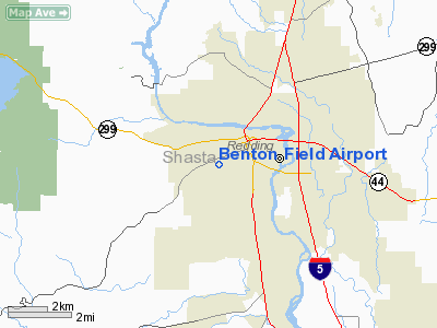
Benton Field (FAA LID: O85), also known as Benton Airpark, is a city-owned public-use airport located one mile (1.6 km) west of the central business district of Redding, a city in Shasta County, California, United States. It is one of two airports located in the City of Redding, the other being Redding Municipal Airport.
The airport is named for Lt. John W. Benton, a U.S. Army Air Corp pilot and a Shasta County resident who died in a flight at Buenos Aires in 1927.
Facilities and aircraft
Benton Field covers an area of 80 acres (32 ha) and contains one runway designated 15/33 with a 2,420 x 80 ft (738 x 24 m) asphalt surface. For the 12-month period ending December 31, 2002, the airport had 35,000 aircraft operations, an average of 95 per day: 97% general aviation and 3% air taxi. There are 122 aircraft based at this airport: 93% single-engine, 5% multi-engine and 2% helicopter. Benton Field also serves as the headquarters of the California Highway Patrol Northern Division Air Operations unit. The unit includes two single-engine CHP airplanes and two CHP helicopters based at the airpark.
The above content comes from Wikipedia and is published under free licenses – click here to read more.
Location
& QuickFacts
|
FAA
Information Effective: |
2006-06-08 |
|
Airport
Identifier: |
O85 |
|
Longitude/Latitude: |
122-24-29.0310W/40-34-29.5420N
-122.408064/40.574873 (Estimated) |
|
Elevation: |
719 ft / 219.15 m (Surveyed) |
|
Land: |
80 acres |
|
From
nearest city: |
1 nautical miles W of Redding, CA |
|
Location: |
Shasta County, CA |
|
Magnetic Variation: |
17E (1985) |
Owner
& Manager
|
Ownership: |
Publicly owned |
|
Owner: |
City Of Redding |
|
Address: |
777 Cypress Ave
Redding, CA 96001 |
|
Phone
number: |
530-224-4321 |
|
Manager: |
Rod Dinger |
|
Address: |
6751 Woodrum Circle, #200
Redding, CA 96002 |
|
Phone
number: |
530-224-4321
PHONE AT MGRS OFFICE AT REDDING MUNI ARPT; PHONE (530) 241-4204
FOR FBO ON FIELD. |
Airport
Operations and Facilities
|
Airport
Use: |
Open to public |
|
Wind
indicator: |
Yes |
|
Segmented
Circle: |
Yes |
|
Control
Tower: |
No |
|
Attendance
Schedule: |
ALL/ALL/0600-DUSK |
|
Lighting
Schedule: |
DUSK-DAWN
ACTVT MIRL RY 15/33 - CTAF. PAPI RY 15 AND RY 33 OPER CONTINUOUSLY. |
|
Beacon
Color: |
Clear-Green (lighted land airport) |
|
Landing
fee charge: |
No |
|
Sectional
chart: |
Klamath Falls |
|
Region: |
AWP - Western-Pacific |
|
Traffic
Pattern Alt: |
1000 ft |
|
Boundary
ARTCC: |
ZOA - Oakland |
|
Tie-in
FSS: |
RIU - Rancho Murieta |
|
FSS
on Airport: |
No |
|
FSS
Phone: |
916-354-0161 |
|
FSS
Toll Free: |
1-800-WX-BRIEF |
|
NOTAMs
Facility: |
RIU (NOTAM-d service avaliable) |
|
Federal
Agreements: |
NGY |
Airport
Communications
|
CTAF: |
122.800 |
|
Unicom: |
122.800 |
Airport
Services
|
Fuel
available: |
100LLA |
|
Airframe
Repair: |
MINOR |
|
Power
Plant Repair: |
MINOR |
|
Bottled
Oxygen: |
NONE |
|
Bulk
Oxygen: |
NONE
HI & LO PRESSURE & OX REPL BOTTLES AVBL IN REDDING. |
|
Runway Information
Runway 15/33
|
Dimension: |
2420 x 80 ft / 737.6 x 24.4 m |
|
Surface: |
ASPH, Fair Condition |
|
Weight
Limit: |
Single wheel: 12500 lbs. |
|
Edge
Lights: |
Medium |
|
|
Runway 15 |
Runway 33 |
|
Elevation: |
719.00 ft |
715.00 ft |
|
Traffic
Pattern: |
Right |
Left |
|
Markings: |
Basic, Fair Condition |
Basic, Fair Condition |
|
Crossing
Height: |
40.00 ft |
40.00 ft |
|
VASI: |
2-light PAPI on left side |
2-light PAPI on left side |
|
Visual
Glide Angle: |
3.50� |
3.50� |
|
Runway
End Identifier: |
No |
No |
|
Centerline
Lights: |
No |
No |
|
Touchdown
Lights: |
No |
No |
|
Obstruction: |
15 ft trees, 580.0 ft from runway, 105 ft right
of centerline, 25:1 slope to clear |
45 ft tree, 1390.0 ft from runway, 135 ft left
of centerline, 26:1 slope to clear |
|
Radio Navigation
Aids
|
ID |
Type |
Name |
Ch |
Freq |
Var |
Dist |
|
PBT |
NDB |
Proberta |
|
338.00 |
16E |
28.8 nm |
|
RDD |
VOR/DME |
Redding |
021X |
108.40 |
18E |
6.8 nm |
|
RBL |
VORTAC |
Red Bluff |
104X |
115.70 |
18E |
29.7 nm |
Remarks
- STEEP
BLUFF 100' FROM EACH RWY END.
- LARGE
BIRDS FREQUENTLY ON AND IN VICINITY OF ARPT OCT-APR.
- RWY
15/33 HALFWAY DIST. MARKERS BOTH SIDES OF RWY.
- FOR
NOISE ABATEMENT CLIMB TO 1281 FT AGL BEFORE TURNING.
- RY
15/33 SAFETY AREAS NSTD LENGTH; EACH SAFETY AREA 100 FT.
- RY
15/33 THLD LGTS ARE NSTD, BEING 13 FT SHORT OF THE RY THLD.
- ESTABD
PRIOR TO 15 MAY 1959.
Based Aircraft
|
Aircraft
based on field: |
122 |
|
Single
Engine Airplanes: |
113 |
|
Multi
Engine Airplanes: |
6 |
|
Helicopters: |
3 |
Operational Statistics
|
Aircraft
Operations: |
96/Day |
|
Air Taxi: |
2.9% |
|
General
Aviation Local: |
48.6% |
|
General
Aviation Itinerant: |
48.6% |
Benton Field Airport
Address:
Shasta County, CA
Tel:
530-224-4321
Images
and information placed above are from
http://www.airport-data.com/airport/O85/
We
thank them for the data!
| General
Info |
| Country |
United
States |
| State |
CALIFORNIA
|
| FAA ID |
O85
|
| Latitude |
40-34-29.542N
|
| Longitude |
122-24-29.031W
|
| Elevation |
719 feet
|
| Near City |
REDDING
|
We don't guarantee the information is fresh and accurate. The data may
be wrong or outdated.
For more up-to-date information please refer to other sources.
|
|


