 |
|
Banning Municipal Airport |
| Banning Municipal Airport |
| IATA: BNG – ICAO: KBNG – FAA LID: BNG |
| Summary |
| Airport type |
Public |
| Owner |
City of Banning |
| Serves |
Banning, California |
| Elevation AMSL |
2,219 ft / 676 m |
| Coordinates |
33°55′21″N 116°51′02″W / 33.9225°N 116.85056°W / 33.9225; -116.85056 |
| Runways |
| Direction |
Length |
Surface |
| ft |
m |
| 8/26 |
5,200 |
1,585 |
Asphalt |
| Statistics (2010) |
| Aircraft operations |
9,450 |
| Based aircraft |
40 |
| Source: Federal Aviation Administration |
Banning Municipal Airport (IATA: BNG, ICAO: KBNG, FAA LID: BNG) is a city-owned public-use airport located one nautical mile (1.85 km) southeast of the central business district of Banning, a city in Riverside County, California, United States. The airport is mostly used for general aviation.
Facilities and aircraft
Banning Municipal Airport covers an area of 141 acres (57 ha) at an elevation of 2,219 feet (676 m) above mean sea level. It has one runway designated 8/26 with an asphalt surface measuring 5,200 by 150 feet (1,585 x 46 m).
For the 12-month period ending February 10, 2010, the airport had 9,450 general aviation aircraft operations, an average of 25 per day. At that time there were 40 aircraft based at this airport: 100% single-engine.
The above content comes from Wikipedia and is published under free licenses – click here to read more.
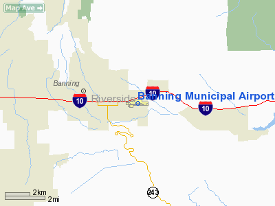
Location
& QuickFacts
|
FAA
Information Effective: |
2006-06-08 |
|
Airport
Identifier: |
BNG |
|
Longitude/Latitude: |
116-51-02.0720W/33-55-23.0560N
-116.850576/33.923071 (Estimated) |
|
Elevation: |
2219 ft / 676.35 m (Surveyed) |
|
Land: |
141 acres |
|
From
nearest city: |
1 nautical miles SE of Banning, CA |
|
Location: |
Riverside County, CA |
|
Magnetic Variation: |
14E (1985) |
Owner
& Manager
|
Ownership: |
Publicly owned |
|
Owner: |
City Of Banning |
|
Address: |
P.o. Box 998
Banning, CA 92220 |
|
Phone
number: |
951-922-3130 |
|
Manager: |
Kahono Oei - City Engineer |
|
Address: |
P.o. Box 998
Banning, CA 92220 |
|
Phone number: |
951-922-3130 |
Airport
Operations and Facilities
|
Airport
Use: |
Open to public |
|
Wind
indicator: |
Yes |
|
Segmented
Circle: |
Yes |
|
Control
Tower: |
No |
|
Attendance
Schedule: |
ALL/ALL/0800-1700
FOR ARPT ATTENDANT CALL (951) 922-3320. |
|
Lighting
Schedule: |
DUSK-DAWN
ACTVT MIRL RY 08/26 - CTAF. |
|
Beacon
Color: |
Clear-Green (lighted land airport) |
|
Landing
fee charge: |
No |
|
Sectional
chart: |
Los Angeles |
|
Region: |
AWP - Western-Pacific |
|
Traffic
Pattern Alt: |
1000 ft |
|
Boundary
ARTCC: |
ZLA - Los Angeles |
|
Tie-in
FSS: |
RAL - Riverside |
|
FSS
on Airport: |
No |
|
FSS
Phone: |
951-351-3020 |
|
FSS
Toll Free: |
1-800-WX-BRIEF |
|
NOTAMs
Facility: |
RAL (NOTAM-d service avaliable) |
|
Federal Agreements: |
NGY |
Airport
Communications
|
CTAF: |
122.800 |
|
Unicom: |
122.800 |
Airport
Services
|
Fuel
available: |
100LL |
|
Airframe
Repair: |
NONE |
|
Power
Plant Repair: |
NONE |
|
Bottled
Oxygen: |
NONE |
|
Bulk
Oxygen: |
NONE |
|
Runway Information
Runway 08/26
|
Dimension: |
5200 x 150 ft / 1585.0 x 45.7 m |
|
Surface: |
ASPH, Good Condition |
|
Weight
Limit: |
Single wheel: 12500 lbs. |
|
Edge
Lights: |
Medium |
|
|
Runway 08 |
Runway 26 |
|
Traffic
Pattern: |
Left |
Right |
|
Markings: |
Basic, Fair Condition |
Basic, Fair Condition |
|
Displaced
threshold: |
0.00 ft |
230.00 ft |
|
VASI: |
|
2-light PAPI on left side |
|
Visual
Glide Angle: |
0.00� |
3.50� |
|
Obstruction: |
55 ft pole, 2650.0 ft from runway, 44:1 slope
to clear |
, 50:1 slope to clear
APCH RATIO 50:1 TO DSPLCD THLD.
+3' FENCE 100' FM THR PERPENDICULAR TO CNTRLN. |
|
Radio Navigation
Aids
|
ID |
Type |
Name |
Ch |
Freq |
Var |
Dist |
|
SJY |
NDB |
San Jacinto |
|
227.00 |
14E |
10.7 nm |
|
SB |
NDB |
Petis |
|
397.00 |
14E |
26.9 nm |
|
RIV |
TACAN |
March |
077X |
|
14E |
21.2 nm |
|
NXP |
TACAN |
Coyote |
063X |
|
14E |
41.2 nm |
|
NFG |
TACAN |
Camp Pendleton |
055X |
|
13E |
47.3 nm |
|
HDF |
VOR |
Homeland |
|
113.40 |
14E |
18.9 nm |
|
RAL |
VOR |
Riverside |
|
112.40 |
15E |
29.9 nm |
|
ELB |
VOR/DME |
El Toro |
119X |
117.20 |
14E |
46.4 nm |
|
VCV |
VOR/DME |
Victorville |
031X |
109.40 |
14E |
48.4 nm |
|
PSP |
VORTAC |
Palm Springs |
102X |
115.50 |
13E |
21.2 nm |
|
PDZ |
VORTAC |
Paradise |
059X |
112.20 |
15E |
33.9 nm |
|
TRM |
VORTAC |
Thermal |
109X |
116.20 |
13E |
38.8 nm |
|
POM |
VORTAC |
Pomona |
041X |
110.40 |
15E |
47.6 nm |
|
JLI |
VORTAC |
Julian |
087X |
114.00 |
15E |
48.9 nm |
|
OCN |
VORTAC |
Oceanside |
100X |
115.30 |
15E |
49.9 nm |
Remarks
- NO
INTERSECTION TAKEOFFS TO THE WEST.
- RY
08/26 NO STRAIGHT-IN LANDINGS.
- RWY
26 AFTER TAKEOFF AVOID OVERFLYING HOUSES 4 MILES WEST.
Based Aircraft
|
Aircraft
based on field: |
74 |
|
Single
Engine Airplanes: |
70 |
|
Multi
Engine Airplanes: |
3 |
|
Helicopters: |
1 |
Operational Statistics
|
Aircraft
Operations: |
202/Week |
|
General
Aviation Local: |
28.6% |
|
General
Aviation Itinerant: |
71.4% |
Banning Municipal Airport
Address:
Riverside County, CA
Tel:
951-922-3130
Images
and information placed above are from
http://www.airport-data.com/airport/BNG/
We
thank them for the data!
| General
Info |
| Country |
United
States |
| State |
CALIFORNIA
|
| FAA ID |
BNG
|
| Latitude |
33-55-23.056N
|
| Longitude |
116-51-02.072W
|
| Elevation |
2219 feet
|
| Near City |
BANNING
|
We don't guarantee the information is fresh and accurate. The data may
be wrong or outdated.
For more up-to-date information please refer to other sources.
|
|


