|
|
| Arcata/Eureka Airport |
 |
| IATA: ACV – ICAO: KACV – FAA LID: ACV |
| Summary |
| Airport type |
Public |
| Operator |
Humboldt County |
| Serves |
Arcata, California and Eureka, California |
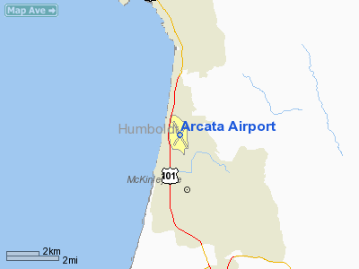
| Location |
McKinleyville, California |
| Elevation AMSL |
221 ft / 67 m |
| Coordinates |
40°58′41″N 124°06′31″W / 40.97806°N 124.10861°W / 40.97806; -124.10861 |
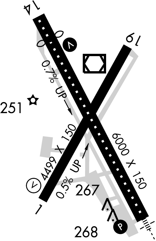
| Runways |
| Direction |
Length |
Surface |
| ft |
m |
| 1/19 |
4,499 |
1,371 |
Asphalt |
| 14/32 |
6,000 |
1,829 |
Asphalt |
Arcata/Eureka Airport (IATA: ACV, ICAO: KACV, FAA LID: ACV), also known as Arcata Airport, is an airport located 15 miles (24 km) north of Eureka in the unincorporated town of McKinleyville, California. This regional airport serves Humboldt County, including the two primary regional cities that compose its name: Arcata and Eureka. The airport is a Federally designated port of entry for civil aircraft arriving in the United States. History
The airport was originally constructed by the United States Navy during World War II for the purpose of testing defogging systems for aircraft. In December 1947 a Southwest Airways DC-3 flying into the airport made the world's first blind landing on a scheduled commercial airliner using Ground-Controlled Approach (GCA) radar, Instrument Landing System (ILS) devices and Fog Investigation and Dispersal Operation (FIDO) oil-burning units adjacent to the runway. By the following year the airline had made 1,200 routine instrument landings at the often fog-shrouded airport.
For the year of 2005, the Arcata-Eureka Airport serviced 102,000 arriving commercial passengers and 104,000 departing on 4,370 departing flights. Horizon carried 66.29% of the passengers with United carrying the remainder. 78% of the 2005 flights departed on time and 79% of the arriving flights were on time. In addition to passenger traffic, the airport also shipped 457,000 pounds (207,291 kg) of cargo.
Current utilization is now a mixture of general and commercial aviation with two commercial airlines providing scheduled service: United Express operated by SkyWest Airlines, and Horizon Air.
Facilities
The Arcata-Eureka Airport covers 745 acres (301 ha) and has two runways:
- Runway 1/19: 4,499 x 150 ft. (1,371 x 46 m), Surface: Asphalt
- Runway 14/32: 6,000 x 150 ft. (1,829 x 46 m), Surface: Asphalt
Being located on the Pacific coast of California, the airport falls under the jurisdiction of the California Coastal Commission and major changes to the airport such as rezoning or fencing in the airport require approval by the Commission.
The approach flight path for runway 32 passes over Central Avenue, a highly travelled road in the area. The strobe lights that direct planes onto the runway were creating a visual hazard for drivers on Central Avenue as the strobe lights were creating a glare. The problem was especially noticeable during inclement weather when the strobes' intensity was increased and the roadways were reflective from water on the surface. The Federal Aviation Administration's Office of Aviation Research, Airport Technology Research and Development Branch responded to the hazard by installing baffles on the strobes that block the lights from shining on the road while still providing visual guidance for aircraft.
Airlines and destinations
| Airlines |
Destinations |
| Horizon Air |
Los Angeles, Redding |
| United Express operated by SkyWest Airlines |
Crescent City, Sacramento, San Francisco |
Ground transportation
- Airport transit bus stop times - service by Redwood Transit System
- For taxi and rental car information, see Humboldt County Convention and Visitor's Bureau page
Other local airports
- Eureka Municipal Airport (California)
- Kneeland Airport - located ten miles (16 km) southeast of Eureka
- Murray Field - located in Eureka
The above content comes from Wikipedia and is published under free licenses – click here to read more.
Location
& QuickFacts
|
FAA
Information Effective: |
2006-06-08 |
|
Airport
Identifier: |
ACV |
|
Longitude/Latitude: |
124-06-31.0000W/40-58-41.2000N
-124.108611/40.978111 (Estimated) |
|
Elevation: |
221 ft / 67.36 m (Surveyed) |
|
Land: |
745 acres |
|
From
nearest city: |
7 nautical miles N of Arcata/eureka, CA |
|
Location: |
Humboldt County, CA |
|
Magnetic Variation: |
17E (1985) |
Owner
& Manager
|
Ownership: |
Publicly owned |
|
Owner: |
Humboldt County |
|
Address: |
1106 Second St
Eureka, CA 95501 |
|
Phone
number: |
707-445-7491 |
|
Manager: |
Jacquelyn Hulsey |
|
Address: |
3561 Boeing Ave.
Mckinleyville, CA 95519 |
|
Phone number: |
707-839-5401 |
Airport
Operations and Facilities
|
Airport
Use: |
Open to public |
|
Wind
indicator: |
Yes |
|
Segmented
Circle: |
Yes |
|
Control
Tower: |
No |
|
Attendance
Schedule: |
ALL/SUN-FRI/0600-2300,ALL/SAT/0700-1800 |
|
Lighting
Schedule: |
DUSK-DAWN
ACTVT HIRL RY 14/32; RY 14 REIL AND VASI; RY 32 MALSR; TDZL
AND PAPI - CTAF. |
|
Beacon
Color: |
Clear-Green (lighted land airport) |
|
Landing
fee charge: |
No |
|
Sectional
chart: |
Klamath Falls |
|
Region: |
AWP - Western-Pacific |
|
Boundary
ARTCC: |
ZSE - Seattle |
|
Tie-in
FSS: |
OAK - Oakland |
|
FSS
on Airport: |
No |
|
FSS
Phone: |
510-273-6111 |
|
FSS
Toll Free: |
1-800-WX-BRIEF |
|
NOTAMs
Facility: |
ACV (NOTAM-d service avaliable) |
|
Certification
type/date: |
I AS 5/1973
CLSD TO UNSKED ACR OPS WITH MORE THAN 30 PSGR SEATS EXCEPT
PPR CALL AMGR 707-839-5402. |
|
Federal Agreements: |
NGPY |
Airport
Communications
|
CTAF: |
123.000 |
|
Unicom: |
123.000 |
Airport
Services
|
Fuel
available: |
100LLA
FUEL AVBL 0400-2400 LOCAL. |
|
Bottled
Oxygen: |
NONE |
|
Runway Information
Runway 01/19
|
Dimension: |
4499 x 150 ft / 1371.3 x 45.7 m |
|
Surface: |
ASPH, Good Condition |
|
Surface
Treatment: |
Saw-cut or plastic Grooved |
|
Weight
Limit: |
Single wheel: 60000 lbs.
Dual wheel: 95000 lbs.
Dual
tandem wheel: 170000 lbs. |
|
Edge
Lights: |
Medium
MIRL OTS INDEFLY. |
|
|
Runway 01 |
Runway 19 |
|
Longitude: |
124-06-46.5093W |
124-06-17.4129W |
|
Latitude: |
40-58-20.8500N |
40-58-59.4438N |
|
Elevation: |
188.00 ft |
208.00 ft |
|
Alignment: |
30 |
127 |
|
Traffic
Pattern: |
Left |
Right |
|
Markings: |
Non-precision instrument, Good Condition |
Non-precision instrument, Good Condition |
|
Crossing
Height: |
40.00 ft |
0.00 ft |
|
VASI: |
4-box on left side
VASI OTS INDEFLY. |
|
|
Visual
Glide Angle: |
3.00� |
0.00� |
|
Runway
End Identifier: |
Yes
REIL OTS INDEFLY. |
No |
|
Centerline
Lights: |
No |
No |
|
Touchdown
Lights: |
No |
No |
|
Obstruction: |
|
142 ft trees, 3450.0 ft from runway, 23:1 slope
to clear |
|
Runway 14/32
|
Dimension: |
6000 x 150 ft / 1828.8 x 45.7 m |
|
Surface: |
ASPH, Good Condition |
|
Surface
Treatment: |
Saw-cut or plastic Grooved |
|
Weight
Limit: |
Single wheel: 60000 lbs.
Dual wheel: 155000 lbs.
Dual tandem wheel: 280000 lbs. |
|
Edge
Lights: |
High
MIRL OTS INDEFLY. |
|
|
Runway 14 |
Runway 32 |
|
Longitude: |
124-06-48.1647W |
124-06-12.3409W |
|
Latitude: |
40-59-08.3568N |
40-58-15.6612N |
|
Elevation: |
182.00 ft |
221.00 ft |
|
Alignment: |
127 |
127 |
|
ILS
Type: |
|
ILS/DME |
|
Traffic
Pattern: |
Right |
Left |
|
Markings: |
Precision instrument, |
Precision instrument, |
|
Crossing
Height: |
51.00 ft |
46.00 ft |
|
Displaced
threshold: |
797.00 ft |
0.00 ft |
|
VASI: |
12-box on both sides |
4-light PAPI on left side |
|
Visual
Glide Angle: |
2.80� |
3.00� |
|
RVR
Equipment: |
|
touchdown, rollout |
|
Approach
lights: |
|
MALSR |
|
Runway
End Identifier: |
Yes |
Yes |
|
Centerline
Lights: |
Yes |
Yes |
|
Touchdown
Lights: |
No |
Yes |
|
Obstruction: |
, 50:1 slope to clear |
91 ft tree, 2625.0 ft from runway, 875 ft right
of centerline, 26:1 slope to clear |
|
Decleard
distances: |
Take off run available 5998.00 ft
Take off distance available 5998.00 ft
Actual stop distance available 5998.00 ft
Landing distance available 5198.00 ft |
Take off run available 5998.00 ft
Take off distance available 5998.00 ft
Actual stop distance available 5198.00 ft
Landing distance available 5198.00 ft |
|
Radio Navigation
Aids
|
ID |
Type |
Name |
Ch |
Freq |
Var |
Dist |
|
ACV |
VOR/DME |
Arcata |
039X |
110.20 |
17E |
0.2 nm |
|
FOT |
VORTAC |
Fortuna |
087X |
114.00 |
19E |
19.3 nm |
|
CEC |
VORTAC |
Crescent City |
027X |
109.00 |
19E |
48.5 nm |
Remarks
Based Aircraft
|
Aircraft
based on field: |
12 |
|
Single
Engine Airplanes: |
2 |
|
Multi
Engine Airplanes: |
2 |
|
Jet Engine
Airplanes: |
2 |
|
Helicopters: |
4 |
|
Military: |
2 |
Major Carriers
Serving This Airport
Most Popular Destinations
| San Francisco International (SFO) |
67.8% |
| Sacramento International (SMF) |
16.2% |
|
Jack Mc Namara Field (CEC) |
16.1% |
Most Popular Aircraft
|
N292SW |
6.0% |
| N218SW |
4.2% |
|
N290SW |
3.8% |
| N581SW |
3.7% |
|
N270YV |
3.4% |
| N229SW |
3.1% |
|
N251YV |
2.9% |
| N284YV |
2.9% |
|
N294SW |
2.8% |
| N296SW |
2.6% |
Operational Statistics
|
Aircraft
Operations: |
116/Day |
|
Air Taxi: |
28.9% |
|
General
Aviation Local: |
5.5% |
|
General
Aviation Itinerant: |
6.2% |
|
Military: |
59.5% |
Arcata Airport
Address:
Humboldt County, CA
Tel:
707-445-7491,
707-839-5401
Images
and information placed above are from
http://www.airport-data.com/airport/ACV/
We
thank them for the data!
| General
Info |
| Country |
United
States |
| State |
CALIFORNIA
|
| FAA ID |
ACV
|
| Latitude |
40-58-41.215N
|
| Longitude |
124-06-31.028W
|
| Elevation |
218 feet
|
| Near City |
ARCATA/EUREKA
|
We don't guarantee the information is fresh and accurate. The data may
be wrong or outdated.
For more up-to-date information please refer to other sources.
|
|