|
|
Alturas Municipal Airport |
| Alturas Municipal Airport |
 |
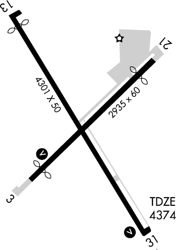
| FAA runway diagram |
| IATA: none – ICAO: KAAT – FAA LID: AAT |
| Summary |
| Airport type |
Public |
| Owner |
City of Alturas |
| Serves |
Alturas, California |
| Elevation AMSL |
4,378 ft / 1,334 m |
| Coordinates |
41°28′59″N 120°33′55″W / 41.48306°N 120.56528°W / 41.48306; -120.56528 |
| Runways |
| Direction |
Length |
Surface |
| ft |
m |
| 13/31 |
4,300 |
1,311 |
Asphalt |
| 3/21 |
3,096 |
944 |
Asphalt |
| Statistics (2008) |
| Aircraft operations |
31,500 |
| Source: Federal Aviation Administration |
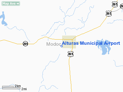
Alturas Municipal Airport (ICAO: KAAT, FAA LID: AAT formerly O00), is a city-owned public-use airport located one nautical mile (1.85 km) west of the central business district of Alturas, a city in Modoc County, California, United States. This airport is included in the FAA's National Plan of Integrated Airport Systems for 2009–2013, which categorizes it as a general aviation facility.
Although most U.S. airports use the same three-letter location identifier for the FAA and IATA, this airport is assigned AAT by the FAA but has no designation from the IATA (which assigned AAT to Altay Airport in Altay, Xinjiang, China).
Facilities and aircraft
Alturas Municipal Airport covers an area of 160 acres (65 ha) at an elevation of 4,378 feet (1,334 m) above mean sea level. It has two asphalt paved runways: 13/31 is 4,300 by 50 feet (1,311 x 15 m) and 3/21 is 3,096 by 60 feet (944 x 18 m). For the 12-month period ending December 31, 2008, the airport had 31,500 aircraft operations, an average of 86 per day: 95% general aviation and 5% air taxi.
The above content comes from Wikipedia and is published under free licenses – click here to read more.
Location
& QuickFacts
|
FAA
Information Effective: |
2006-06-08 |
|
Airport
Identifier: |
AAT |
|
Longitude/Latitude: |
120-33-55.3000W/41-28-58.8000N
-120.565361/41.483000 (Estimated) |
|
Elevation: |
4374 ft / 1333.20 m (Surveyed) |
|
Land: |
160 acres |
|
From
nearest city: |
1 nautical miles W of Alturas, CA |
|
Location: |
Modoc County, CA |
|
Magnetic Variation: |
16E (1985) |
Owner
& Manager
|
Ownership: |
Publicly owned |
|
Owner: |
City Of Alturas
OPERD BY COUNTY OF MODOC. |
|
Address: |
Modoc Co Dpw 202 W 4th St
Alturas, CA 96101 |
|
Phone
number: |
530-233-4403 |
|
Manager: |
Rick Hironymous
CELL: 530-640-1122 |
|
Address: |
202 W 4th St
Alturas, CA 96101 |
|
Phone
number: |
530-233-6403
PUBLIC WORKS IN ALTURAS. FBO AT ARPT 916-233-5125. |
Airport
Operations and Facilities
|
Airport
Use: |
Open to public |
|
Wind
indicator: |
Yes |
|
Segmented
Circle: |
Yes |
|
Control
Tower: |
No |
|
Attendance
Schedule: |
ALL/ALL/0800-1700 |
|
Lighting
Schedule: |
DUSK-DAWN
ACTVT MIRL RY 13/31; LIRL RY 03/21; VASI & REIL RYS
03 & 31 - CTAF. |
|
Beacon
Color: |
Clear-Green (lighted land airport) |
|
Landing
fee charge: |
No |
|
Sectional
chart: |
Klamath Falls |
|
Region: |
AWP - Western-Pacific |
|
Traffic
Pattern Alt: |
1000 ft |
|
Boundary
ARTCC: |
ZSE - Seattle |
|
Tie-in
FSS: |
RNO - Reno |
|
FSS
on Airport: |
No |
|
FSS
Phone: |
775-858-1300 |
|
FSS
Toll Free: |
1-800-WX-BRIEF |
|
NOTAMs
Facility: |
AAT (NOTAM-d service avaliable) |
|
Federal Agreements: |
NGY |
Airport
Communications
|
CTAF: |
122.800 |
|
Unicom: |
122.800 |
Airport
Services
|
Fuel
available: |
100LLA |
|
Airframe
Repair: |
MAJOR |
|
Power
Plant Repair: |
MAJOR |
|
Runway Information
Runway 03/21
|
Dimension: |
2935 x 60 ft / 894.6 x 18.3 m |
|
Surface: |
ASPH, Good Condition |
|
Weight
Limit: |
Single wheel: 12000 lbs.
GROSS PAVEMENT STRENGTH PROVIDED BY AIRPORT MANAGER. |
|
Edge
Lights: |
Low |
|
|
Runway 03 |
Runway 21 |
|
Longitude: |
120-34-07.4294W |
120-33-39.5920W |
|
Latitude: |
41-28-49.8360N |
41-29-09.8886N |
|
Elevation: |
4359.00 ft |
4374.00 ft |
|
Alignment: |
46 |
127 |
|
Traffic
Pattern: |
Left |
Right |
|
Markings: |
Basic, Good Condition |
Basic, Good Condition |
|
Crossing
Height: |
28.00 ft |
0.00 ft |
|
Displaced
threshold: |
280.00 ft |
330.00 ft |
|
VASI: |
4-box on left side |
|
|
Visual
Glide Angle: |
3.00� |
0.00� |
|
Runway
End Identifier: |
Yes |
No |
|
Centerline
Lights: |
No |
No |
|
Touchdown
Lights: |
No |
No |
|
Obstruction: |
26 ft rr, 500.0 ft from runway, 125 ft right
of centerline, 11:1 slope to clear
APCH RATIO 20:1 FM DSPLCD OVER +26' RR 545'. |
38 ft tree, 250.0 ft from runway, 175 ft left
of centerline, 1:1 slope to clear
RWY 21 APCH RATIO 15:1 FM DSPLCD THLD. |
|
Runway 13/31
|
Dimension: |
4301 x 50 ft / 1310.9 x 15.2 m |
|
Surface: |
ASPH, Good Condition |
|
Weight
Limit: |
Single wheel: 12000 lbs.
GROSS PAVEMENT STRENGTH PROVIDED BY AIRPORT MANAGER. |
|
Edge
Lights: |
Medium |
|
|
Runway 13 |
Runway 31 |
|
Longitude: |
120-34-11.3110W |
120-33-41.6670W |
|
Latitude: |
41-29-16.1230N |
41-28-39.9600N |
|
Elevation: |
4366.00 ft |
4374.00 ft |
|
Alignment: |
127 |
127 |
|
Traffic
Pattern: |
Right |
Left |
|
Markings: |
Non-precision instrument, Good Condition |
Non-precision instrument, Good Condition |
|
Crossing
Height: |
0.00 ft |
28.00 ft |
|
Displaced
threshold: |
210.00 ft |
0.00 ft |
|
VASI: |
|
4-box on left side |
|
Visual
Glide Angle: |
0.00� |
3.00� |
|
Runway
End Identifier: |
No |
Yes |
|
Centerline
Lights: |
No |
No |
|
Touchdown
Lights: |
No |
No |
|
Obstruction: |
16 ft road, 300.0 ft from runway, 150 ft left
of centerline, 6:1 slope to clear
RWY 13 APCH RATIO 20:1 FM DSPLCD THR. |
12 ft rr, 340.0 ft from runway, 125 ft left
of centerline, 11:1 slope to clear |
|
Radio Navigation
Aids
|
ID |
Type |
Name |
Ch |
Freq |
Var |
Dist |
|
ARU |
NDB |
Alturas |
|
215.00 |
18E |
0.8 nm |
Remarks
-
< OVER
ALT MIN 150? COND. WIND ADVERSE DURG EXCP NE TKOF>
- WILDLIFE
REFUGES TO THE SW; SOUTH AND SE PRESENT POTENTIAL BIRD HAZARDS TO ACFT
FROM OCT THRU APR.
- ESTABD
PRIOR TO 15 MAY 1959.
Based Aircraft
|
Aircraft
based on field: |
12 |
|
Single
Engine Airplanes: |
11 |
|
Multi
Engine Airplanes: |
1 |
Operational Statistics
|
Aircraft
Operations: |
87/Day |
|
Air Taxi: |
4.8% |
|
General
Aviation Local: |
31.7% |
|
General
Aviation Itinerant: |
63.5% |
Alturas Municipal Airport
Address:
Modoc County, CA
Tel:
530-233-4403,
530-233-6403
Images
and information placed above are from
http://www.airport-data.com/airport/AAT/
We
thank them for the data!
| General
Info |
| Country |
United
States |
| State |
CALIFORNIA
|
| FAA ID |
AAT
|
| Latitude |
41-28-58.800N
|
| Longitude |
120-33-55.300W
|
| Elevation |
4374 feet
|
| Near City |
ALTURAS
|
We don't guarantee the information is fresh and accurate. The data may
be wrong or outdated.
For more up-to-date information please refer to other sources.
|
|