|
 |
|
||||
|
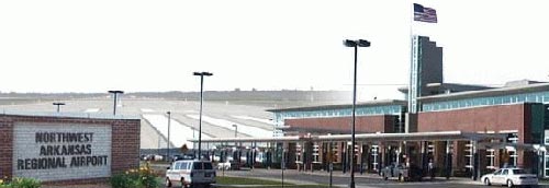
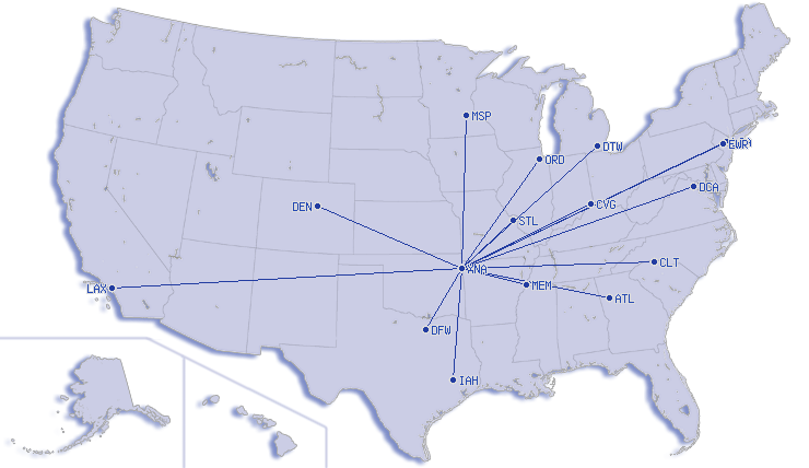
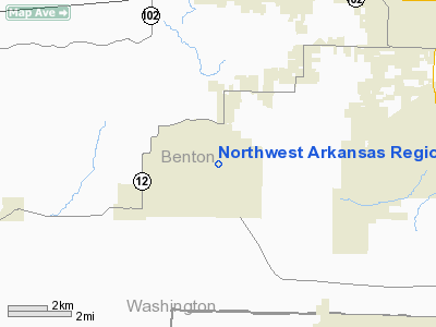
Northwest Arkansas Regional Airport (IATA: XNA, ICAO: KXNA, FAA LID: XNA) is an airport located in Highfill, Arkansas, near Bentonville, Rogers, Fayetteville, Springdale, and Siloam Springs, Arkansas. It is commonly referred to by its IATA code, which is incorporated in the airport's logo as "Fly XNA". XNA opened in November 1998 as a replacement airport for commercial traffic previously served by Fayetteville's aging and inadequate Drake Field, which was undersized to serve the rapidly-growing Northwest Arkansas region. American Airlines is the major carrier, serving 6 cities from XNA. Much of AA's expansion at XNA is due to its contract with Wal-Mart, which is based in Bentonville. ExpansionDue to rapid growth in Northwest Arkansas, in 2007 airport officials announced the construction of a new concourse costing between $20-$25 million. The new concourse would go east of the upper concourse, allowing the airport to park six to eight additional planes for boarding. The airport currently has 12 airplane parking positions. It will take about three years to complete. The airport recently completed a ticket counter expansion, and is planning two large warehouse additions. The airport has started a $30 million expansion to the upper-level concourse. The addition will add 51,000 square feet (4,700 m) and 7-8 upper level gates to the east side of the airport. Facilities and aircraftNorthwest Arkansas Regional Airport covers an area of 2,184 acres (884 ha) at an elevation of 1,287 feet (392 m) above mean sea level. It has one runway designated 16/34 with a concrete surface measuring 8,800 by 150 feet (2,682 x 46 m). For the 12-month period ending August 30, 2007, the airport had 55,028 aircraft operations, an average of 150 per day: 46% air taxi, 26% military, 15% general aviation and 13% scheduled commercial. Statistics
Airlines
The above content comes from Wikipedia and is published under free licenses – click here to read more.
About the Airport
Our mission is to ensure that the safest and most modern aviation infrastructure is in place to satisfy the needs of the traveling public. Environmentally conscious travel and development will be used to protect the natural splendor of the region while providing reliable, cost effective and convenient transportation for the public we serve.
History Overview With Air Force One in the background and a crowd of about 8,000 people looking on, President Bill Clinton dedicated the new Northwest Arkansas Regional Airport on November 6, 1998. The airport officially opened for commercial service on November 1, bringing to an end an eight-year process of planning and construction. A few days later, President Clinton headed a delegation of regional, state and federal officials who celebrated the opening of the country's third new commercial service airport in 25 years. (The other two are Dallas-Fort Worth and Denver.) "Today, in a sentence, at long last, Northwest Arkansas can fly," Mr. Clinton said. He added, "To me, this symbolizes America at its best. People working on a common goal, across party lines, putting people first, thinking about the future." Efforts to build a new regional airport in Northwest Arkansas date back to the 1950s. The earlier efforts weren't successful. The final effort began with a telephone call from the late Sam Walton, founder of Wal-Mart Stores, Inc., to then-Congressman John Paul Hammerschmidt. Mr. Walton and Rep. Hammerschmidt discussed the steps that would need to be taken to evaluate the possible construction of a new airport. In 1990, the Northwest Arkansas Council, a private, non-profit, organization was formed and Ms. Alice L. Walton was elected as its first chairperson. Under Ms. Walton's leadership and direction, the Council launched the effort that led to the creation of the Northwest Arkansas Regional Airport Authority. The cities of Bentonville, Fayetteville, Rogers, Siloam Springs, and Springdale, along with Benton and Washington Counties, created the Airport Authority as a separate public entity to investigate the feasibility of building a new regional airport. In 1992, the voters of all seven governmental entities voted overwhelmingly in favor of continuing their representation in the airport project. Over the next several years a series of studies concluded that a new airport was economically feasible and environmentally compatible. In 1994, the federal grant was awarded by the Federal Aviation Administration to purchase the land, and ground was broken and construction began in August of 1995. Three years and three months later XNA opened for commercial air service. American Eagle inaugurated its direct service from the regional airport to Chicago's O'Hare Airport on the airline's new regional jets. The airline also provides service from the regional airport to Dallas-Fort Worth. In January, 1999, TransWorld Express began providing service from the regional airport to St. Louis. In March, 1999, Atlantic Southeast Airlines, the Delta Connection partner, began providing service from the regional airport to Atlanta and DFW, and Northwest Airlines began providing service to Memphis. With the move of US Air in September of 1999, all commercial service for Northwest Arkansas was at the regional airport. Initially, the Authority had projected enplanements of about 200,000 for 1999. But the quicker-than-expected relocation of service to the new airport and the success of the regional jet service resulted in enplanements of almost 330,000 in 1999. Within the first year of operations, it became necessary to expand the long-term parking lot and the aircraft parking apron. The Authority is currently evaluating a possible expansion of the terminal building. Also in 1999, the Airport Authority Board of Directors honored Ms. Walton for her contribution to the success of the airport project and for her support of transportation improvements throughout the region by naming the airport terminal the Alice L. Walton Terminal Building. In 2000, American Eagle announced the start-up of direct service from XNA to New York's LaGuardia Airport, and U.S. Air started direct service from XNA to Charlotte, North Carolina. American Airlines began providing service to Chicago with its Fokker 100 aircraft, which holds 87 passengers, in March of 2001. With the merger of American and Trans World Airlines, the American Connection took over the service from XNA to St. Louis. The site of the airport is centrally located within close proximity to all the communities of northwest Arkansas while also being far enough away from populated areas so as to minimize any adverse impact from aircraft operations. The access to the new airport is provided from the Highway 71 bypass on Highway 264 at the Lowell exit and from Bentonville on Highway 12. The Authority is working with the State Highway Department on a new, direct access from the bypass to the airport. Congressman Asa Hutchinson included $16 million for the airport access road in the Federal highway legislation enacted in 1998. In an effort to expedite construction of the new access road, the Authority is exploring the issuance of bonds to cover the cost of construction and the local match for the Federal grant. The bonds would be repaid with funds received over six years from the Federal appropriation and the collection of a toll for traffic using the access road. Location
Owner & Manager
Airport Operations and Facilities
Airport Communications
Airport Services
Runway InformationRunway 16/34
Radio Navigation Aids
Remarks
Northwest Arkansas Regional Airport Images
and information placed above are from http://www.nwara.com/
We don't guarantee the information is fresh and accurate. The data may be wrong or outdated. For more up-to-date information please refer to other sources. |
||||||||||||||||||||||||||||||||||||||||||||||||||||||||||||||||||||||||||||||||||||||||||||||||||||||||||||||||||||||||||||||||||||||||||||||||||||||||||||||||||||||||||||||||||||||||||||||||||||||||||||||||||||||||||||||||||||||||||||||||||||||||||||||||||||||||||||||||||||||||||||||||||||||||||||||||||||||||||||||||||||||||||||||||||||||||||||||||||||||||||||||||||||

 |
|
Copyright 2004-2024 © by Airports-Worldwide.com, Vyshenskoho st. 36, Lviv 79010, Ukraine Legal Disclaimer |
 Opened
for commercial passenger business on November 1, 1998, the geographic
terrain where the airport is located provides tremendous facilities for
regional and larger jet aircraft to operate. One of only two Airport Authorities
in the state of Arkansas, the Board of Directors' sole purpose is to build,
operate and maintain the facility. The airport's staff strives to keep
pace with the growing demands of NW Arkansas' thriving economy and passenger
traffic. This is done by initiatives to provide increased passenger destinations
and expanded customer service - what the citizens and visitors to NW Arkansas
have come to expect and deserve. NW Arkansas' dynamic economy, coupled
with our air carrier partners' response to demand, combined to make the
Northwest Arkansas Regional Airport the most eXciting New Airport in the
country.
Opened
for commercial passenger business on November 1, 1998, the geographic
terrain where the airport is located provides tremendous facilities for
regional and larger jet aircraft to operate. One of only two Airport Authorities
in the state of Arkansas, the Board of Directors' sole purpose is to build,
operate and maintain the facility. The airport's staff strives to keep
pace with the growing demands of NW Arkansas' thriving economy and passenger
traffic. This is done by initiatives to provide increased passenger destinations
and expanded customer service - what the citizens and visitors to NW Arkansas
have come to expect and deserve. NW Arkansas' dynamic economy, coupled
with our air carrier partners' response to demand, combined to make the
Northwest Arkansas Regional Airport the most eXciting New Airport in the
country.